Scattered Showers Later Today
**Brian Peters is out of town on vacation… so no videos this weekend; Ryan Stinnett provides the discussion today**
ALABAMA TODAY: It will be another very warm and muggy day across the state. By early afternoon, isolated to scattered showers and maybe a few thunderstorm are expected across portions of the state. Very similar coverage to what we have seen the past two days. Most areas should be in the mid to upper 80s this afternoon.
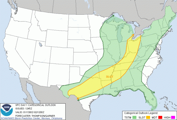
SEVERE WEATHER TODAY: The SPC has a large swath from Texas to the eastern Great Lakes outlined in a slight risk for severe weather. This does include some of our northwestern counties and runs roughly from Hamilton to Haleyville to Huntsville. The main storms should develop along a boundary that is slowly drifting south across the risk area. Main threat will be large hail and damaging winds, but a few tornadoes will be possible as well. Flood and flash flood watches and warnings are in effect in many areas as well. Any additional rainfall will only make conditions worse.
HEADING INTO SUNDAY: Frontal system dropping south will enhance our chance for rain and thunderstorms on Sunday. Not expecting any widespread severe weather, but a few storms could be strong and isolated severe storms could be possible. Most areas will see rain and some less humid air will settle in behind the front to start the workweek.
2013 HURRICANE SEASON BEGINS: Today is the first day of the Atlantic Hurricane season. From now until the end of November we will be watching the waters of the Atlantic. Several of the forecast for the season say it will be a very active season for the Atlantic Basin, but of course only time will tell. Andrea is the first name on the list this year.
BEACH FORECAST: It will be a beautiful weekend along the beaches of Alabama and Northwest Florida. Afternoon highs along the immediate coast will hang in the mid 80s while overnight lows settle into the mid 70s. There will be a strong onshore flow, so rip currents are a problem and red flags have been flying all week. At last check water temperatures at the Dauphin Island Sea Lab was 80 degrees.
THE WEEK AHEAD: We will start the work week off, with lower humidity and drier conditions. The weather will be very nice. Afternoon highs will be warm as 80s and a few 90s will be possible by midweek. Temps come down a bit later in the week, as humidity levels will be on the rise. We will have to introduce a chance of rain by Thursday with the increase in humidity. Increase in humidity will help showers and thundershowers develop more easily. No widespread rain, but just scattered showers to cool areas off from the afternoon heat.
WEATHER BRAINS: Don’t forget you can listen to our weekly 90 minute netcast anytime on the web, or on iTunes. This is the show all about weather featuring many familiar voices, including our meteorologists here at ABC 33/40.
CONNECT: You can find me on all of the major social networks…
Facebook
Twitter
Google Plus
Instagram
We will post updates later today as needed…
Category: Alabama's Weather


