Storms Less Than An Hour Out From West Alabama, but Weaker
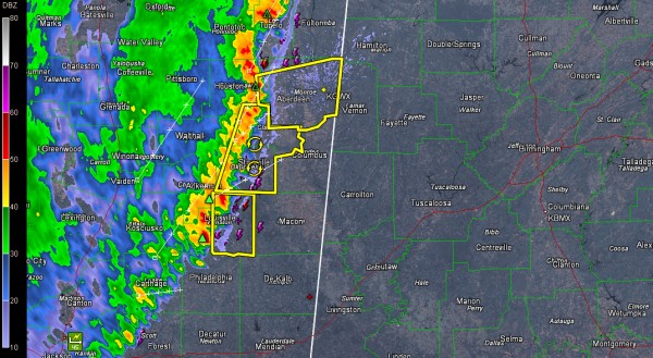
Our line of showers and storms has held together tonight, but it is slowly weakening.
It now extends from Corinth to Booneville to Tupelo to west of Starkville and Louisville.
It is now nearing just one county from western Alabama. It will reach Marion, Lamar and Pickens Counties around 1:30 a.m. It may be more like 2:30 for Sumter County.
A strong rush of outflow will precede the storms by 15 minutes or so. Winds could reach 50 mph or higher in this outflow.
The weakening trend will continue, but there may be a threat of damaging winds to 60 mph into parts of West Alabama, especially around Marion, Lamar and Pickens Counties. There is still lots of lightning, although it is decreasing. There could be some small hail with the stronger cores and heavy rain will continue to accompany these storms until they weaken completely.
Severe thunderstorm warnings continue for the Starkville/West Point and Louisville areas, stretching back to the eastern side of the Jackson Metro.
A severe thunderstorm warning was just issued for Monroe and Chicksaw Counties, including the Aberdeen and Amory areas.
Winds were estimated to 60 mph in Lafayette County MS at 11:29 p.m.
Several trees were repotred down in Hinds County MS, west of Jackson, between 11:20 and 11:45.
Category: Alabama's Weather, Severe Weather


