The Latest on the Severe Weather Threat
UPDATE: SPC’s latest mescoscale discussion on today’s severe weather threat is very similar to our thinking as well as the NWS Birmingham thoughts. Weather conditions will begin to deteriorate heading into the afternoon. Daytime heating and upper-level features begin to cause a greater chance for severe thunderstorms into the afternoon and evening hours.
We continue to monitor a developing severe weather situation across a large part of the southeastern U.S. including all of Alabama.
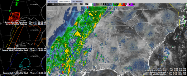
Here is a look at some of the factors we see in the equation here just after the midpoint of the morning:
UPPER FEATURES: Strengthening trough at 500 mb, with axis down through West Texas from upper level low over Nebraska. It will become negatively tilted today as a shortwave trough at 18,000 feet moves our way out of Texas. All of this will enhance the severe weather threat and will finally push our slow moving front and line of rain and storms eastward.
A jet max to our northwest will continue to push east and we will find ourselves in the right rear quadrant of that this afternoon, with good upper level divergence and corresponding surface convergence. All that pegging the geek meter says that storms will have a favorable environment to thrive in this afternoon over Alabama.
A low level jet at 5,000 feet was developing along the Louisiana Coast. This will translate northeastward into Alabama later today, also enhancing the wind shear.
SURFACE FEATURES: A surface low has formed near New Iberia, LA. This is a worrisome feature, as it will tend to enhance the low level shear to the southeast of it as it moves northeast. It should be in West Central Alabama by late afternoon.
It’s already becoming windier over eastern Mississippi. Winds are gusting to 22 at Columbus and 21 mph at Meridian.
The wavy front is over western Mississippi from about east of Jackson to east of Brookhaven. Temperatures drop about 20 degrees behind the front. It is now 68F at Jackson and 48F in Greeville.
TORNADO WATCH: Is in effect for southern Mississippi and Louisiana where the instability is high already. There are no severe thunderstorm or tornado warnings at this time.
RADAR: The main line of showers and storms now extends from west of Nashville to the northwestern corner of Alabama to near Jackson MS to Baton Rouge. It is moving east at only about 7 mph. A few light showers have broken out over West Central Alabama.
MOISTURE: Dewpoints have come up, now 64F at Tuscaloosa and 61F at Birmingham. It is 70F at McComb MS and 72F at New Orleans, indicating the rich moisture available. Precipitable water values are over 1.5 inches over Louisiana and southern Mississippi. This is near the 99th percentile for the time of year for Central Alabama. This air will advect into Alabama this afternoon, resulting in some heavy rains. Average rainfall amounts should be near two inches.
INSTABILITY: The mesoscale models are very bullish on instability values this afternoon, especially along and east of I-65, generally as far north at Birmingham. CAPE values may reach 1,500 joules up to Birmingham and surpass 2,000 joules further south and southeast. This is sufficient for intense updrafts to form.
SHEAR: There will be sufficient shear for those updrafts to rotate as bulk shear values approach 30-35 knows in the area of concern east of 65 and south of 20. Helicity values in the 0-1 km layer, which are critical for tornado formation, will be 150-200 m2/s2 over the area, setting the stage for the possibility of a few tornadoes.
BOTTOM LINE: A few organized storms will break out this afternoon over Central Alabama ahead of the front and main line of storms. They won’t be widespread, but some of those will become severe and there will be a few tornadoes. The best threat for tornadoes and damaging winds is along and east of I-65 and south of I-20. Main threat time is after 2 p.m.
GENERAL TIMING: Look for storms to increase over Northwest Alabama through early afternoon, reaching Tuscalooa and Cullman before 3 p.m., Birmingham just after 3 and Gadsden by 4 or so. Anniston will see these storms by late afternoon. The main squall line will push into western Alabama around 4, reaching the Birmingham area around 6-7 pm. and into east Alabama later. These time are just an initial estimate and could change if the system moves faster.
SCHOOLS: You are probably aware that most school systems are implementing early dismissals today. Check for the latest information from your school system if you have students.
THIS IS A DEVELOPING SITUATION: There is still some uncertainty in how the event will unfold, so stay tuned to the blog throughout the afternoon and evening until the storms are out of the area. Check your severe weather plan and have a way to get watches and warnings wherever you are.
Category: Alabama's Weather, Severe Weather


