Radar Check
A quick look at the radar this evening, we continue to see widespread severe weather to our west. A few showers have developed over Central Alabama this evening, but our real attention remains focused to the west, where a very dangerous situation is developing as the sun has set and the better dynamics are getting into place. The nearest thunderstorms to us are in the Mississippi Delta. Several tornado warnings are in effect in that area. These are the storms we are really going to have to watch as they are discrete supercells out ahead of the main line that is northwest of Little Rock. Additional severe thunderstorm and tornado warnings are in effect through Northern Arkansas and down into Central Louisiana, where other discrete supercells have developed. A very warm, moist air mass is in place across the Southeast. Not expecting temperatures to cool off much tonight. Southerly winds will increase overnight, pumping in more unstable air.
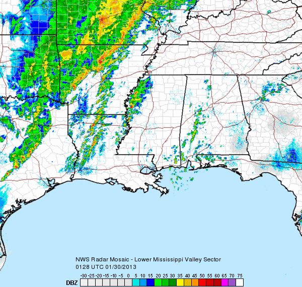
This activity will continue to move east into the overnight hours, and could be impacting portions of Northwest Alabama by 3 or 4 AM. Central Alabama will be under the gun during the morning hours, and many schools are operating on a delayed start.The main threat will be widespread damaging winds and isolated tornadoes. On top of the severe weather threat, flash flooding is becoming a threat as well. Numerous flood and flash flood watches and warning are in place to our west and we could see the advisories expanded to include Alabama.
Category: Alabama's Weather
About the Author (Author Profile)
Macon, Georgia Television Chief Meteorologist, Birmingham native, and long time Contributor on AlabamaWX. Stormchaser. I did not choose Weather, it chose Me. College Football Fanatic. @Ryan_StinnetSubscribe
If you enjoyed this article, subscribe to receive more just like it.


