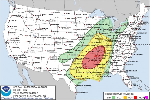
SPC Expands the Moderate Risk Area
The new severe weather outlook from the SPC is out and the most interesting thing is that the moderate risk area was expanded into the Ohio Valley. Areas now from southern Indiana and Illinois all the way back into northeastern Texas are included in the moderate risk area, including the northwestern half of Mississippi. The moderate risk area just clips the northwestern corner of Alabama. A moderate risk indicates an enhanced chance of severe weather, including the possibility of widespread damaging winds and tornadoes from a line of intense storms and the possibility of tornadoes form supercell storms out ahead of the main line.
The standard slight risk area looks generally the same. It covers large area from Chicago and Houston east to Pell City. Generally the northwestern half of Alabama is included.
No real change in the thinking for us. An intense line of thunderstorms will sweep across Alabama tomorrow morning, reaching northwestern sections around sunrise, Birmingham around mid-morning and out of East Alabama by 1 p.m. This line will have the potential to produce widespread damaging winds. There will also be the threat of embedded tornadoes.
But ahead of this line, individual storms will form over Mississippi late tonight and will push into western Alabama after midnight, between 12 a.m. and 2 a.m. These storms will push deeper into Alabama, across areas from the Shoals over to Huntsville and back down through Hamilton, Jasper and Cullman southward to Tuscaloosa and westward back to the Mississippi border.
These storms will have the potential to be of the supercell variety, which makes them prone to produce tornadoes.
These advance storms should weaken, or be overtaken, by the main line of storms which will push through during the morning hours.
The good news for now is that the persistent clouds are helping to keep the temperatures in check across Central Alabama. Readings are in the 60s. But dewpoints are already in the lower 60s and rising across southwestern Alabama. They are in the upper 60s over southern Louisiana. This rich moisture will continue to be lifted northeastward by the strong southerly surface winds that will be developing across the area in response to the strengthening low over the Red River Valley of Texas and Oklahoma.
And there is some clearing beginning to develop back over southwestern Alabama, Central/southern Mississippi and northeastern Louisiana. You will see some peek a boo sunshine around here this afternoon, allowing temperatures to warm into the lower to middle 70s. This has led to concern that there will be a little more instability than earlier thought across Central Alabama late tonight and early in the morning. Without question, there will be strong wind shear. The combination could allow for any individual storms that can form ahead of the main line to produce tornadoes.
Then of course, we will deal with the strong possibility of damaging winds over a wide area with the main line of storms, as well as the possibility of embedded tornadoes.
Needless to say, all Alabama residents should review their severe weather safety plans (good checklist here), have a reliable source of watches and warnings within earshot at all times starting tonight and be ready to act immediately if a warning is issued for their location.
And as a side note, some people do not pay enough attention to severe thunderstorm warnings. All it takes is one tree crashing on your home or car to cause serious injury or even death. Please heed any kind of warning you get for your location, but pay close attention to the severe thunderstorm warnings tonight as well. It could save your life or the life of someone you love.
We will have frequent updates on this developing severe weather situation right here on the blog throughout the day, overnight and through the day tomorrow. Expect updates at least every couple of hours until watches are issued for Alabama late tonight. Then you can expect more frequent updates and of course, warnings instantly with radar images and color commentary.
Category: Alabama's Weather, Severe Weather


