Some Freezing Rain Early Tomorrow For North/East Alabama
An all new edition of the ABC 33/40 Weather Xtreme video is available in the player on the right sidebar of the blog. You can subscribe to the Weather Xtreme video on iTunes by clicking here.
THIS AFTERNOON: A cold front bisects Alabama. North of the front, at 2:00 Decatur reports a chilly 43 degrees, while south of the boundary Montgomery reports 66. Nice 23 degree spread on either side of the front. Cold air will win the battle tonight as the front continues to move slowly to the south.
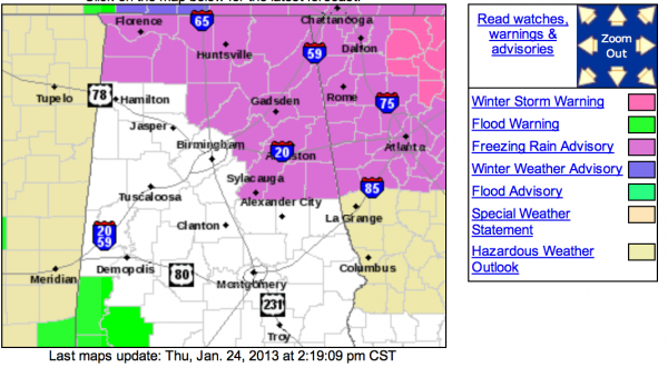
ICING ISSUES: The NWS offices in Birmingham and Huntsville continue a freezing rain advisory for these Alabama counties late tonight and tomorrow…
Not much overall change in our thinking; temperatures will be at or just below freezing over parts of North and East Alabama after midnight, and as precipitation moves in, we have potential for a little freezing rain.
I think the best chance of really significant bridge icing is along and east of a line from Athens to Gadsden to Anniston to Roanoke, everybody in the advisory area will need to take it easy driving, and watch for icing on bridges and overpasses. Temperatures will rise above freezing by mid-morning, with the possible exception of Jackson, DeKalb, and Cherokee Counties, where some patchy bridge ice would linger into the midday hours.
This is not the kind of event that will bring heavy ice accumulation, and no power outages are expected. And, no snow since the cold air is too shallow.
Rain will end from west to east tomorrow afternoon; totals should be under 1/2 inch.
THE ALABAMA WEEKEND: Cool and dry weather is the story; highs in the 50s Saturday and Sunday with a partly sunny sky both days. Early morning lows will be near the freezing mark.
SEVERE WEATHER NEXT WEEK: We warm up in a big way early next week; maybe even reaching 70 degrees by Tuesday afternoon ahead of a storm system lifting out of the Southwest U.S. SPC has much of Arkansas and some of the adjacent states outlooked for severe weather on Tuesday, and we could very well be dealing with strong to severe storms late Tuesday night into Wednesday. Still way too early to be really specific on this threat. Colder and drier air follows the rain Thursday.
WEATHER BRAINS: Don’t forget you can listen to our weekly 90 minute netcast anytime on the web, or on iTunes. This is the show all about weather featuring many familiar voices, including our meteorologists here at ABC 33/40.
CONNECT: You can find me on all of the major social networks…
I am headed down to the BJCC where I will be the Ringmaster for opening night of the circus…. look for the next Weather Xtreme video here by 7:00 a.m. tomorrow…
Category: Alabama's Weather


