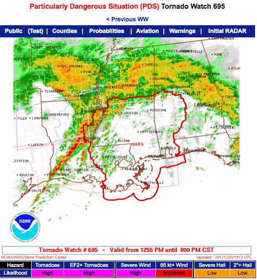
PDS Tornado Watch for West Central, Southwest Alabama
The NWS has issued a Particularly Dangerous Situation Tornado Watch for southwestern Alabama, southern Mississippi and southeastern Louisiana.
A line of intense thunderstorms is pushing across Central Louisiana and into southwestern Mississippi. Ahead of this and south of the warm front, the airmass is becoming moderately unstable and wind fields are extremely strong. This means that any storms that form ahead of the main line have the potential to produce strong, long track tornadoes.
Storms along the line will produce widespread damaging winds and more tornadoes later tonight as they move through.
WWUS64 KBMX 251858
WCNBMX
WATCH COUNTY NOTIFICATION FOR WATCH 695
NATIONAL WEATHER SERVICE BIRMINGHAM AL
1258 PM CST TUE DEC 25 2012
ALC047-063-065-091-105-119-260200-
/O.NEW.KBMX.TO.A.0695.121225T1858Z-121226T0200Z/
THE NATIONAL WEATHER SERVICE HAS ISSUED TORNADO WATCH 695 IN
EFFECT UNTIL 8 PM CST THIS EVENING FOR THE FOLLOWING AREAS
IN ALABAMA THIS WATCH INCLUDES 6 COUNTIES
IN CENTRAL ALABAMA
DALLAS PERRY
IN WEST CENTRAL ALABAMA
GREENE HALE MARENGO
SUMTER
THIS INCLUDES THE CITIES OF…DEMOPOLIS…EUTAW…GREENSBORO…
LINDEN…LIVINGSTON…MARION…MOUNDVILLE…SELMA…
UNIONTOWN AND YORK.
Category: Alabama's Weather, Severe Weather


