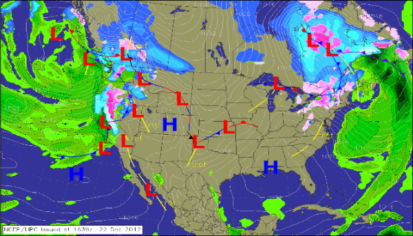
Saturday Afternoon Weather Map
A look at the weather map this afternoon, we can see the storm system that impacted us earlier in the week with severe weather in the Southeast and blizzard conditions from the Plains into the Great Lakes, is pushing off the Northeast coast of the U.S. Still causing some lake effect snows in Pennsylvania and Upstate New York. That system swung a strong cold front across the eastern half of the U.S. Behind the front an area of high pressure, currently centered on the Northern Gulf Coast has become the dominant feature affecting our weather. The high brought colder air and a brisk northwest wind. As it is nearly centered over us, the winds have gone nearly calm over us, but with all the subsidence associated with it, no rain and hardly a cloud in the sky across the Southeast. Despite the cool air, it is a very beautiful day across the southern tier of states.
For the rest of today, the high will slide off to the east and will allow for a southerly flow to return across our part of the South. More moisture and warmer temperatures will be noticed as soon as tonight, with many areas in central Alabama only settling into the mid 30s. Low pressure in West Texas will also help pump in additional moisture from the Gulf. Unsettled weather will settle in across the Southeast the next few days.
 Across the rest of the country, another strong Pacific system is moving onshore causing flooding rains and mountain snows from Central California all the way north along the Interstate 5 corridor to Southern Canada. Most of that moisture will be squeezed out of the atmosphere as it lifts over the mountains. For the central and U.S., cold air has settled in. The air is cold enough where the recent snow should only melt slowly.
Category: Alabama's Weather


