Afternoon Update
It has been a mixed bag of clouds and some sun across Central Alabama on this December Sunday. Patchy dense fog developed in areas that saw clear skies overnight, but visibilities were generally not too limited. Overnight lows looked more like the highs we would typically see in December, with morning temperatures in the middle and upper 50s.
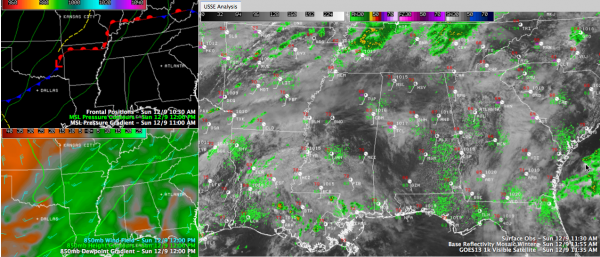
A LITTLE MORE SUN TODAY: Parts of the area have seen more sunshine today as slightly drier low level air was working into Central Alabama this morning. That and mixing from increasing southerly winds should yield increasing sunshine. A little more solar insolation today should allow the mercury to reach the lower 70s, like we advertised yesterday in more locations. We note that Tuscaloosa was just at 60F at 11 a.m. The western Tennessee Valley was already in the 70s!
RADARS WILL BE HEATING UP: Numerous showers and thunderstorms were lined along a warm late this morning, from north of Nashville to north of Memphis to near Little Rock and Hot Springs, Arkansas. Surface low pressure was moving into western Arkansas early this afternoon. This low will intensify as it pushes northeast ahead of a trough that is digging southeastward. As the low tracks toward the Missouri Bootheel late this afternoon, its accompanying cold front will get its act together and will push toward the Memphis area. Showers and storms will spread into western Tennessee and northern Mississippi late today and this evening. The SPC does forecast severe weather for places like Jackson, TN, Memphis, Little Rock, Greenville, MS, Shreveport and Lufkin, TX.
WHAT ABOUT US? The SPC has the northern half of Alabama included in their standard slight risk severe weather outlook for Monday. Instability will be very limited, which makes the situation marginal. But there will be decent wind shear, and an approaching upper level disturbance could help trigger a few severe thunderstorms. The main threat will be damaging winds and some hail. We will have to watch for the development of one of those mesoscale convective vortexes that can produce organized damaging winds.
TIMING: Some showers and thunder will spread into Central Alabama this evening, generally after 8 p.m. as a surge of moisture enters the area. This activity won’t be severe. The main line of showers and storms will enter northwestern Alabama after midnight and will push slowly southeastward overnight. By sunrise, it still may be northwest of Birmingham, probably not reaching the I-59 corridor until 9-10 a.m. There may be a narrow window for that severe weather during the morning as the upper disturbance swings by. The activity should weaken during the afternoon as it pushes southeast and the upper level energy lifts out to the northeast.
RAINFALL AMOUNTS: The precipitation will end from the northwest during the late morning and early afternoon. Rainfall amounts, especially north of I-20, could approach one inch, with lessening amounts to the south.
SHARPLY COLDER: The cold front powering the rain and storms will be noticeable. Winds will shift to the northwest behind it and will become quite brisk, ushering in much colder air. Morning readings will fall behind the front over Northwest Alabama, and folks in the Gadsden, Birmingham and Tuscaloosa areas will also notice a falling thermometer by early afternoon. The mercury will be in the 40s by early evening, on its way to the lower and middle 30s by Tuesday morning.
Category: Alabama's Weather, Severe Weather


