Discussion of Storm Surge
When people think of hurricanes, it is probably the wind that comes to mind first. But while the wind is a big part of the impact of a hurricane, it is actually the storm surge that has the greatest potential to produce great devastation and loss of life IF people along the coast do not heed evacuation recommendations.
So what is the storm surge? Storm surge is created by three primary factors, the wind, the waves, and low pressure. These three elements contribute to the storm surge to create massive destruction.
The wind circulating around the hurricane acts to pile up water especially on the right side of the storm, right side determined by the direction in which the storm is moving. The wind typically accounts for 85 percent or more of the surge.
On top of the water, waves push water inland faster than it can drain back to sea. The wave set-up as it is called accounts for about 5 to 10 percent of the surge.
The low pressure of a hurricane contributes to raising the height of the water close to the eye. Like the wave set-up, this accounts for about 5 to 10 percent of the surge.
There are additional factors which contribute to increasing or decreasing storm surge. First, storm surge depends largely upon the size and intensity of a hurricane. Then there is the angle at which the hurricane approaches the shore. Further factors include the slope of the seabed along the coastline together with the depth of the water close to shore, whether the surge comes with low tide or high tide, and the speed at which the hurricane is moving.
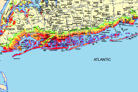
A computer model has been developed which tries to take all of these factors into account to arrive at some idea of what the surge is likely to be with a particular storms. The model is called SLOSH and stands for Sea, Lake and Overland Surges from Hurricanes. The map below has been created by using the current estimate strength of Sandy along with its speed and direction of travel. This also assumes the approach of Sandy coincides with high tide.
The areas in red are projections for a Category 1 hurricane as Sandy is expected to be. Category 1 hurricanes inundate just about all of the immediate south shore of Long Island, including the north side of Great South Bay locations and both sides of the north and south forks.
Keep in mind that there will be wind affecting a large area and rain affecting a wide area with widespread amounts of 5 to 10 inches over a couple of days. So this storm is NOT being hyped. Sandy poses a very serious threat to a very large area, and it is my hope that people from the Carolinas to Ohio to Maine and all of the states in between will take Sandy seriously.
-Brian-
Category: Tropical


