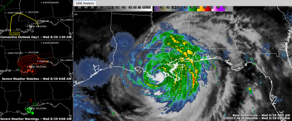
Rough Night in Louisiana
It has been a very rough night in southeastern Louisiana.
The storm is very powerful still: 970 mb/80 mph.
It is centered just southeast of Houma. It is finally moving west northwest at 6 mph.
Heavy rain has pounded the area all night long. 3.26 at New Orleans International. Flash flood watches and warnings continue.
High winds continue. Winds are gusting to over 60 mph in New Orleans now. Winds at New Orleans have been gusting over 55 mph since before 7 p.m. last night.
Flooding is being reported is areas south and east of New Orleans where flood waters are overtopping back levees. Residents report water to tops of doorways in Braithwaite, just south of New Orleans. The overtopped levees are not governmentally maintained levees. The Mayor of New Orleans stresses that there are no levees problems with the levees in New Orleans. Pump stations are all operating (some on generators).
Tornadoes are still a threat. There have been several tornado warnings in southern Mississippi.
Heavy rain continues from Mobile County in Southwest Alabama over the southern third of Mississippi over all of southeastern Louisiana.
75% of New Orleans as no power. 420,000 in Louisiana, 4,000 in Mississippi.
Category: Tropical


