Lots of Information
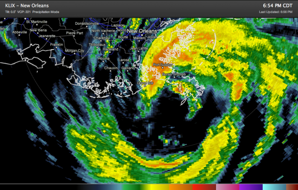
Hurricane Isaac appears to be about to make landfall near the Southwest Pass of the Mississippi River. This is 85 miles southeast of New Oleans.
The definition of landfall is when the center of the tropical cyclone crosses the coast. A small inner eyewall appeared to form this afternoon in the larger center, and if you use this center, it is making landfall.
The marshy area where the hurricane is making this initial landfall is not going to weaken it.
Pressure is around 970 mb. Plane just found 971 mb.
Top winds 80 mph.
Moving NW at 8 mph.
NOTES:
Tornado watch is about to be extended in time for southeastern Louisiana, southern Mississippi, southwestern Alabama and parts of the Florida Panhandle.
NWS Birmingham has been watching the storms over South Central Alabama. Some of them have shown a tendency to rotate. Can’t rule out an isolated tornado over South Central Alabama even outside the watch.
At 6:30, winds gusted to 61 mph at New Orleans’ Lakefront Airport. At Louis Armstrong International, winds are northerly at 32 gusting to 49.
An intense band of storms is rotating toward southern Jefferson Parish. Some 80+ mph gusts may be in this band. The northern end of it will cross the City of New Orleans. It will also rotate through St. Charles, Lafourche and Terrebonne Parishes.
Buras gusted to 83 mph at 5:54.
At Petit Bois Island (west of Dauphin Island), winds are ENE 40 gusting to 53 mph.
At a platform 74 miles south of Dauphin Island, winds were SE at 63 mph gusting to 77 mph.
Tide at Shell Beach LA now nearly 9 feet above normal. Numerous gusts over 55 knots at Shell Beach in St. bernard Parish, southeast of New Orleans.
The Mississippi River has risen 4 feet at New Orleans since this morning.
Watch WWL TV live coverage here.
Category: Alabama's Weather, Tropical


