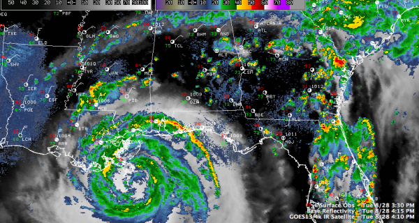
4 p.m. Update: Isaac Stronger
Isaac is a little stronger. Top winds are now 80 mph.
It certainly is better organized than it has ever been. It is over warm water and the shear and dry air have abated a bit. The extra time over water and better inner core may allow winds to increase 5-10 more mph.
4 PM FAST FACTS
———————————————-
LOCATION…28.7N 89.2W
ABOUT 30 MI…45 KM SSW OF THE MOUTH OF THE MISSISSIPPI RIVER
ABOUT 105 MI…170 KM SSE OF NEW ORLEANS LOUISIANA
MAXIMUM SUSTAINED WINDS…80 MPH…130 KM/H
PRESENT MOVEMENT…NW OR 310 DEGREES AT 8 MPH…13 KM/H
MINIMUM CENTRAL PRESSURE…975 MB…28.79 INCHES
The hurricane has been wobbling over the past several hours. In fact, the motion over the past few hours has been westward. The average motion is northwest at 8 mph. It has certainly slowed, and this is expected to continue through tomorrow.
Landfall should occur near Barataria Bay west of Buras around midnight tonight.
A tornado watch continues for areas from Southeast Louisiana to Santa Rosa County in NW Florida.
CENTRAL ALABAMA UPDATE
The outer feeder band that passed through the I-20 corridor earlier is north of Birmingham and weakening. It strecthes from Hamilton to Cullman to Gadsden roughly. A few scattered showers and storms are south of the feeder band. Some are in Marengo County near Linden. Some are along I-85 from Montgomery to Auburn.
SOME REPORTS
Main Pass 255 p.m. sustained 67 mph with a gust to 93 mph.
Mississippi Canyon platform 315 p.m. 64 mph with gusts to 87 mph.
Boothville 40 mph gusting to 62 mph at 3:30 p.m.
TIDES
Shell Beach LA running 6.5 feet above normal tide
Waveland MS running 4 feet above normal tide
Pascagoula MS running 3 feet above normal tide
Dauphin Island running 3.74 feet above normal tide
Pensacola running 3.5above normal tide
Category: Alabama's Weather, Tropical


