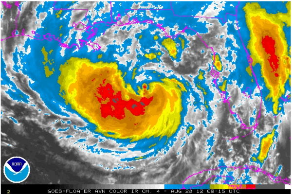
A Center Exposed
Isaac is still right on the verge of being classified as a hurricane tonight. But the Hurricane Center has made a good cal so far not upgrading it, yet.
Here are the FAST FACTS on the storm at 7 PM:
———————————————-
LOCATION…26.7N 86.5W
ABOUT 230 MI…370 KM SE OF THE MOUTH OF THE MISSISSIPPI RIVER
ABOUT 295 MI…470 KM SSE OF MOBILE ALABAMA
MAXIMUM SUSTAINED WINDS…70 MPH…110 KM/H
PRESENT MOVEMENT…NW OR 305 DEGREES AT 10 MPH…17 KM/H
MINIMUM CENTRAL PRESSURE…981 MB…28.97 INCHES
After a strong burst of convection during the day, dry air wrapping into the circulation really knocked the storms near the center down and that center is exposed tonight. But new deep convection was wrapping around the southern side of the center and it will be interesting to see if the convection can hold together overnight.
Top winds are 70 mph. The reconnaissance planes have found lots of 70 knot flight level winds in both semicircles of the storm. But the observations from the planes have not indicated SFMR data that supported upgrading it to hurricane strength. Still, don’t be surprised to see that happen shortly.
Extrapolating the fixes still indicates a steady northwest motion. Several of the models and the official forecast all indicate that the storm will slow over its forward motion over the next 24 hours. Isaac is expected to make landfall near or just west of the Mississippi river late tomorrow afternoon. It will move slowly northwest, passing New Orleans late tomorrow night. It will then take nearly 24 hours for it to make the short jog to Baton Rouge.
This could lead to some biblical rainfall amounts over southeastern Louisiana. At least two of our models show the storm stalling just northeast of New Orleans, keeping South Mississippi and Southwest Alabama in the area of extreme rainfall. Let’s hope we don’t have another Hurricane Danny, which dumped over 36 inches of rain in 24 hours on Dauphin Island in 1997 as it stalled over Mobile Bay.
The big storm, its slow movement and extended duration of onshore winds in the eastern semicircle will push large amounts of water onto the coast in the funnel near the Louisiana/Mississippi border, the Mississippi coast and into Mobile Bay. Tides may reach 6-12 feet in parts of this area. The probability of a surge six feet or greater is currently 10% in Mobile Bay, 30% at Biloxi, 40-50% at Gulfport, and up to 60% on the eastern facing shores of the parishes east and southeast of New Orleans.
Tornadoes will be possible tomorrow over southern Alabama, southern Mississippi, southeastern Louisiana, the Florida Panhandle and southwestern Georgia. This area will expand northward to a iine along US-78/US-280 in Alabama on Wednesday.
A wide area over Mississippi, southeastern Louisiana and southwestern Alabama will see between 10-20 inches of rain from Isaac. Over Central Alabama, we are forecast to see 3-5 inches of rain as heavier outer bands set up across the area at times.
Join us on the WeatherBrains podcast for a special Isaac show at 8:30.
Category: Tropical


