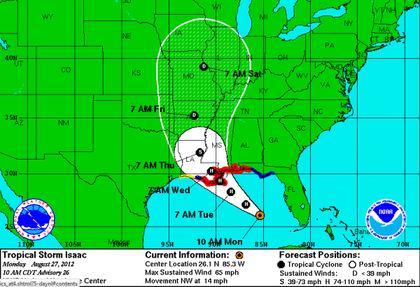
10 a.m. Notes
The latest information from the National Hurricane Center shows that Isaac is getting better organized, but has not strengthened as winds remain at 65mph. The storm continue to move NW at 14 mph. The latest track from the National Hurricane Center shows that the models are beginning to line up and it looks like there will be a direct hit on the the city of New Orleans.
Rapid intensification is not expected, but Isaac is expected to become a Hurricane by the end of today. By landfall tomorrow, near New Orleans, Isaac should be a strong category 1 hurricane maybe a category 2 hurricane.
Along with the winds, expect severe weather especially on the east-side of the storm. Feeder bands will be spinning around the center of circulation and within these bands, tornadoes are very possible. These bands could be affecting Atlanta, Birmingham, Montgomery and Jackson, Mississippi as the storm works its way inland.
Flooding will become a major threat as rainfall totals could be in access of 12 inches for parts of southern Alabama, Mississippi and Louisiana. Flood watches and warning are being issued all across parts of the Southeast as substantial amounts of rain are expected to fall the next 72 hours.
Storm surge will be the greatest on the east side of the storm. Along the coast of Mississippi, storm surge is expected between 6-12 feet. This will pose a significant threat to many communities from northwest Florida, west through much of southeast Louisiana. Many of the areas that were hard hit by Katrina. This is not Katrina though, and the widespread devastation is not expected. Evacuations have been issued for many coastal communities along the Northern Gulf Coast, especially the areas that have little or no protection from the rising surge waters.
After landfall, Isaac is expected to continue to work to the NW towards Arkansas and Missouri. This would be very beneficial in alleviating the exceptional drought conditions across much of that region.
Category: Alabama's Weather


