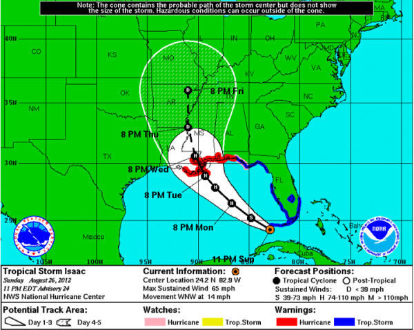
Detailed Analysis of New Forecast Track
The new forecast package is in from the National Hurricane Center and it is shifted a little further westward again. There has been significant difference in the output of the various dynamical models with Isaac. Hopefully they will come into better agreement today. One camp predicts that Isaac will exploit a weakness in the ridge over the northern Gulf and reach the Alabama or Northwest Florida coast, leading to big impacts across Central Alabama. Another camp, including the GFS, believes that the storm will be steered more westward, south of New Orleans and along the Louisiana coast toward Texas. If that happens, the impact on Central Alabama will certainly be lessened.
Less look at impacts based on the current NHC forecast:
The late night package shifted a little west over the New Orleans area.
Hurricane warnings are in effect from Morgan City to Destin, including all of the Mississippi and Alabama coastlines, and the New Orleans Metro area.
Isaac should become a hurricane Monday morning. A hurricane watch is in effect to east of Panama City. Evacuations will start in Mobile and Baldwin Counties Monday morning, as well as several parishes in southeastern Louisiana.
If this track materializes, here are some of the impacts that can be expected.
Tropical storm force winds will reach coastal Alabama, Mississippi, Northwest Florida and Southeast Louisiana between midnight and dawn tonight. By then, the storm should be slowing its forward motion. Also, the storm will be over some warmer water and should be moving away form the upper low that has been impeding it. We will then be watching for rapid intensification.
Heavy rain and squalls will be moving inland along coastal areas as well. Strong tropical storm force winds will reach southeastern Louisiana tomorrow afternoon, and the area from New Orleans to Biloxi during the evening. Strong tropical storm force winds may stay west of Mobile and Baldwin Counties in this scenario.
Hurricane conditions should arrive at the mouth of the Mississippi River late tomorrow night and reach new Orleans during the morning hours Wednesday. They could last up to 10 hours if the motion slows as expected.
Landfall should be near Buras, Louisiana late Tuesday night, with the eye passing over New Orleans during the morning Wednesday.
Winds should become onshore by early Tuesday afternoon around Apalachicola and that trend will spread westward during the day Tuesday, reaching Destin by evening. When the winds shift, tides will rise rapidly, with storm surge values running around 6 feet over the eastern Florida Panhandle and as high as 12 feet in the funnel between the Mississippi Delta and the Mississippi Gulf Coast, back over to Mobile Bay early Wednesday as winds come onshore there as well.
Tornadoes will also be likely in the northeastern quadrant of the storm over southern Mississippi, Alabama and Northwest Florida.
Rainfall amounts will range up to 10-20 inches across southeastern Louisiana, southern Mississippi, southern Alabama and extreme northwestern Florida.
CENTRAL ALABAMA IMPACTS: If this track materializes, Central Alabama will see showers and storms in feeder bands that will develop Tuesday, continuing at times through Wednesday. Alabama will be in a favorable position to see a few tornadoes. Winds will be gusty at times, but they won’t be damaging. Rainfall amounts should range between 1-2 inches, higher over the west. Things should begin to improve on Thursday as Issac moves up into the drought ravaged areas of Arkansas and Missouri.
STAY TUNED: There is still great uncertainty in this forecast, so please stay apprised of the latest forecast developments until Isaac makes landfall. Remember, that the center of the storm could end up anywhere in the cone of uncertainty, that white shaded area on the graphic. If the track shifts, the impacts will shift as well.
Category: Alabama's Weather, Tropical


