Finding the Center
You put your GFS in,
You take your GFS out,
You put your EURO in
And you shake it all about.
You do the hokey pokey,
And you turn yourself around,
That’s what it’s all about.
I had to laugh out loud when I saw James’ blog post a little while ago as the models started shifting back east after a couple of days of shifting west with the track of Isaac. He likened it to the hokey pokey. You have to scroll down and read it.
That’s a lot of what it will be like. The models just show a range of possible solutions with the track and intensity of Isaac. Of course, those factors will have big impact along the U.S. Gulf Coast in the next 120 hours.
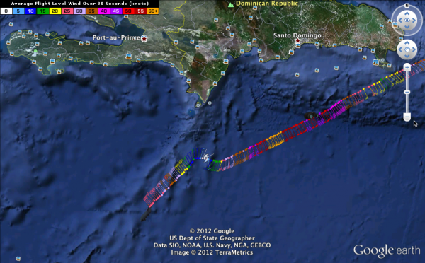
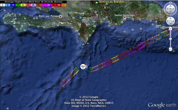
I wanted to show an interesting Google Earth depiction of recent recon data where the Hurricane Hunters found the center. They obviously deviated a little to the right as they approached the center, probably following a radar presentation. The winds inbound to the center reached 70 knots at flight level (about 4700 feet). You discount that by 10% for translation to surface winds. So take 63 knots, which is 73 mph, and Isaac is right below hurricane intensity.
Southeasterly winds decreased as the Hurricane Hunters approached the center, they shifted to southwesterly, they then dropped to less than 5 knots and shifted to northeast as the plane moved to the other semicircle.
They measured a central pressure of 995 millibars. That’s down 5 mb from this morning. So Isaac is getting more organized.
It seems to be that the outflow is improving. Storms seems to be filling in around the center, and Isaac will likely continue to get a little better organized, especially if the center can avoid the mountains of southwestern Haiti. It will encounter Cuba by noon tomorrow. This will likely weaken the system back a bit. It will probably emerge into the Florida Straits north of Cuba 24 hours later as a 50 mph tropical storm. About 24 hours later, it will be a hurricane again. By then, we will probably see hurricane watches along portions of the northern Gulf Coast and we will have a better idea of where the dance will end.
Category: Tropical


