Severe Weather Tomorrow Night?
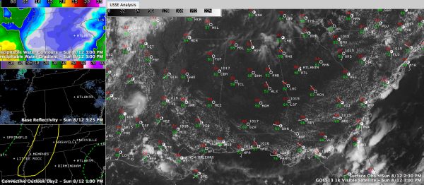
High pressure is firmly in control of our weather on this August Sunday afternoon, with high pressure centered over Central Tennessee, ridging down into Alabama. Moisture is nearly non-existent, at least by summer stands in North and Central Alabama.
Preciptable water values are running between 0.50” and 0.75” across the area. The 0.63” reading at Birmingham this morning is well over two standard deviations lower than normal and in record territory for this time of year!
Skies are mostly clear with just a few high clouds up in the Huntsville area at mid-afternoon. This cloudiness was drifting southeast in the upper flow and will give the sky a little character over northeastern sections of the state through the rest of the afternoon. The mercury is heading toward the upper 80s. Tonight, temperatures will fall back into the lower 60s in many areas, with a few 50s sprinkled in. So, get ready for another confortable night.
STORMS RETURN MONDAY: We will actually be monitoring for a severe weather situation on Monday afternoon and night across North and Central Alabama, so heads up. On the weather maps tomorrow morning, we expect to find a decent surface low north of St. Louis with a cold front trailing back to near Wichita Falls. This front will be near Little Rock by sunset Monday evening. Showers and storms will be ongoing ahead of the front.
The SPC has already outlooked areas from Louisville to Memphis to the Mississippi Delta in a slight risk for tomorrow afternoon and evening. The storms will work into Alabama overnight. Moisture levels will rebound over Central Alabama and there will be a bit of a southwesterly breeze tomorrow. Highs will warm back into the lower 90s again. Some of the wind shear parameters will be there for severe weather Monday night, so we will be monitoring. There is not much certainty in this forecast. The storms could hold off until Tuesday morning, which might minimize the severe weather chances. Stay tuned.
HUMP DAY: The front probably will stall out over North Central Alabama on Tuesday afternoon and will head back north as a warm front on Wednesday. High pressure should give us decent weather for Wednesday, with very low rain chances and seasonally hot temperatures.
THURSDAY AND BEYOND: We find ourselves back in a tropical soup on Thursday with lots of humidity and plenty of heat. Scattered storms will be the norm de rigeur on Thursday with that fuel lying around. Another front will start to approach the area Thursday night. That front will be hanging around through Friday and will wash out over the weekend. We will be watching for the possibility of severe weather Thursday into Friday.
Category: Alabama's Weather, Severe Weather


