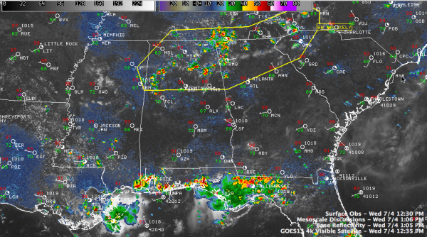
Mesoscale Discussion Issued
The thunderstorms developing over North Alabama are the subject of a mesoscale discussion (MCD) just issued by the SPC>
They issue mesoscale discussions to notify local offices and the public when strong to severe storms are expected to develop in an area.
From their website:
The MCD basically describes what is currently happening, what is expected in the next few hours, the meteorological reasoning for the forecast, and when/where SPC plans to issue the watch (if dealing with severe thunderstorm potential). Severe thunderstorm MCDs provide extra lead time on the severe weather development and allow you to begin gearing up operations before a watch is issued.
Starting this year, the forecasters started adding a probability that a watch would be issued. Note the low number in this one.
MESOSCALE DISCUSSION 1388
NWS STORM PREDICTION CENTER NORMAN OK
0102 PM CDT WED JUL 04 2012
AREAS AFFECTED…NRN AL / SRN MIDDLE TN / NRN GA / WRN NC / UPSTATE
SC
CONCERNING…SEVERE POTENTIAL…WATCH UNLIKELY
VALID 041802Z – 041900Z
PROBABILITY OF WATCH ISSUANCE…5 PERCENT
SUMMARY…SCTD TSTMS WILL CONTINUE TO DEVELOP THIS AFTERNOON. PULSE
STRONG TO LOW-END SEVERE STORMS CAPABLE OF ISOLD POCKETS OF
LOCALIZED WIND DAMAGE ARE EXPECTED WITH THIS ACTIVITY.
DISCUSSION…SATELLITE/RADAR/SURFACE COMPOSITE SHOWS A GROWING CU
FIELD WITH SCTD STORMS DEVELOPING AS TEMPS WARM THRU THE 80S IN THE
SRN APPALACHIANS AND WELL INTO THE 90S TO NEAR 100 DEG F FARTHER W
OVER NRN AL. THIS HAS LED TO VERY STEEP LOW LEVEL LAPSE RATES
WITHIN A VERY WEAK WIND PROFILE –INDICATIVE OF A PULSE TSTM
ENVIRONMENT. MODIFYING THE 12Z BMX/FFC RAOBS FOR MID 90S TEMPS WITH
A WELL-MIXED BOUNDARY LAYER DEWPOINT IN THE LOWER 60S YIELDS
2000-2500 J/KG MLCAPE. WITH PW VALUES IN THE 1.5-1.8 INCH
RANGE…COLLAPSING TSTM CORES VIA WATER LOADING WILL PROBABLY YIELD
ISOLD POCKETS OF WIND GUSTS 45-60 MPH CAPABLE OF WIND DAMAGE.
..SMITH/THOMPSON.. 07/04/2012
ATTN…WFO…GSP…MRX…FFC…OHX…BMX…HUN…MEG…JAN…
LAT…LON 35268161 34328243 33448519 33448830 34168859 35338728
35388431 36018207 35768158 35268161
Expect a few severe thunderstorms over the northern half of the state this afternoon. Some wind damage reports will be likely.
Stay alert this afternoon and keep an eye to the sky.
Category: Alabama's Weather, Severe Weather


