Early Evening Big Picture
It’s been a beautiful day across Central Alabama. Once the sun burned away the low clouds, the mercury warmed quickly. It was 81F at Anniston, 83F at the Birmingham Airport, 85F at Calera and 86F at Tuscaloosa. Throw in a nice southerly breeze and it was quite balmy. Moisture levels are still relatively low, with dewpoints in the 50s once the atmosphere turned over with the sunshine.
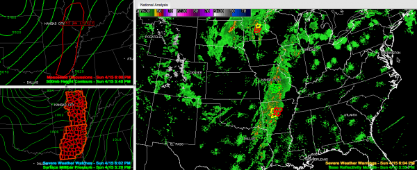
We continue to monitor severe weather to the west of Alabama. We have a long, broken squall line from northern Illinois through eastern Missouri, into western Arkansas and then eastern Texas.
Tornado watches are in effect now ahead of the line from eastern Missouri and Illinois into Arkansas and close to the powerful surface low over the Upper Midwest. A new watch is being considered for more of Illinois.
Severe thunderstorm and tornado warnings are in effect in Minnesota and Arkansas. There are flash flood warnings in Missouri.
So far, today nothing like yesterday. Ten reports of tornadoes so far, mostly over the Upper Midwest near the low.
Our line of storms will weaken tonight after crossing into Mississippi. We will see re-development during teh early morning over West Central Alabama. This will fill in up the line along I-59 generally through the morning and push eastward during the afternoon.
We could see a few strong or even severe storms tomorrow, but significant severe weather is not expected and the main threats would be damaging winds and hail anyway. We will be watching.
Category: Alabama's Weather, Headlines, Severe Weather


