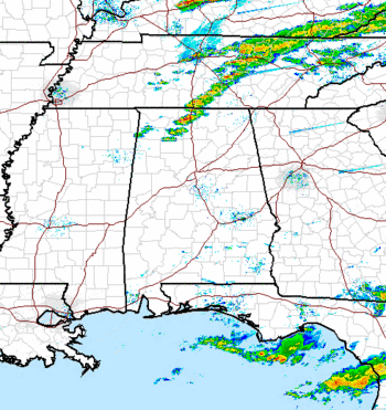
Severe weather update – 538 pm
The weather situation continues to develop over AL this evening. A persistent area of storms in Tennessee has produced an outflow boundary that is now moving into northern Alabama, and thunderstorms have fired on this boundary.
I was starting to wonder how we were going to get the high dewpoints and shear the models were predicting (due to winds out of the SW instead of SSW or S), but then, between 4 and 5 pm, the surface winds at many spots in central AL backed around out of the SSW. At TCL, for example, wind direction went from 220 degrees to 190 degrees in one hour. If this continues, it will bring Gulf moisture in here faster and produce larger wind shear (helicity has already increased to 300 m2/s2 over most of AL).
We at UAH have been examining the changes that occur in the atmosphere during the afternoon-to-evening transition (AET), when the sun goes down and things stabilize a little right at the surface. My thought was that, since the air stabilized just a tad at the surface between 4 and 5 pm since the sun is going down, the SW flow from aloft can’t get mixed down to the surface as easily, friction then plays a bigger role, and winds turn more toward the low pressure to the north near the surface. I ran this by my colleagues Dr. Kevin Knupp and Ryan Wade a few minutes ago, and they agreed. They also pointed out that the storms did not fire along the line in north Alabama until about 430 pm either…a similar AET mechanism.
Given this development, wind shear may increase to the model-predicted 500 m2/s2 by 7 or 8 pm. In addition, winds blowing from Biloxi as opposed to Natchez may bring in the higher dewpoints faster. That may still be the key as to whether we get severe weather tonight or not. With this type of wind shear and cold air aloft, we have to be wary of isolated tornadoes.
Another update before 800 pm.
Category: Severe Weather


