Sunday Weather Briefing: Sunny Stretch Ahead
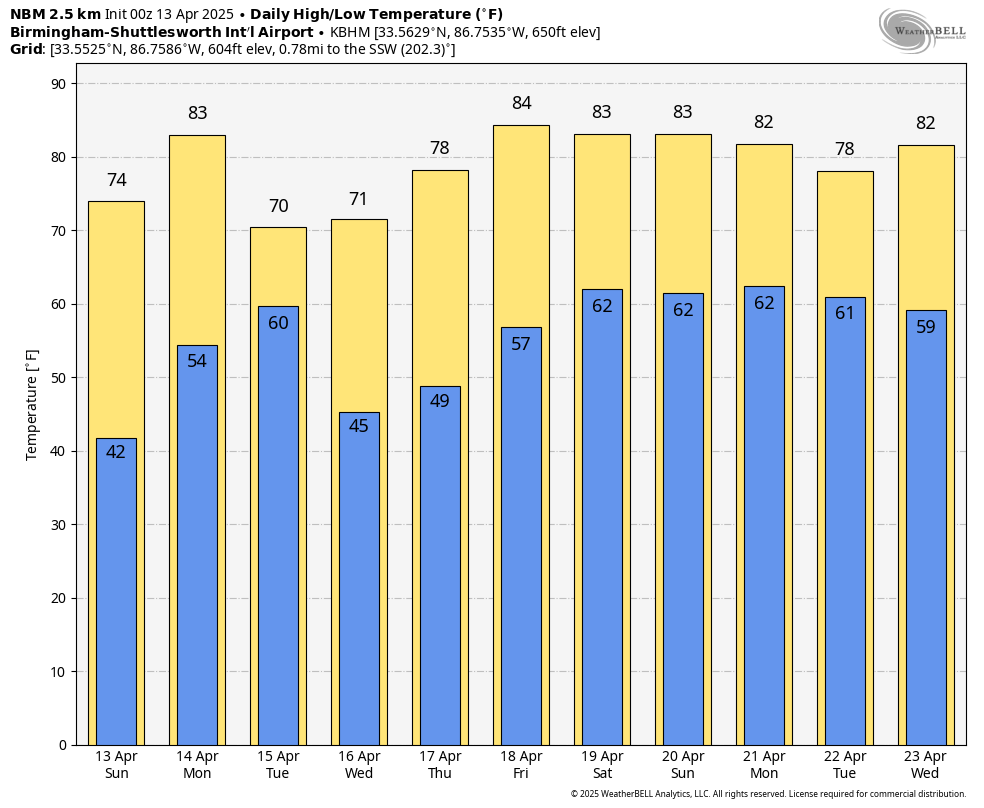
As Palm Sunday dawns across Alabama, it feels as if spring has finally settled in with confidence. The chill of early April mornings is still hanging on in some spots—especially in our northeastern valleys—but the sun is winning the battle. Skies are bright and blue across the state this morning as we head toward another classic spring afternoon. With high pressure anchored over the Southeast, today’s weather will be nothing short of glorious, whether you’re attending church, enjoying an Easter egg hunt, or enjoying a picnic with your sweetie. By mid-afternoon, highs will reach the mid to upper 70s under full sunshine, and winds will be light from the south. It’s a perfect Palm Sunday forecast.
SPANN TOLD YOU NOT TO PLANT UNTIL TAX DAY…
A frost advisory is in effect this morning for much of northeast and central Alabama, including areas like Scottsboro, Fort Payne, Anniston, Gadsden, and Sylacauga. Clear skies and calm winds overnight have allowed temperatures to drop into the mid 30s, creating favorable conditions for frost formation through 8 AM. Sensitive plants and early gardens may be at risk this morning if left uncovered. Always wise to wait til Tax Dy to plant in Alabama. Spann told you so! Fortunately, this looks like the last frost risk for a while. Sunshine will return quickly, and temperatures will rebound into the upper 60s and lower 70s by this afternoon.
CLEAR AND CALM TONIGHT
After a sun-filled and seasonably warm Sunday afternoon, clear skies will continue into tonight across all of Central and North Alabama. Temperatures will fall quickly after sunset, with overnight lows dipping into the low to mid 40s in the valleys and northeast counties, and upper 40s to near 50 degrees elsewhere. Winds will remain light out of the south or southeast, setting the stage for a pleasant spring evening. No rain is expected, and with the dry air still in place, it’s another good night for stargazing or enjoying the outdoors.
WARMING UP ON MONDAY
Monday brings a subtle shift in the pattern. The ridge that has been keeping our weather calm will begin to retreat as a cold front approaches from the northwest. While much of the day will remain dry and warm, with highs climbing into the low 80s, clouds will increase late in the afternoon and evening. A few scattered showers may develop Monday night as the front draws closer, especially north of Birmingham. Rainfall amounts should be light, and many locations may not see any rain at all until Tuesday morning.
STORMS TO OUR NORTH
The chance for anything stronger remains low for Alabama, but areas farther north—in parts of Ohio, Kentucky, and western Pennsylvania—will be dealing with stronger storms. There, the SPC is highlighting a risk for gusty winds and hail up to a half inch in diameter. Fortunately for us, the severe weather threat will remain well to our north.
BACK TO TUESDAY IN BAMA
Speaking of Tuesday, the front will move through during the early morning hours, bringing a brief window for a few more showers. Behind the front, cooler and drier air will settle in, giving us a beautiful Tuesday afternoon with sunshine returning and highs in the upper 60s to low 70s.
WEDNESDAY’S WINNING WEATHER
Wednesday looks like the pick of the week. It will be bright and comfortable, with highs once again in the low 70s and overnight lows dipping into the 40s. It’s shaping up to be an ideal spring day—great for gardening, grilling, or just enjoying the outdoors. Thursday brings a few more clouds, but temperatures continue to moderate, with highs climbing back into the upper 70s. Rain chances return late Thursday night, but at this point, coverage looks limited and showers should remain isolated.
FRIDAY’S FRONT
Friday brings the approach of another cold front, but it remains unclear whether it will make it into Alabama or stall to our north. We’ll call for a mix of sun and clouds and perhaps a few more showers by afternoon, with highs in the low to mid 70s. As of now, rainfall looks modest, and no severe weather is expected to end the work week.
EASTER WEEKEND PREVIEW
Looking ahead to Easter weekend, we’re cautiously optimistic. Models continue to suggest warm temperatures and mostly dry conditions on Saturday, with highs in the upper 70s and lows in the 50s. By Easter Sunday, a developing trough out west and a growing subtropical ridge to our east will begin their tug-of-war. This thumb-wrestling match could determine whether we stay dry or end up with more organized rain by Sunday night or Monday.
WEEK TWO TEASE
And peeking into week two? Well, things could get much more interesting. A pattern of strong Gulf moisture return, warmer-than-average sea surface temperatures in the Gulf of Mexico, and a stubborn subtropical ridge all point toward a wet and possibly stormy stretch as we enter the latter half of April. If a western trough locks in place, it could send multiple disturbances our way. While it’s too early to say if any of these will be severe, the calendar—and climatology—suggest the ingredients will be in place. It’s worth watching closely.
BEACH WEATHER BLISS
If you’re heading to the coast for spring break or Easter weekend, the beach forecast is just about perfect. Expect mostly sunny skies with highs in the upper 70s and lows in the 60s. A few isolated showers may pop up Thursday night or Friday, but the overall trend looks dry. The Gulf water temperature is running around 71–73 degrees, so it’s warm enough for a quick dip, especially for the brave. As always, check the latest rip current forecasts before you head into the surf.
FULL MOON GLOW
If you happened to step outside Saturday night, you likely noticed the Pink Moon glowing overhead. This full moon, the first of spring, is named for the moss pink wildflowers that bloom this time of year—not for its color. It rose just after sunset and illuminated the Alabama sky all night, casting a silvery glow over quiet fields and blooming dogwoods. With clear skies tonight, you’ll have another chance to enjoy its beauty before it begins to wane.
DANCIN’ WITH THE STATS
It was warm out West yesterday. Record highs included 85F at Provo (previous record 80F), Lubbock 96F (95F), Tucson 99F/96F, and Alamosa CO 79F/74F.
COMING UP ON WEATHERBRAINS
If you’re a fan of meteorology—or just interested in how weather forecasts are crafted—don’t miss this week’s episode of WeatherBrains. Monday night, we’re joined by Emmy-winning meteorologist and weather communications coach Tim Heller. With decades of broadcast experience, Tim brings insights into how weathercasters can better connect with their communities, especially during severe weather. It’s a can’t-miss conversation for anyone in weather or just fascinated by how forecasts are delivered.
APRIL 13TH IN WEATHER HISTORY
Finally, a bit of weather history: On April 13, 1857, a surprise late-season snow dusted parts of Alabama with up to 4 inches, part of an extraordinary April cold snap that brought measurable snow to every state in the U.S. It’s a reminder that while we’re basking in sunshine today, spring always has a few tricks up its sleeve.
Category: Alabama's Weather, ALL POSTS, Social Media
About the Author (Author Profile)
Bill Murray is the President of The Weather Factory. He is the site's official weather historian and a weekend forecaster. He also anchors the site's severe weather coverage. Bill Murray is the proud holder of National Weather Association Digital Seal #0001 @wxhistorianSubscribe
If you enjoyed this article, subscribe to receive more just like it.


