A Nice Weekend; No Severe Weather Threats Through the Next 7 Days
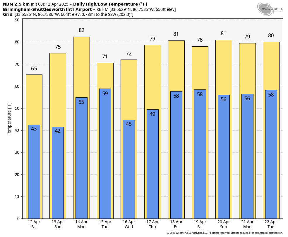
Latest run of the National Blend of Models showing potential highs and lows for the Birmingham Metropolitan Area. A little cooler if you go north, and a little warmer if you go south.
Good morning and happy Saturday. A quiet and stable weather pattern is expected across the state of Alabama for the next seven days, with no threat of severe weather anticipated during this period. Below is a detailed look at the forecast:
THIS WEEKEND: Today will be a textbook example of spring weather across Alabama. Under the influence of a strong surface high pressure system, skies will remain clear throughout the day. High temperatures will range from the lower 60s across the northern portions of the state to the mid 70s in southern areas. Winds will be breezy at times, with gusts up to 20 MPH possible. Dry and sunny conditions continue into Sunday. Morning lows will be on the cooler side, especially in northern counties, but temperatures will rebound nicely during the afternoon with highs ranging from the upper 60s to upper 70s. The persistent upper-level ridge will continue to suppress cloud development and maintain calm weather conditions.
THE WORK WEEK AHEAD: Temperatures begin to trend warmer on Monday as the upper ridge gradually shifts southeastward, and a southwest flow sets up. Highs are expected to climb into the upper 70s and may approach the low 80s in some southern locations. Sunshine will prevail through much of the day before cloud cover increases late in the afternoon ahead of an approaching cold front. An isolated shower cannot be ruled out, though the probability of measurable precipitation remains low.
On Tuesday, slightly cooler air arrives in the wake of Monday’s front, though conditions will remain pleasant. High temperatures will range from the upper 60s to upper 70s, and skies will gradually clear as surface high pressure reestablishes itself across the region. Another dry and seasonable day is expected on Wednesday. Abundant sunshine and light winds will accompany highs in the upper 60s to upper 70s across most areas.
On Thursday, cloud coverage may increase slightly during the day, though sunshine should still dominate. Temperatures will reach into the mid 70s to near 80 degrees. By late Thursday night, the ridge begins to weaken, and there is a low-end chance for isolated showers to develop after midnight. No significant rainfall is expected at this time. And, on Friday, partly cloudy skies and warm temperatures are on tap to close out the workweek. Highs will range from the mid 70s to mid 80s. While a few isolated showers may develop, the majority of the state is expected to remain dry.
THE BOTTOM LINE: A generally dry and mild stretch of spring weather is ahead, with ample sunshine and above-average temperatures. While isolated showers may develop late in the week, the overall risk of impactful weather remains low, and no severe weather is forecast. Stay tuned for updates, and enjoy the beautiful weather ahead.
SEVERE WEATHER SAFETY: Weather can be unpredictable, often catching us off guard with sudden changes. From thunderstorms and tornadoes to flash floods, being prepared can truly save lives. Alabama’s varied climate brings its share of severe weather, making it crucial for everyone to have a solid safety plan in place. For valuable tips on staying safe when severe weather threatens, check out our Severe Weather Safety Guide. Stay ready, stay safe!
BEACH FORECAST: Visit our Beach Forecast Center to get the latest weather and rip current forecasts for beaches from Fort Morgan to Panama City. This page allows you to select forecasts tailored to your destination, ensuring you have the most accurate and relevant information for your beach plans. Stay informed and safe on your coastal getaway!
ADVERTISE ON THE BLOG: Don’t miss this opportunity! Let us create a customized package tailored to the unique needs of your organization. Our solutions are creative, flexible, and competitively priced. For more information or inquiries, please contact Bill Murray at (205) 687-0782.
E-FORECAST SIGN UP: Get the Alabama Weather Blog’s comprehensive Seven-Day Forecast delivered straight to your inbox twice daily. Known as the most detailed forecast available in Central Alabama, our service ensures you’re always informed and prepared. Subscribe now and gain access to this valuable resource for free!
Category: Alabama's Weather, ALL POSTS, Social Media, Weather Xtreme Videos
About the Author (Author Profile)
Scott Martin is an operational meteorologist, professional graphic artist, musician, husband, and father. Not only is Scott a member of the National Weather Association, but he is also the Central Alabama Chapter of the NWA president. Scott is also the co-founder of Racecast Weather, which provides forecasts for many racing series across the USA. He also supplies forecasts for the BassMaster Elite Series events including the BassMaster Classic.Subscribe
If you enjoyed this article, subscribe to receive more just like it.


