Midday Nowcast: Clouds and Scattered Showers Possible this Afternoon; Wonderful Weekend Weather
WEATHER HODGEPODGE: A little bit of everything happening in Alabama today when it comes to the weather. The storms from last night allowed areas of patchy dense fog to develop this morning. That fog has mixed out through the morning hours, and we have been dealing with a mainly sunny sky late this morning.
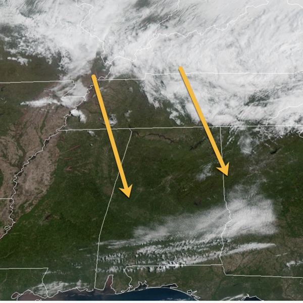
However, heading into the afternoon hours, we will be feeling a brisk northwest wind with clouds and scattered showers moving into and through the northern half of the state. These are associated with the deep upper trough moving through the Ohio Valley. The showers will be rather scattered and many of us will be staying dry. It is a cooler day with highs in the mid to upper 60s and low 70s down south. With the combination of showers and partly sunny skies this afternoon and evening, I would not be surprised to see several rainbows in the Alabama sky later today. The sky and showers will clear out of here early tonight. Tonight will be a chilly with lows in the upper 30s and lower 40s.
FOOTBALL FORECAST: The Birmingham Stallions are back in town for their first home game of the season tonight at Protective Stadium against the Arlington Renegades; 7PM kick off. There could be a few showers around downtown this evening, so take a rain jacket to be safe, but as the game continues the chance for showers will dwindle. It will be cool and breezy evening, with 58° at kick off and dropping into the lower 50s by the time the Stallions clinch the victory.
BIRMINGHAM ALMANAC: For April 11th, the average high for Birmingham is 74° and the average low is 51°. The record high is 86° set in 2011, while the record low is 26° set in 1973. We average 0.18” of precipitation on this date and the record value is 2.80” set in 1900.
ACROSS THE USA: Stormy weather from the Mid-Atlantic into New England, with late season accumulating snows possible in the higher elevations from northeast Pennsylvania into eastern New York and central to northern New England. Cold front moving through the West will bring chances for thunderstorms and enhanced fire risk to the Intermountain West and Plains. Record warmth expected through the weekend across the Southwest, GreatBasin, and Texas.
THE WEEKEND: Both days this weekend will be cool and dry across the Deep South. Lows will be mostly in the 40s, with highs in the 60s tomorrow and 70s Sunday. A picture perfect, spring weekend of weather for Alabama, and certainly great weather in Tuscaloosa and Auburn for all the A-Day festivities. First time in a while we haven’t had to deal with rain and strong storms at some point during a weekend.
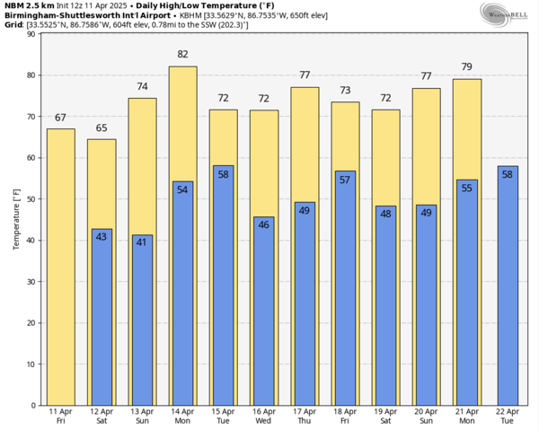
NEXT WEEK: Monday will be warm with highs in the 80s and plenty of sunshine. A weak cold front arrives late Monday and into Tuesday, it could bring a few showers, but this is not a major weather maker for us, but it will bring cooler temperatures. Expect highs in the 60s and 70s, with lows in the 40s and the rest of the week looks dry for now.
WORLD TEMPERATURE EXTREMES: Over the last 24 hours, the highest observation outside the U.S. was 111.2F at Nawabshah, Pakistan. The lowest observation was -107.0F at Vostok, Antarctica.
CONTIGUOUS TEMPERATURE EXTREMES: Over the last 24 hours, the highest observation was 104F at Rio Grande Village, TX. The lowest observation was 11F at Peter Sinks, UT.
Category: Alabama's Weather, ALL POSTS, Social Media
About the Author (Author Profile)
Macon, Georgia Television Chief Meteorologist, Birmingham native, and long time Contributor on AlabamaWX. Stormchaser. I did not choose Weather, it chose Me. College Football Fanatic. @Ryan_StinnetSubscribe
If you enjoyed this article, subscribe to receive more just like it.


