Midday Nowcast: Sunshine and Blue Sky Today; Storms Return Late Tomorrow
WONDERFUL WEDNESDAY: After the frosty start to the day, we are seeing temperatures surge into the 60s and 70s this afternoon. There is not a cloud in the sky over Central Alabama, and we are seeing blue sky and sunshine in full supply. Tonight will be another chilly one across the state, but most locations should be in the low and mid 40s. Tomorrow will be much warmer as highs surge into the mid and upper 70s. Most of tomorrow will be dry, but rain and storms arrive later tomorrow.
BIRMINGHAM ALMANAC: For April 9th, the average high for Birmingham is 74° and the average low is 50°. The record high is 89° set in 2011, while the record low is 30° set in 2000. We average 0.18” of precipitation on this date and the record value is 1.52” set in 2021.
RAIN/STORMS RETURN: A cold front will bring some scattered showers and thunderstorms to the state late tomorrow and tomorrow night. The Storm Prediction Center has increased to a level 2 of 5 “slight risk” of severe thunderstorms for areas along and north of Intestate 20, with a level 1 of 5 “marginal risk” south of there.
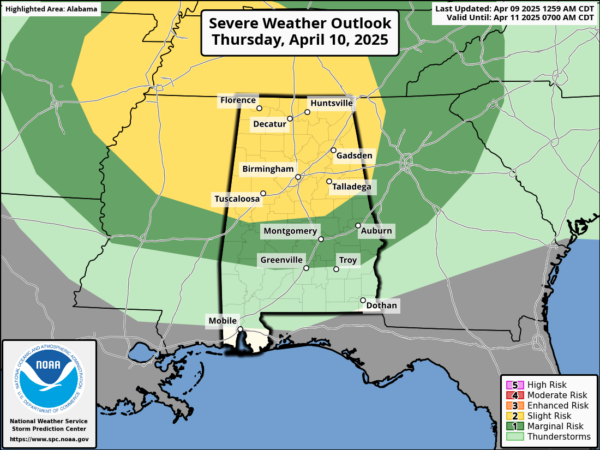
However, this is a low end threat as wind fields will not be particularly strong, but we will have to watch as some storms could produce hail and gusty winds. Tornado threat is very low, but not zero. Rain amounts will be less than one-half inch.
FRIDAY AND THE WEEKEND: Cooler air moves into the state Friday behind the front. The day will feature a gradually clearing sky with highs in the 60s. The weekend will be cool and dry across the Deep South. Lows will be mostly in the 40s, with highs in the 60s Saturday and 70s Sunday.
INTO NEXT WEEK: The calm weather pattern continues; much of the week will be dry. We will mention some risk of showers Tuesday with a cold front, but we see no risk of any heavy rain or severe storms. As another upper ridge builds in, we are likely to see highs return to the 80s.
WORLD TEMPERATURE EXTREMES: Over the last 24 hours, the highest observation outside the U.S. was 115.5F at Barmer, India. The lowest observation was -95.6F at Concordia, Antarctica.
CONTIGUOUS TEMPERATURE EXTREMES: Over the last 24 hours, the highest observation was 98F at Fortuna Foothills, AZ. The lowest observation was -6F at Grand Marais, MN.
Category: Alabama's Weather, ALL POSTS, Social Media
About the Author (Author Profile)
Macon, Georgia Television Chief Meteorologist, Birmingham native, and long time Contributor on AlabamaWX. Stormchaser. I did not choose Weather, it chose Me. College Football Fanatic. @Ryan_StinnetSubscribe
If you enjoyed this article, subscribe to receive more just like it.


