Nice Warm-Up Today; A Few Storms Late Tomorrow
COLD START: Here are some temperatures across Alabama just before sunrise this morning…
Cullman 30
Fort Payne 30
Haleville 30
Gadsden 31
Chelsea 31
Morris 31
Margaret 31
Hueytown 32
Jasper 34
Decatur 36
Birmingham 37
Muscle Shoals 37
Anniston 37
Huntsville 38
Tuscaloosa 38
Montgomery 43
Mobile 45
Dothan 46
With a sunny sky temperatures will rise into the 67-73 degree range across Alabama this afternoon.
STORMS RETURN: While most of the day tomorrow will be dry with a high in the 70s, a cold front will bring a few showers and storms to the state late in the day and tomorrow evening. SPC has defined a “slight risk” (level 2/5) of severe thunderstorms for North Alabama…
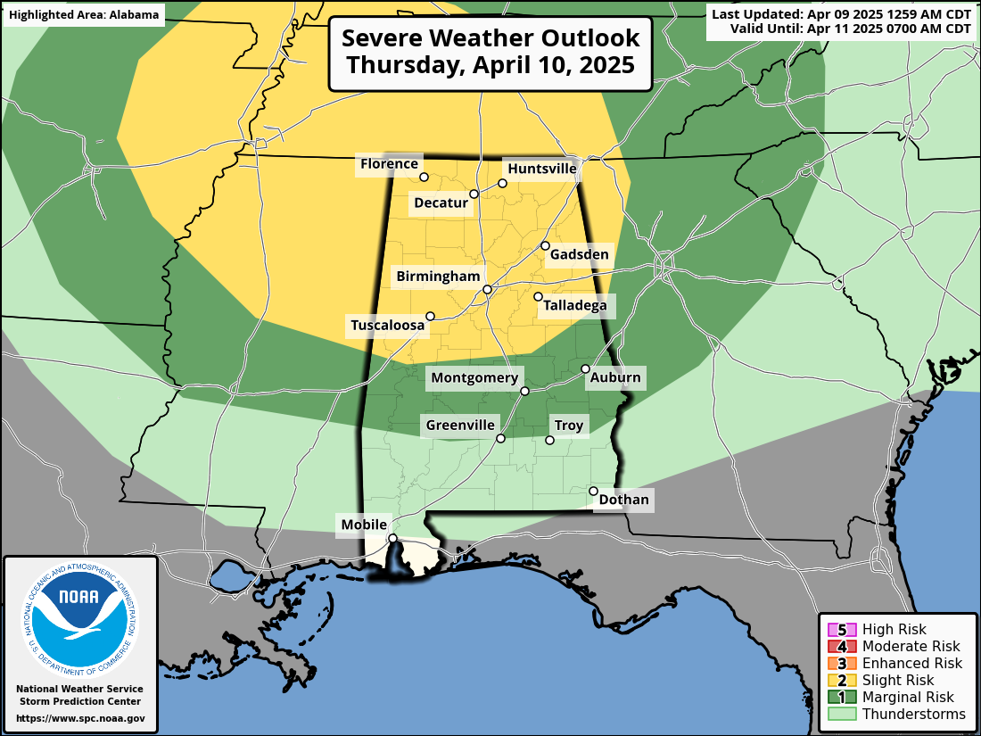
This is a low end severe weather threat as wind fields will be weak, but a few storms could produce small hail and gusty winds tomorrow evening over the northern half of the state.
Friday will be cooler with highs in the 60s. A passing upper trough could bring a few showers to the northern third of the state during the afternoon and evening hours, but rain amounts should be light.
THE ALABAMA WEEKEND: Expect a sun filled sky over the weekend… the high Saturday will be in the 60s, followed by 70s Sunday. Mornings will be cool with lows in the low to mid 40s; some colder spots over North Alabama could reach the upper 30s.
The weather next week looks relatively tame; we will mention the chance of a few showers Tuesday and Friday, but much of the week will be dry with seasonal temperatures. See the video briefing for maps, graphics, and more details.
ON THIS DATE IN 1947: An estimated F5 tornado struck Woodward, Oklahoma during the late evening killing 95 persons and causing six million dollars damage. The tornado, one to two miles in width, and traveling at a speed of 50 mph, killed a total of 167 persons along its 221-mile path from Texas into Kansas.
Look for the next video briefing here by 3:00 this afternoon… enjoy the day!
Category: Alabama's Weather, ALL POSTS, Weather Xtreme Videos
About the Author (Author Profile)
James Spann is one of the most recognized and trusted television meteorologists in the industry. He holds the AMS CCM designation and television seals from the AMS and NWA. He is a past winner of the Broadcast Meteorologist of the Year from both professional organizations.Subscribe
If you enjoyed this article, subscribe to receive more just like it.


