Sunday Evening Reset: Storms Winding Down Ahead of a Cool Snap
SEVERE THREAT ENDS FOR ALABAMA
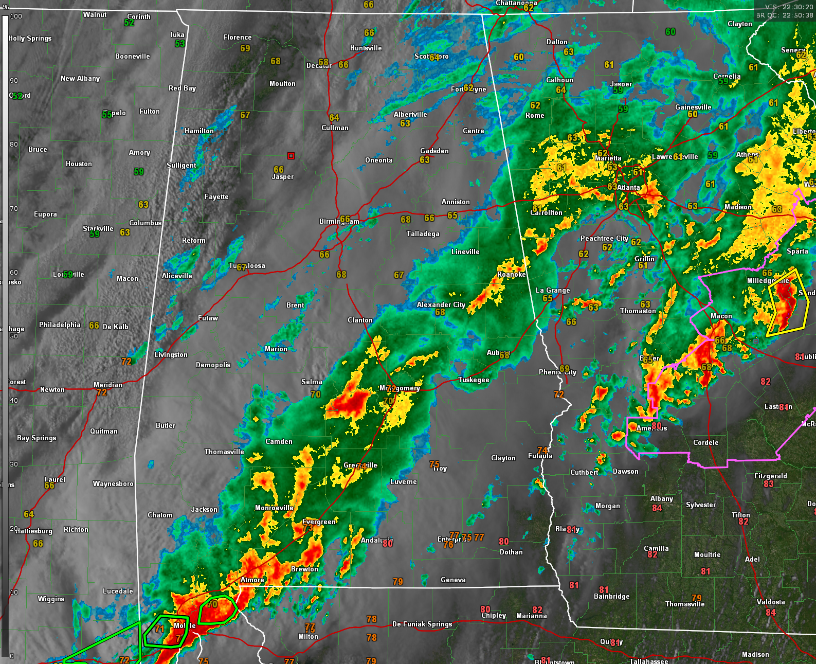
The severe weather threat has ended across Alabama this evening. Earlier storms packed damaging winds and isolated tornadoes across the state, but the atmosphere has now stabilized. The Storm Prediction Center officially trimmed back the risk area and allowed Tornado Watch 132 to expire at 5:20 PM, signaling the end of the threat for organized severe thunderstorms. The heavy rain threat has also begun to ease in western and northwestern Alabama, where the Flood Watch has now been canceled.
SHOWERS STILL LINGERING, MAINLY SOUTH AND EAST
While the worst is behind us, light to moderate showers remain ongoing across parts of east-central and southeast Alabama this evening. Additional rainfall of up to an inch is possible through the overnight hours, especially in areas like Auburn, Montgomery, and Troy. Some of these spots have already seen significant rainfall totals from earlier today, so runoff and localized flooding could still be a concern. A Flood Watch remains in effect for much of east-central Alabama through Monday evening, including Birmingham, Anniston, Tuscaloosa, and Auburn.
COOL FRONT USHERS IN DRIER AIR
A cold front is now moving steadily across the state, and behind it, a cooler and drier air mass is settling in. Temperatures are already falling into the 50s and lower 60s across northwest Alabama, and skies will slowly begin to clear overnight from northwest to southeast. Northerly winds will become breezy by daybreak, ushering in a refreshing change that will last several days.
DRIZZLE POSSIBLE MONDAY MORNING
Low clouds and areas of patchy drizzle will linger into Monday morning, especially across central and southern Alabama. While any measurable rainfall should be light, it may make for a damp start to the workweek. Temperatures Monday morning will start off in the 40s and lower 50s, with highs only reaching the upper 50s to mid 60s under mostly cloudy skies.
TURNING COLDER MONDAY NIGHT
As skies clear Monday evening, cold air advection will take hold. Overnight lows will fall into the upper 30s and lower 40s across much of the state, with a few pockets of frost possible in sheltered valleys of northern Alabama. But the coldest morning looks to be Wednesday, when widespread lows in the 30s could bring a risk of frost or even a light freeze across the northern half of the state.
A FEW NICE DAYS MIDWEEK
Tuesday and Wednesday will be cool, dry, and pleasant. Expect lots of sunshine both days, with highs generally ranging from the upper 50s to upper 60s—about 10 degrees below average for early April. Winds will be light, and the air will feel crisp and clean thanks to the Canadian high pressure building in from the north.
SHOWERS RETURN LATE WEEK
The next weather system arrives Thursday evening into Friday, bringing a chance of showers and perhaps a few rumbles of thunder. This system appears to be weak, and no severe weather is currently expected. Behind that front, another shot of cool air will arrive to close out the week, keeping temperatures below average through next weekend.
Category: Alabama's Weather, ALL POSTS, Severe Weather, Social Media
About the Author (Author Profile)
Bill Murray is the President of The Weather Factory. He is the site's official weather historian and a weekend forecaster. He also anchors the site's severe weather coverage. Bill Murray is the proud holder of National Weather Association Digital Seal #0001 @wxhistorianSubscribe
If you enjoyed this article, subscribe to receive more just like it.


