Severe Thunderstorm Warning Issued for Parts of Elmore, Lee, Macon & Tallapoosa Counties Until 1pm
The NWS has issued a severe thunderstorm warning for portions of the following counties: Elmore, Lee, Macon and Tallapoosa until 1pm. The main concern within these areas are damaging, 60mph wind gusts. A tornado is possible according to the NWS. If you are in this warning, seek shelter and remain vigilant for any further warnings.
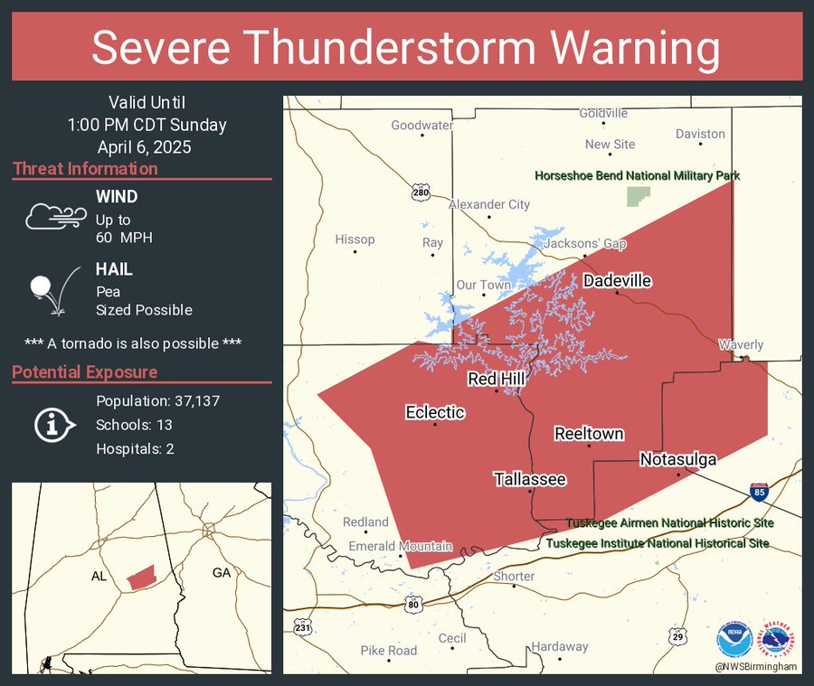
The National Weather Service in Birmingham has issued a

* Severe Thunderstorm Warning for...
  Eastern Elmore County in east central Alabama...
  Northwestern Lee County in east central Alabama...
  Northwestern Macon County in southeastern Alabama...
  Central Tallapoosa County in east central Alabama...

* Until 100 PM CDT.

* At 1152 AM CDT, severe thunderstorms were located along a line
  extending from Equality to near Eclectic to near Emerald Mountain,
  moving northeast at 35 mph.

  HAZARD...60 mph wind gusts.

  SOURCE...Radar indicated.

  IMPACT...Expect damage to roofs, siding, and trees.

* Locations impacted include...
  Eclectic, Martin Dam, Santuck, Camp Hill, Central, Loachapoka,
  Reeves Airport, Tallassee, Dadeville, Dare Park, Southern Lake
  Martin, Dexter, Yates Reservoir, Eastern Lake Martin, Claud,
  Susannah Crossing, Maxwell Gunter Recreation Area, Yates Dam,
  Liberty City, and Blue Creek Marina.

PRECAUTIONARY/PREPAREDNESS ACTIONS...

Remain alert for a possible tornado! Tornadoes can develop quickly
from severe thunderstorms. If you spot a tornado go at once into the
basement or small central room in a sturdy structure.
Category: Alabama's Weather, ALL POSTS, Severe Weather, Social Media
About the Author (Author Profile)
Scott is a senior at Mississippi State University studying professional and broadcast meteorology.Subscribe
If you enjoyed this article, subscribe to receive more just like it.


