Soaked and Stormy Sunday: Severe Weather, Flooding, and a Chill Behind
No video this morning because of continuing severe weather…
A STORMY START TO SUNDAY
A complex and impactful weather setup continues across Alabama this Sunday morning, with rounds of severe thunderstorms and flash flooding already in progress. A slow-moving line of strong to severe storms is crossing the state, producing damaging winds, heavy rainfall, and isolated tornadoes. Flash flood warnings are in effect across several counties in both north and central Alabama, and conditions will remain active through much of the day.
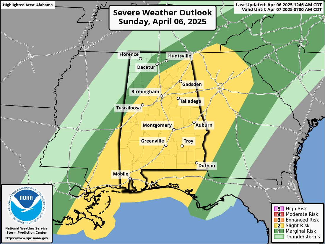
SEVERE WEATHER AND FLOODING THREAT
The SPC maintains a slight risk (level 2 of 5) for severe storms across Alabama today, including the risk of damaging winds, hail, and isolated tornadoes. A Flood Watch remains in effect for nearly all of Central and North Alabama through this evening. A tornado watch is in effect for all of Central Alabama until 10 a.m. The main concerns are damaging wind gusts along the line of storms, the potential for a few spin-up tornadoes within the QLCS structure, and localized flash flooding. Rainfall totals of 3 to 4 inches are likely in many areas, particularly between the I-20 and I-85 corridors, with localized amounts up to 6 inches where storms train repeatedly over the same locations.
THE SETUP
This storm system is driven by a combination of strong jet stream support aloft and an unusually warm and moist airmass at the surface. While the main upper-level energy is still well to the west, it is contributing to an unstable environment with CAPE values over 1000 J/kg and effective shear values supportive of embedded supercells.
SUNDAY’S WEATHER
Storms will continue throughout the morning hours, gradually pushing eastward across the state. Central Alabama will experience the most widespread activity between 5 a.m. and 2 p.m. Behind the main line, scattered showers and a few rumbles of thunder will persist into the afternoon, but the severe risk will diminish over time. Areas hardest hit by rainfall earlier in the day may see renewed flash flooding during the afternoon due to slow storm movement and saturated soils.
SUNDAY NIGHT OUTLOOK
Rain chances begin to taper off from west to east overnight Sunday into Monday morning. Cooler, drier air will begin to move into the state, setting the stage for a much calmer start to the new workweek. Skies will gradually clear, but some lingering clouds and patchy drizzle could remain in eastern areas before sunrise Monday.
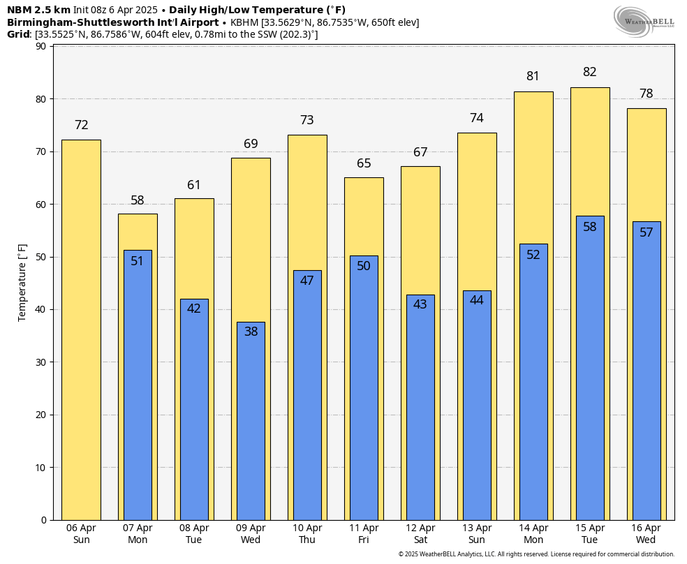
TURNING COLDER MONDAY
Temperatures will be noticeably cooler on Monday, with highs struggling to reach the upper 50s in many locations under mostly cloudy skies. A few lingering showers are possible early, but most of the day will be dry as northwesterly winds take hold. The cooler air is the leading edge of a pattern shift that will bring chilly mornings for much of the upcoming week.
COLD WEATHER AND FROST CONCERNS
Widespread frost and freeze conditions are expected Tuesday morning, especially in the northern half of Alabama. By Wednesday morning, freezing temperatures may reach as far south as central portions of the state. Sensitive plants and vegetation may be at risk, so residents should prepare accordingly. Highs will remain well below normal both Tuesday and Wednesday, with most areas staying in the 50s and 60s.
LATE WEEK RAIN AND STORMS
A new cold front will approach Alabama late Thursday into Friday, bringing another chance of showers and possibly a thunderstorm. However, the best dynamics with this system remain to the north, so severe weather is not expected at this time. The rain should move out quickly, and dry air will return behind the front just in time for the weekend.
FINE WEEKEND WEATHER AHEAD
If you’re making outdoor plans next weekend, you’re in luck. Saturday is shaping up to be sunny and pleasant, with highs in the upper 60s to lower 70s. Overnight lows will be cool but not as cold as earlier in the week. Overall, a welcome stretch of calm weather is expected following this active period.
BEACH FORECAST
Along the Alabama and Florida Gulf Coasts, rough surf and dangerous rip currents continue today through Monday. A high rip current risk and high surf advisory are in effect, with waves reaching 4 to 6 feet. Showers and thunderstorms are likely today and Monday, with highs in the upper 70s today and mid 60s Monday. Conditions will improve by Tuesday, with sunnier skies, lighter winds, and falling surf heights. Water temperatures are in the middle 70s.
WEATHERBRAINS NOTE
On the next episode of WeatherBrains, our guest will be author and disaster preparedness expert Ron Foster, who writes about survival in extreme weather scenarios such as hurricanes and solar flares. Joining us as a special guest panelist is climatologist Jared Rennie from the National Centers for Environmental Information, who will help connect real-world climate data to the scenarios Ron explores in his work. It’s sure to be a fascinating and thought-provoking discussion.
ON THIS DATE IN 2005
A deadly tornado outbreak struck Mississippi, with at least three long-track tornadoes. One tornado touched down near Mount Olive around 10:10 a.m. and moved into Smith County, hitting the Mize Attendance Center at 10:25 a.m. after students were moved to shelter. The tornado nearly destroyed the school, shearing away most of the second floor.
Category: Alabama's Weather, ALL POSTS, Severe Weather, Social Media
About the Author (Author Profile)
Bill Murray is the President of The Weather Factory. He is the site's official weather historian and a weekend forecaster. He also anchors the site's severe weather coverage. Bill Murray is the proud holder of National Weather Association Digital Seal #0001 @wxhistorianSubscribe
If you enjoyed this article, subscribe to receive more just like it.


