Severe Thunderstorm Warning for Northeast Alabama
BULLETIN – IMMEDIATE BROADCAST REQUESTED
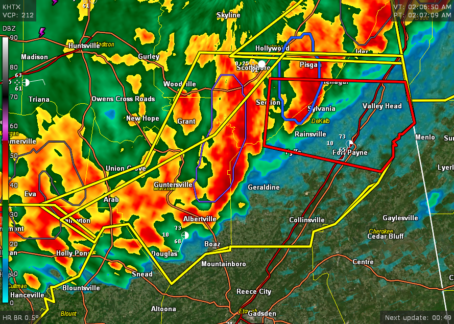
Severe Thunderstorm Warning
National Weather Service Huntsville AL
207 AM CDT Sun Apr 6 2025
The National Weather Service in Huntsville Alabama has issued a
* Severe Thunderstorm Warning for…
Marshall County in northeastern Alabama…
Southeastern Jackson County in northeastern Alabama…
DeKalb County in northeastern Alabama…
Northeastern Cullman County in north central Alabama…
* Until 300 AM CDT.
* At 207 AM CDT, severe thunderstorms were located along a line
extending from near Henagar to near Geraldine to near Strawberry,
moving east at 20 mph.
HAZARD…60 mph wind gusts.
SOURCE…Radar indicated.
IMPACT…Expect damage to roofs, siding, and trees.
* Locations impacted include…
High Point, Ider, Pine Ridge, Pisgah, Rosalie, Painter, Joppa,
Desoto State Park, Crossville, and Henagar.
PRECAUTIONARY/PREPAREDNESS ACTIONS…
Remain alert for a possible tornado! Tornadoes can develop quickly
from severe thunderstorms. If you spot a tornado go at once into the
basement or small central room in a sturdy structure.
For your protection move to an interior room on the lowest floor of a
building.
Torrential rainfall is occurring with these storms, and may lead to
flash flooding. Do not drive your vehicle through flooded roadways.
A Tornado Watch remains in effect until 300 AM CDT for north central
and northeastern Alabama.
Category: Alabama's Weather, ALL POSTS, Severe Weather, Social Media
About the Author (Author Profile)
Bill Murray is the President of The Weather Factory. He is the site's official weather historian and a weekend forecaster. He also anchors the site's severe weather coverage. Bill Murray is the proud holder of National Weather Association Digital Seal #0001 @wxhistorianSubscribe
If you enjoyed this article, subscribe to receive more just like it.


