Severe Thunderstorm Warning for Jackson and DeKalb Counties
BULLETIN – IMMEDIATE BROADCAST REQUESTED
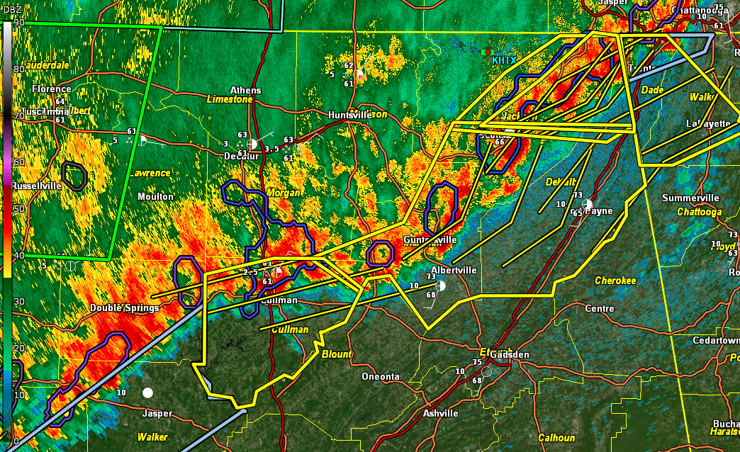
Severe Thunderstorm Warning
National Weather Service Huntsville AL
154 AM CDT Sun Apr 6 2025
The National Weather Service in Huntsville Alabama has issued a
* Severe Thunderstorm Warning for…
Northeastern Jackson County in northeastern Alabama…
Northeastern DeKalb County in northeastern Alabama…
* Until 245 AM CDT.
* At 153 AM CDT, severe thunderstorms were located along a line
extending from near Trenton to near Ider to near Pisgah, moving
east at 50 mph.
HAZARD…60 mph wind gusts.
SOURCE…Radar indicated.
IMPACT…Expect damage to roofs, siding, and trees.
* Locations impacted include…
Bridgeport, Hollywood, Martintown, Rosalie, Long Island, Fabius,
Higdon, Sulpher Springs, Fackler, and Ider.
PRECAUTIONARY/PREPAREDNESS ACTIONS…
Remain alert for a possible tornado! Tornadoes can develop quickly
from severe thunderstorms. If you spot a tornado go at once into the
basement or small central room in a sturdy structure.
For your protection move to an interior room on the lowest floor of a
building.
Large hail, damaging wind, and continuous cloud to ground lightning
are occurring with these storms. Move indoors immediately. Lightning
is one of nature’s leading killers. Remember, if you can hear
thunder, you are close enough to be struck by lightning.
A Tornado Watch remains in effect until 300 AM CDT for north central
and northeastern Alabama.
Category: Alabama's Weather, ALL POSTS, Severe Weather, Social Media
About the Author (Author Profile)
Bill Murray is the President of The Weather Factory. He is the site's official weather historian and a weekend forecaster. He also anchors the site's severe weather coverage. Bill Murray is the proud holder of National Weather Association Digital Seal #0001 @wxhistorianSubscribe
If you enjoyed this article, subscribe to receive more just like it.


