A New Tornado Warning and a New Severe Thunderstorm Warning in North Alabama
The most dangerous storm is near New Hope in southern Madison County moving east southeast into Marshall County approaching Lake Guntersville.
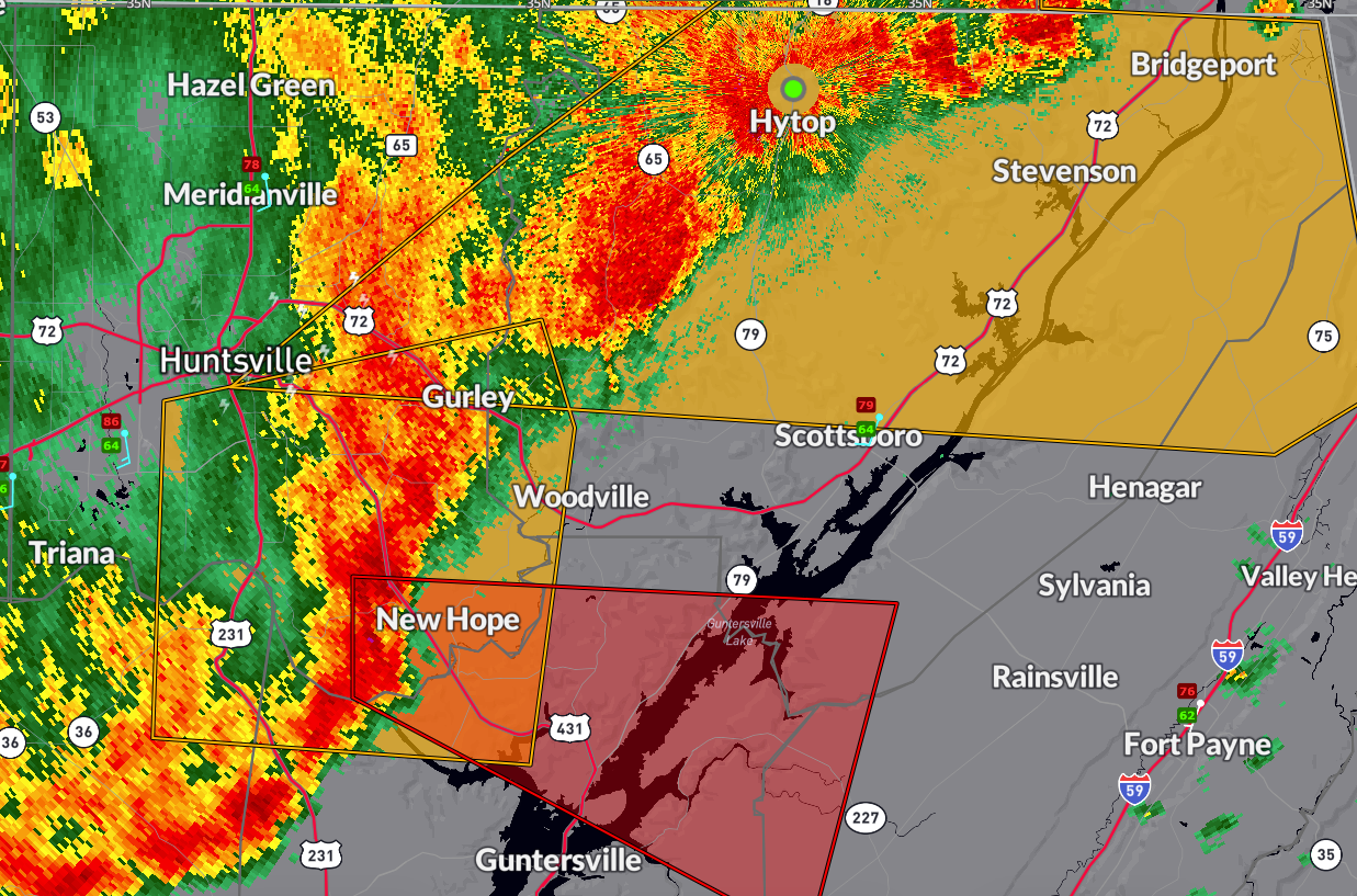
BULLETIN – EAS ACTIVATION REQUESTED
Tornado Warning
National Weather Service Huntsville AL
116 AM CDT Sun Apr 6 2025
The National Weather Service in Huntsville Alabama has issued a
* Tornado Warning for…
Northern Marshall County in northeastern Alabama…
Southern Jackson County in northeastern Alabama…
Southeastern Madison County in north central Alabama…
West central DeKalb County in northeastern Alabama…
* Until 200 AM CDT.
* At 116 AM CDT, a severe thunderstorm capable of producing a tornado
was located near Owens Cross Roads, or 13 miles north of Arab,
moving east at 35 mph.
HAZARD…Tornado.
SOURCE…Radar indicated rotation.
IMPACT…Flying debris will be dangerous to those caught without
shelter. Mobile homes will be damaged or destroyed.
Damage to roofs, windows, and vehicles will occur. Tree
damage is likely.
* This dangerous storm will be near…
Grant around 130 AM CDT.
Other locations impacted by this tornadic thunderstorm include
Painter, Langston, Whiton, Columbus City, Hopewell, and Lake
Guntersville St Park.
PRECAUTIONARY/PREPAREDNESS ACTIONS…
TAKE COVER NOW! Move to a basement or an interior room on the lowest
floor of a sturdy building. Avoid windows. If you are outdoors, in a
mobile home, or in a vehicle, move to the closest substantial shelter
and protect yourself from flying debris.
&&
BULLETIN – IMMEDIATE BROADCAST REQUESTED
Severe Thunderstorm Warning
National Weather Service Huntsville AL
104 AM CDT Sun Apr 6 2025
The National Weather Service in Huntsville Alabama has issued a
* Severe Thunderstorm Warning for…
Jackson County in northeastern Alabama…
East central Madison County in north central Alabama…
Northeastern DeKalb County in northeastern Alabama…
Southeastern Franklin County in Middle Tennessee…
* Until 200 AM CDT.
* At 103 AM CDT, severe thunderstorms were located along a line
extending from 9 miles southeast of Cowan to near Skyline to near
Gurley, moving east at 45 mph.
HAZARD…60 mph wind gusts.
SOURCE…Radar indicated.
IMPACT…Expect damage to roofs, siding, and trees.
* Locations impacted include…
Jericho, Higdon, Ider, Larkin, Bridgeport, Pisgah, Rosalie, Ryland,
Larkinsville, and Bass.
PRECAUTIONARY/PREPAREDNESS ACTIONS…
Remain alert for a possible tornado! Tornadoes can develop quickly
from severe thunderstorms. If you spot a tornado go at once into the
basement or small central room in a sturdy structure.
For your protection move to an interior room on the lowest floor of a
building.
Large hail, damaging wind, and continuous cloud to ground lightning
are occurring with these storms. Move indoors immediately. Lightning
is one of nature’s leading killers. Remember, if you can hear
thunder, you are close enough to be struck by lightning.
A Tornado Watch remains in effect until 300 AM CDT for north central
and northeastern Alabama…and Middle Tennessee.
&&
LAT…LON 3466 8565 3471 8659 3488 8634 3511 8596
3511 8586 3499 8586 3498 8561 3471 8555
TIME…MOT…LOC 0603Z 268DEG 37KT 3505 8591 3487 8617 3473 8642
TORNADO…POSSIBLE
HAIL THREAT…RADAR INDICATED
MAX HAIL SIZE…<.75 IN
WIND THREAT...RADAR INDICATED
MAX WIND GUST...60 MPH
$$
AMP
Category: Alabama's Weather, ALL POSTS, Severe Weather, Social Media
About the Author (Author Profile)
Bill Murray is the President of The Weather Factory. He is the site's official weather historian and a weekend forecaster. He also anchors the site's severe weather coverage. Bill Murray is the proud holder of National Weather Association Digital Seal #0001 @wxhistorianSubscribe
If you enjoyed this article, subscribe to receive more just like it.


