New Severe Thunderstorm Warning for North Alabama; General Update
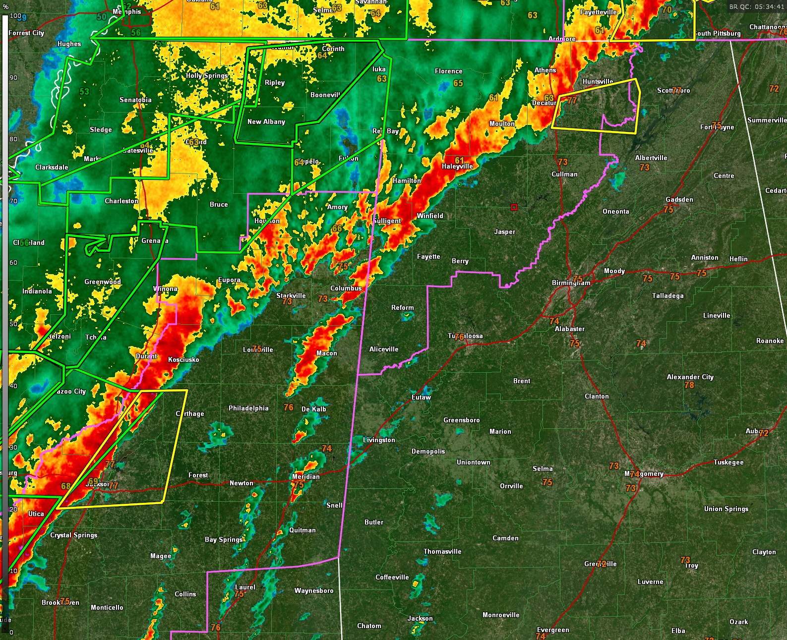
A severe thunderstorm warning is in effect until 1:30 AM for parts of Madison, Morgan, Limestone, Marshall, and Jackson counties in north Alabama. At 12:33 AM, a severe storm near Priceville was moving east at 30 mph with the potential for 60 mph wind gusts. This storm could cause damage to roofs, siding, and trees. Locations impacted include Redstone Arsenal, Hampton Cove, Triana, and Gurley. Stay alert — while this is not currently a tornado-warned storm, tornadoes can form quickly from severe thunderstorms. A tornado watch remains in effect until 3:00 AM.
Things had briefly calmed down across the state, but storm activity is ramping back up as a powerful squall line approaches from Mississippi. The line, which stretches from eastern Louisiana through central Mississippi, is organizing and accelerating eastward. While one storm east of Jackson remains warned for a tornado, other storms have also fired along an outflow boundary ahead of the main line. These are not severe yet, but they are being closely monitored.
The environment remains favorable for damaging winds and embedded tornadoes as storms move into Alabama overnight. Areas of concern include western and central Alabama, where additional watches and warnings may be issued before sunrise. The threat includes damaging straight-line winds and the possibility of a strong tornado or two, particularly with any discrete cells that develop ahead of the line.
If you’re in areas from Tuscaloosa to Birmingham and into eastern and southern parts of the state, don’t let the quiet moments lull you. Storms are already active again in north Alabama and more are coming. Make sure you have multiple ways to receive warnings — especially if you’re sleeping — and be ready to act quickly if a warning is issued for your area.
Category: Alabama's Weather, ALL POSTS, Severe Weather, Social Media
About the Author (Author Profile)
Bill Murray is the President of The Weather Factory. He is the site's official weather historian and a weekend forecaster. He also anchors the site's severe weather coverage. Bill Murray is the proud holder of National Weather Association Digital Seal #0001 @wxhistorianSubscribe
If you enjoyed this article, subscribe to receive more just like it.


