Tornado Coming into Florence!
Our friends at the Tennessee Valley Weather Channel have observed power flashes on their UNA cam as a tornado crosses the Tennessee River near Woodland making a beeline for Florence, Alabama.
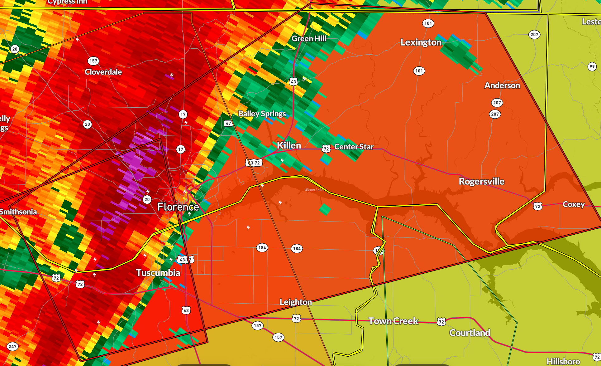
Tornado debris signature forming and mre power flashes.
BULLETIN – EAS ACTIVATION REQUESTED
Tornado Warning
National Weather Service Huntsville AL
1026 PM CDT Sat Apr 5 2025
The National Weather Service in Huntsville Alabama has issued a
* Tornado Warning for…
West central Limestone County in north central Alabama…
Eastern Lauderdale County in northwestern Alabama…
Southeastern Colbert County in northwestern Alabama…
North central Lawrence County in northwestern Alabama…
* Until 1115 PM CDT.
* At 1026 PM CDT, a confirmed tornado was located over Sheffield,
moving east at 40 mph.
HAZARD…Damaging tornado.
SOURCE…Broadcast media confirmed tornado.
IMPACT…Flying debris will be dangerous to those caught without
shelter. Mobile homes will be damaged or destroyed.
Damage to roofs, windows, and vehicles will occur. Tree
damage is likely.
* The tornado will be near…
Sheffield, Tuscumbia, Florence, and Muscle Shoals around 1030 PM
CDT.
St. Florian around 1035 PM CDT.
Killen around 1040 PM CDT.
Lexington around 1055 PM CDT.
Other locations impacted by this tornadic thunderstorm include Green
Hill, Northwest Alabama Regional Airport, Coxey, Oliver, New Bethel,
Oakland, Anderson, Center Star, Pride Landing, and Kingtown.
Category: Alabama's Weather, ALL POSTS, Severe Weather, Social Media
About the Author (Author Profile)
Bill Murray is the President of The Weather Factory. He is the site's official weather historian and a weekend forecaster. He also anchors the site's severe weather coverage. Bill Murray is the proud holder of National Weather Association Digital Seal #0001 @wxhistorianSubscribe
If you enjoyed this article, subscribe to receive more just like it.


