Here is an Alabama Update at 4:35 p.m.: Tornado Watch Possible Next Few Hours for West Central Alabama
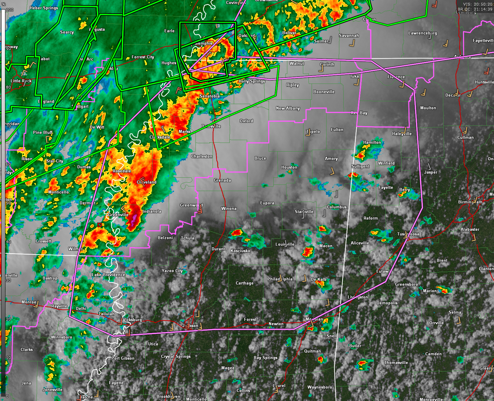
A broken line of storms with embedded supercells continues advancing into eastern Arkansas and western Mississippi, and a new Tornado Watch is likely to be issued shortly for northeast Louisiana, northern and central Mississippi, and parts of northwest Alabama. The environment ahead of the line is primed for severe weather, with MLCAPE values around 2500 J/kg and effective bulk shear of 50–60 knots. Although low-level shear is somewhat limited for now due to daytime mixing, it is expected to increase later this evening as the low-level jet strengthens, supporting the potential for damaging winds, large hail, and possibly a few tornadoes—especially as bowing segments organize across northern Mississippi.
Meanwhile, scattered showers have developed further east into central Mississippi, where the atmosphere remains very moist and uncapped. Most of this activity is shallow, with limited lightning so far, but a few deeper cells are showing lightning now near eastern Mississippi, suggesting they’re starting to tap into the instability. Should one or more of these storms organize into discrete supercells, the environment would support all severe hazards, including the risk of a strong tornado. The timing and development of this activity will determine whether an additional tornado watch is issued sooner across this region.
Locally across northwest Alabama, some showers and thunderstorms are developing in the western counties, but high cloud bases (high LCLs) are limiting the tornado threat for now. While the overall risk appears low through sunset, some storms could look visually intense, and wall clouds or scary-looking formations could trigger photos and social media chatter. Model guidance like WoFS suggests stronger storms currently northwest of the area may push southeast into Marion County after 8 PM, but the early orientation of the line is not favorable for tornadic development. However, this could evolve as the evening progresses and shear increases.
Category: Alabama's Weather, ALL POSTS, Severe Weather, Social Media
About the Author (Author Profile)
Bill Murray is the President of The Weather Factory. He is the site's official weather historian and a weekend forecaster. He also anchors the site's severe weather coverage. Bill Murray is the proud holder of National Weather Association Digital Seal #0001 @wxhistorianSubscribe
If you enjoyed this article, subscribe to receive more just like it.


