Warm, Breezy, and Humid Start Across Alabama Ahead of Approaching Storms
It is a beautiful morning across Alabama with partly cloudy skies and balmy conditions. Skies are partly to mostly cloudy across Alabama this morning with temperatures ranging from the upper 60s to mid 70s, and a blanket of humidity making it feel warm and sticky statewide; southerly winds are picking up, especially near the coast, where Mobile and Brookley Field are reporting gusts and low clouds ahead of the approaching front, while areas from Huntsville to Montgomery are already climbing through the low 70s under filtered sunshine.
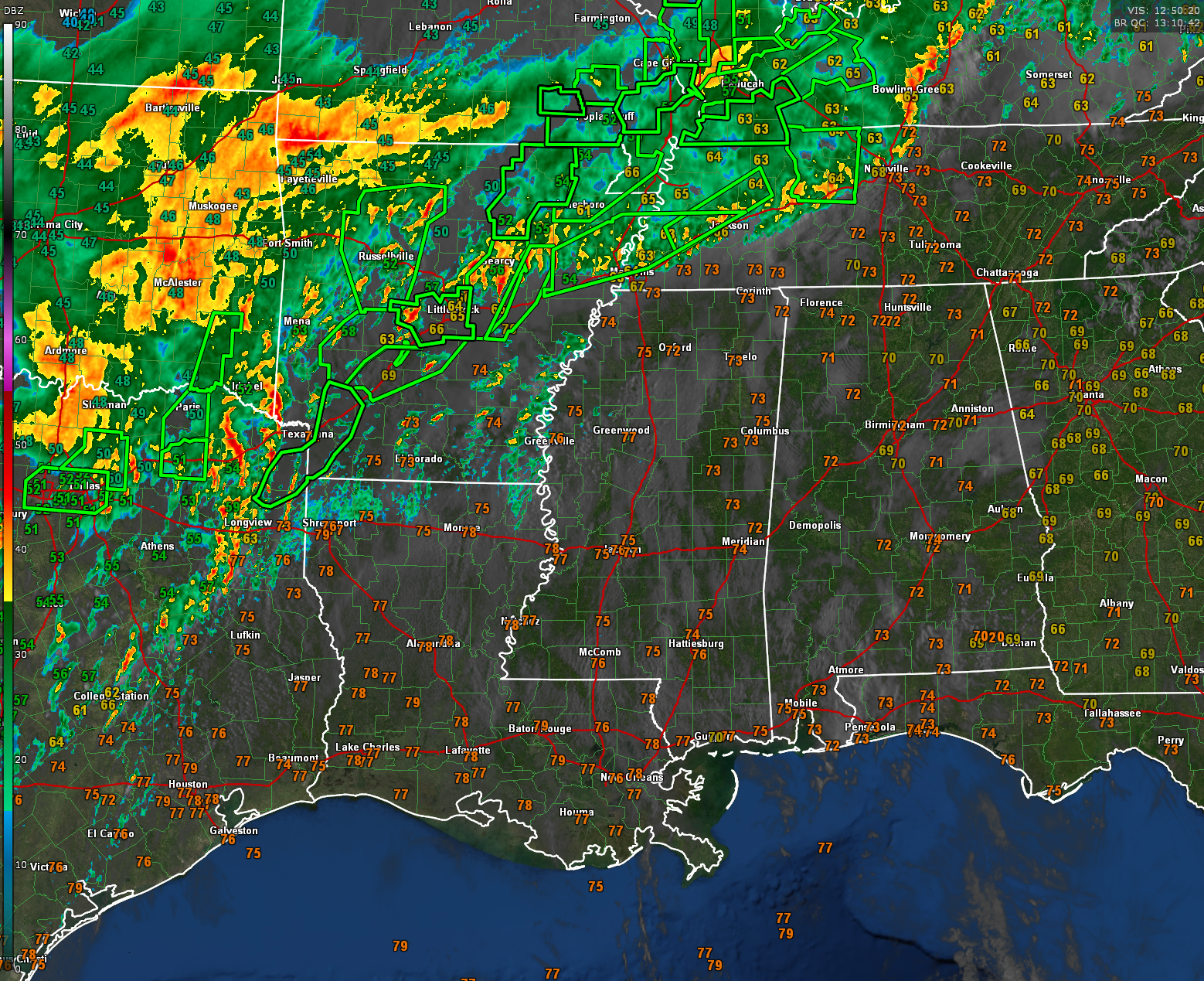
Nearly 30 flash flood warnings blanket the area from North Texas through southeastern Oklahoma, Arkansas, southeastern Missouri, western Tennessee, western Kentucky, and southern Illinois. There are even 6 considerable threat flash flood warnings and one flash flood emergency in effect. There have been a couple of tornado warnings this well as well.
There is even a PDS Flood Watch from southern Illinois and Indiana through western Kentucky and Tennessee, into southeastern Missouri and much of Arkansas.
SEVERE WEATHER THREAT RATCHETS UP TODAY
A dangerous round of storms is still expected later today and into Sunday across Alabama and much of the Deep South. The Storm Prediction Center has outlined an Enhanced Risk (Level 3 of 5) for areas from East Texas to the Tennessee Valley. Here is the latest Day One issued by the SPC:
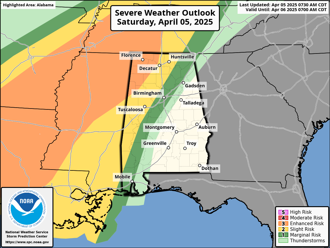
The level 3/5 risk just touches Northwest late tonight. The slight risk (level 2/5) extends as far east as Huntsville, Cullman, Tuscalosa, Demopolis, and Chatom, including places like the named cities and Fayette, Jasper, Hamilton, Muscle Shoals, and Decatur. The level 1/5 risk extends to Scottsboro, Arab, Birmingham, Marion and Thomasville.
Here in Alabama, storms are expected to begin developing late tonight—after sunset—mainly across the western counties, before spreading eastward into Sunday morning and afternoon. All modes of severe weather are possible, including damaging winds, large hail, and isolated tornadoes. The tornado threat will be greatest with any discrete storms that form ahead of the main line, especially over western Alabama late tonight.
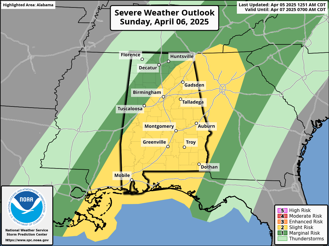
The threat continues into tomorrow as the line of storms shifts southeastward throughout the day with the main risk area covering areas generally along and south of I-59 from 7 a.m. and on.
HOT TODAY BEFORE THE STORMS ARRIVE
Temperatures will once again soar into the upper 80s today, with some locations threatening to hit 90 degrees for a second straight day. That heat, combined with strong southerly winds and dewpoints in the 60s, is helping to create a volatile atmosphere. Conditions remain capped for most of the day, meaning we expect little to no thunderstorm development until the evening hours. Winds will be gusty from the south at 15 to 25 mph, especially in the afternoon.
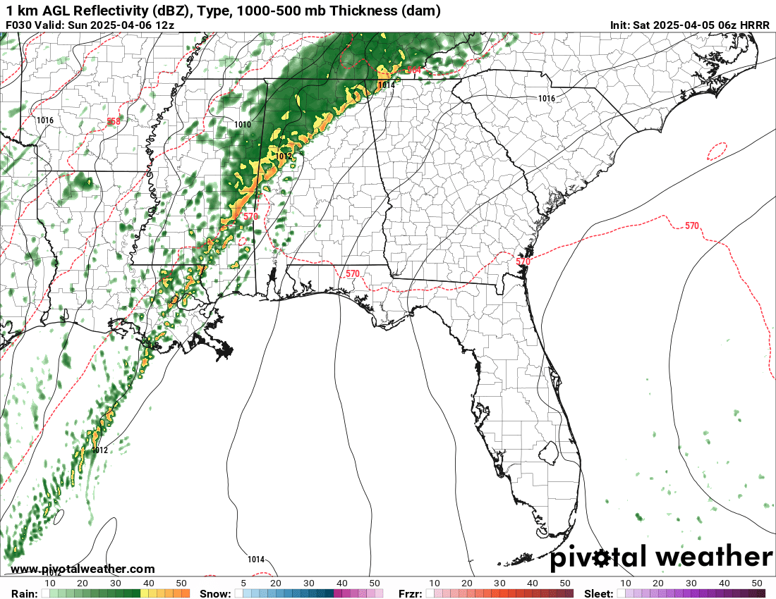
Projected radar from 06z HRRR model
TONIGHT: LINE OF STORMS PUSHES EAST
Storms will begin to move into western Alabama around midnight tonight as a line associated with a cold front pushes eastward. A strengthening low-level jet and rich Gulf moisture will support a robust squall line, with embedded circulations and possibly some supercell structures ahead of the main line. Damaging straight-line winds are the most likely hazard, but there is sufficient low-level shear to support the risk of a tornado or two. The line will be slow-moving, which increases the threat for heavy rainfall and localized flash flooding overnight into Sunday morning.
SUNDAY: STORMS SLOWLY EXIT, THEN THE TEMPERATURES PLUNGE
On Sunday, the line of storms will continue to progress eastward, reaching the I-65 corridor by late morning and gradually moving into eastern and southern Alabama through the afternoon. Severe weather will remain possible into the early afternoon, especially across southeastern parts of the state where instability may linger longer. Rain totals of 2 to 4 inches are likely, with some locally higher amounts, and flash flooding is a concern. Behind the front, much cooler air will rush in. Highs on Sunday may only reach the low 70s in the east and could remain in the 60s to the west, with overnight lows dropping into the 40s.
BIG COOL-DOWN AND FROST CONCERNS EARLY NEXT WEEK
The post-frontal airmass will bring an early taste of springtime chill. Monday will be cool with highs in the 50s to near 60. But Tuesday and Wednesday mornings bring the potential for widespread frost and a light freeze in the northern half of Alabama. Lows could dip into the low to mid 30s, so gardeners and growers should prepare to protect sensitive vegetation. We’ll be watching this closely and provide updates if any frost or freeze alerts are issued.
Category: Alabama's Weather, ALL POSTS, Severe Weather, Social Media
About the Author (Author Profile)
Bill Murray is the President of The Weather Factory. He is the site's official weather historian and a weekend forecaster. He also anchors the site's severe weather coverage. Bill Murray is the proud holder of National Weather Association Digital Seal #0001 @wxhistorianSubscribe
If you enjoyed this article, subscribe to receive more just like it.


