Rain/Storms Return To Alabama Sunday; Colder Next Week
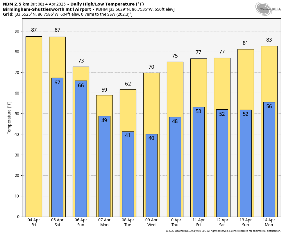
SUMMER PREVIEW CONTINUES: We are forecasting highs in the mid to upper 80s across Alabama today and tomorrow, very close to record levels for early April. While an isolated shower or storm is possible during the afternoon and evening hours, most of the state will stay dry under a strong upper ridge. The risk of severe storms and heavy rain will remain north and west of Alabama through tomorrow evening.
The ridge will break down over the weekend, and this will allow rain and storms to move into the state after midnight tomorrow night into the day Sunday. SPC has most all of Alabama in a severe weather risk.
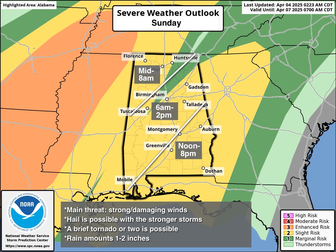
Models suggest the band of showers and storms will arrive around midnight tomorrow night over the northwest corner of the state with only a slow southward movement. The storms will reach the Birmingham metro by late morning, then shifting into South Alabama during the afternoon and evening hours. The main concern will come from hail and strong, gusty winds. But, with the slower progression across the state, the air could become unstable over the southern counties by Sunday afternoon where a tornado or two will be possible. Rain amounts Sunday will be in the 1-2 inch range for much of Alabama.
NEXT WEEK: The weather will be much cooler. Expect a clearing sky Monday; temperatures won’t get out of the 50s over the northern third of the state. Morning lows will be in the 30s over most of North Alabama Tuesday and Wednesday morning with potential for frost; some of the colder spots could see a late season freeze. Most of the week will be dry, although a disturbance could bring a few light showers to the northern counties Thursday. See the video briefing for maps, graphics, and more details.
ON THIS DATE IN 1977: A violent F5 tornado tore through the northern part of Birmingham. It began around 3 pm, 4 miles northwest of downtown Birmingham near U.S. Highway 78, and then traveled northeast for 15 miles at 60 mph, crossing Interstate 65. At its widest point, the tornado was 3/4 of a mile wide. Over 150 homes were damaged with almost 50 completely destroyed; the Smithfield neighborhood was especially hard hit. A total of 22 people were killed with over 130 injured. There were six other tornadoes on this day including five F2 tornadoes and an F3 tornado across North and Central Alabama.
The same thunderstorm complex was responsible for the crash of Southern Airways Flight 242 in Georgia; it was a flight from Huntsville to Atlanta. The passenger jet went down after suffering hail damage and losing thrust on both engines; Sixty-three people on the aircraft (including the flight crew) and nine people on the ground died; twenty passengers survived, as well as the two flight attendants. One of the initial survivors succumbed to his injuries several weeks later.
Look for the next video update here by 3:00 this afternoon… enjoy the day!
Category: Alabama's Weather, ALL POSTS, Weather Xtreme Videos
About the Author (Author Profile)
James Spann is one of the most recognized and trusted television meteorologists in the industry. He holds the AMS CCM designation and television seals from the AMS and NWA. He is a past winner of the Broadcast Meteorologist of the Year from both professional organizations.Subscribe
If you enjoyed this article, subscribe to receive more just like it.


