Severe Weather Ramping up to the North of Alabama; Tornado Warning for Areas Near Franklin, TN
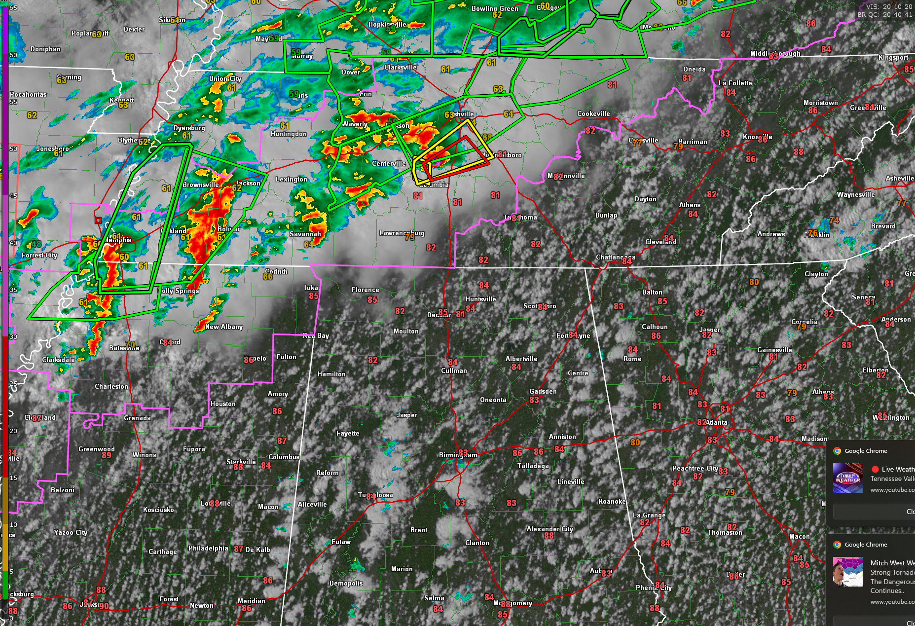
An increasingly volatile severe weather setup is unfolding this afternoon across portions of the Lower Mississippi Valley and into the Tennessee Valley. A large area is already under multiple Tornado and Severe Thunderstorm Watches, with the greatest threat concentrated from northeast Texas through Arkansas and northern Mississippi into western and middle Tennessee. Storms are organizing along a stalled frontal boundary where moisture-rich, unstable air is surging northward beneath powerful upper-level winds. This setup favors the development of supercells capable of producing very large hail, damaging winds, and strong tornadoes, particularly near the frontal zone where low-level shear is maximized.
One such storm has already intensified rapidly west of Spring Hill, Tennessee, and is now pushing toward Thompson’s Station and the I-840 corridor south of Nashville. This storm is producing very large hail and has prompted a new tornado warning. The radar is showing a three body scatter spike, which is a clear indication of large hail.
Additional showers are beginning to bubble up in the strong southerly flow over Alabama, but most of Central Alabama remains capped and dry under the influence of a strong subtropical ridge. Still, isolated storms can’t be ruled out in far western counties where the cap is weaker and moisture is deeper.
In North Alabama, a similar setup is in place with the Tennessee Valley caught between an eastward-stalled front to the west and the persistent influence of high pressure to the east. For now, the bulk of the severe activity should stay west of I-65, but a few showers or storms could sneak into northwest Alabama later this afternoon. If they do break through the cap, they’ll enter an environment very supportive of all severe weather hazards—including tornadoes, large hail, and damaging winds. Meanwhile, temperatures are surging into the mid-to-upper 80s across the area, threatening daily records at both Muscle Shoals and Huntsville. Breezy southerly winds will persist into tonight, keeping the air warm and humid as we head toward a more active weekend.
As we move through the afternoon and evening, storms will continue to fire along and just north of the stalled boundary, tracking eastward across the region. The Storm Prediction Center maintains an Enhanced Risk (Level 3 of 5) for severe storms from northeast Texas to middle Tennessee and southern Kentucky, where supercells with large to very large hail (1.5–2.5 inches), damaging winds, and a few strong tornadoes (EF2+) will be possible. Even elevated storms north of the boundary may still produce large hail and gusty winds, but it’s the surface-based storms in the warm sector that carry the greatest risk.
Central Alabama remains on the warm and dry side of this system—for now. The dominant ridge aloft is keeping rain chances limited today and tomorrow, with record-breaking high temperatures again approaching or exceeding 90 degrees. A few showers have managed to develop along the western fringe of the state, and isolated activity may persist this afternoon, but the main action will stay west of I-65 today. However, a much more active pattern sets up for the weekend as the ridge finally gives way to an approaching trough.
By late Saturday night into Sunday morning, a line of storms associated with a cold front will sweep into Central and North Alabama, likely bringing damaging winds, isolated tornadoes, and heavy rainfall. Flash flooding may become a concern, especially north of I-20, where 2–4 inches of rain could fall in a short period. Behind the front, sharply cooler air will spill into the region, with highs in the 60s and lows dipping into the upper 30s and low 40s by Monday and Tuesday. Until then, stay weather-aware this evening, especially if you’re traveling westward into Mississippi or Tennessee where storms are already active and intensifying.
Category: Alabama's Weather, ALL POSTS, Severe Weather, Social Media
About the Author (Author Profile)
Bill Murray is the President of The Weather Factory. He is the site's official weather historian and a weekend forecaster. He also anchors the site's severe weather coverage. Bill Murray is the proud holder of National Weather Association Digital Seal #0001 @wxhistorianSubscribe
If you enjoyed this article, subscribe to receive more just like it.


