Storms Return To Alabama Saturday Night/Sunday; Colder Next Week
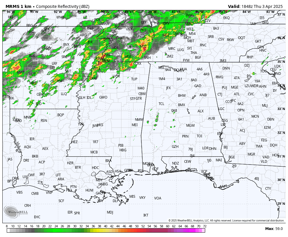
JUST LIKE SUMMER: We have a mix of sun and clouds across Alabama this afternoon with temperatures in the 85-90 degree range, right at record levels for early April. A few isolated showers have formed, but most of the state remains dry. To the north, a tornado watch is in effect for parts of North Mississippi and middle Tennessee, but the risk of severe storms will stay north and west of Alabama through tonight.
The strong upper ridge over Florida will remain in place, keeping most of Alabama dry and very warm tomorrow. Highs will be in the upper 80s for most locations.
THE ALABAMA WEEKEND: The ridge begins to break down. While a few isolated showers or storms are possible late Saturday afternoon, most of the rain will come late Saturday night into Sunday. SPC has most all of Alabama in a severe weather risk in their Day 3/4 outlooks.
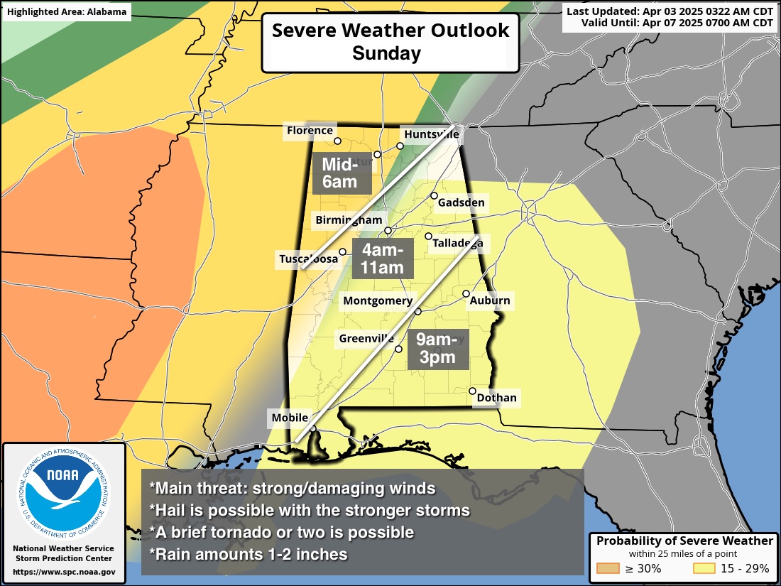
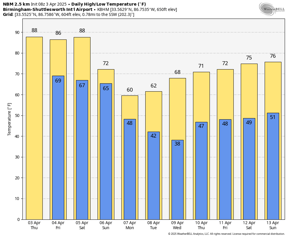
An organized batch of showers and storms will enter Northwest Alabama around midnight Saturday night… they will exit the southeast corner of the state Sunday afternoon. Storms that pass through Alabama will be capable of producing strong winds and hail; a brief tornado or two is possible. Rain amounts of 1-2 inches are expected. After a high in the upper 80s Saturday, Sunday’s high will be in the 70s thanks to clouds and rain.
NEXT WEEK: Much colder air rolls into Alabama Sunday night, and many communities over the northern half of the state will dip into the 30s early Tuesday and Wednesday morning. Colder spots could see a freeze. Then, clouds increase Wednesday, and we will mention a chance of showers Wednesday night into Thursday. See the video briefing for maps, graphics, and more details.
YESTERDAY/LAST NIGHT: Several violent tornadoes touched down across the Mid-South, including one at Bay and and Lake City, Arkansas, and Selmer, Tennessee. Over 200 tornado warnings were issued by various NWS offices from Arkansas to Indiana and Ohio.
ON THIS DATE IN 1974: Today is the 51st anniversary of the “Superoutbreak” of tornadoes the night of April 3, 1974. The event lasted into the early morning hours of April 4. In all, 148 tornadoes touched down across the eastern and southern U.S. Of them, 95 were rated F2 or stronger, and 40 were F4 or F5. A total of 335 people lost their life, and over 6,000 were injured that horrible night.
In Alabama, 86 were killed, and just under 1,000 were injured. The most violent tornado tore through Guin, in Marion County, where 23 lives were lost. Other communities hard hit included Jasper, Cullman, Tanner, Harvest, Hazel Green, and Huntsville.
Look for the next video briefing here by 6:00 a.m. tomorrow…
Category: Alabama's Weather, ALL POSTS, Weather Xtreme Videos
About the Author (Author Profile)
James Spann is one of the most recognized and trusted television meteorologists in the industry. He holds the AMS CCM designation and television seals from the AMS and NWA. He is a past winner of the Broadcast Meteorologist of the Year from both professional organizations.Subscribe
If you enjoyed this article, subscribe to receive more just like it.


