A Few Weekend Showers; Strong/Severe Storms Possible Late Sunday Night/Monday
SUNNY SPRING DAY: With a sunny sky temperatures are mostly in the mid to upper 70s across Alabama this afternoon. Tonight will be mostly fair with a low in the 50s and low 60s.
The weather stays dry tomorrow; most communities will reach the low 80s.
THE WEEKEND: We will mention a few passing showers along with a rumble of thunder Saturday and Sunday, but it looks more and more like a decent part of both days will be dry. New model output suggests the highest coverage of rain will be late Saturday night or Sunday morning. Highs both days will be somewhere between 75 and 82 degrees for most places.
SEVERE WEATHER THREAT: Unstable air will surge northward into the Deep South Sunday and Sunday night, and an energetic storm system will bring the chance of strong to severe thunderstorms late Sunday into Monday. Basically all of Alabama is defined in a severe weather risk by SPC.
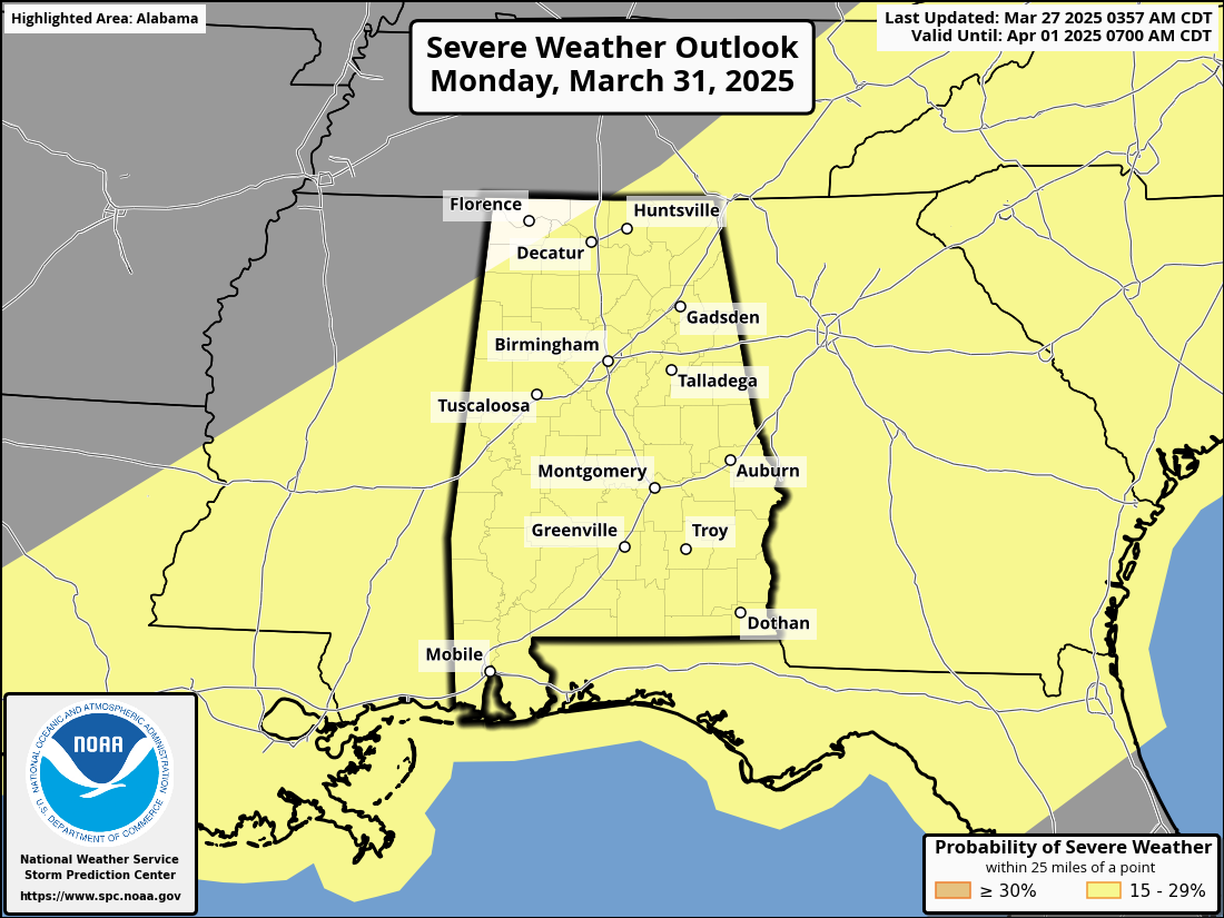
Considerable uncertainty remains with this event. While the large scale pattern certainly features a risk of severe thunderstorms with a robust warm sector in place, models differ with the small scale details which will really determine the magnitude of the threat. An organized batch of storms with potential for hail, strong winds, and isolated tornadoes will move through North Alabama early Monday morning, shifting into the southern counties by afternoon.
A higher tornado threat could form after midnight Sunday night and into the pre-dawn hours Monday over North Alabama if discrete cells can form ahead of the main line, but that potential is very “iffy” based on the latest model trends. Once we get within 60 hours of the event we will be in range of the high resolution convection allowing models, giving us a much clearer picture.
REST OF NEXT WEEK: Tuesday will be dry and mild with highs in the mid to upper 70s. Then, look for the warmest weather so far this year over the latter half of the week with highs in the low to mid 80s. New model data suggests a chance of rain Wednesday, followed by mostly dry weather Thursday and Friday See the video briefing for maps, graphics, and more details.
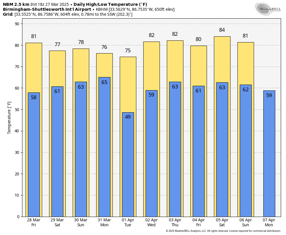
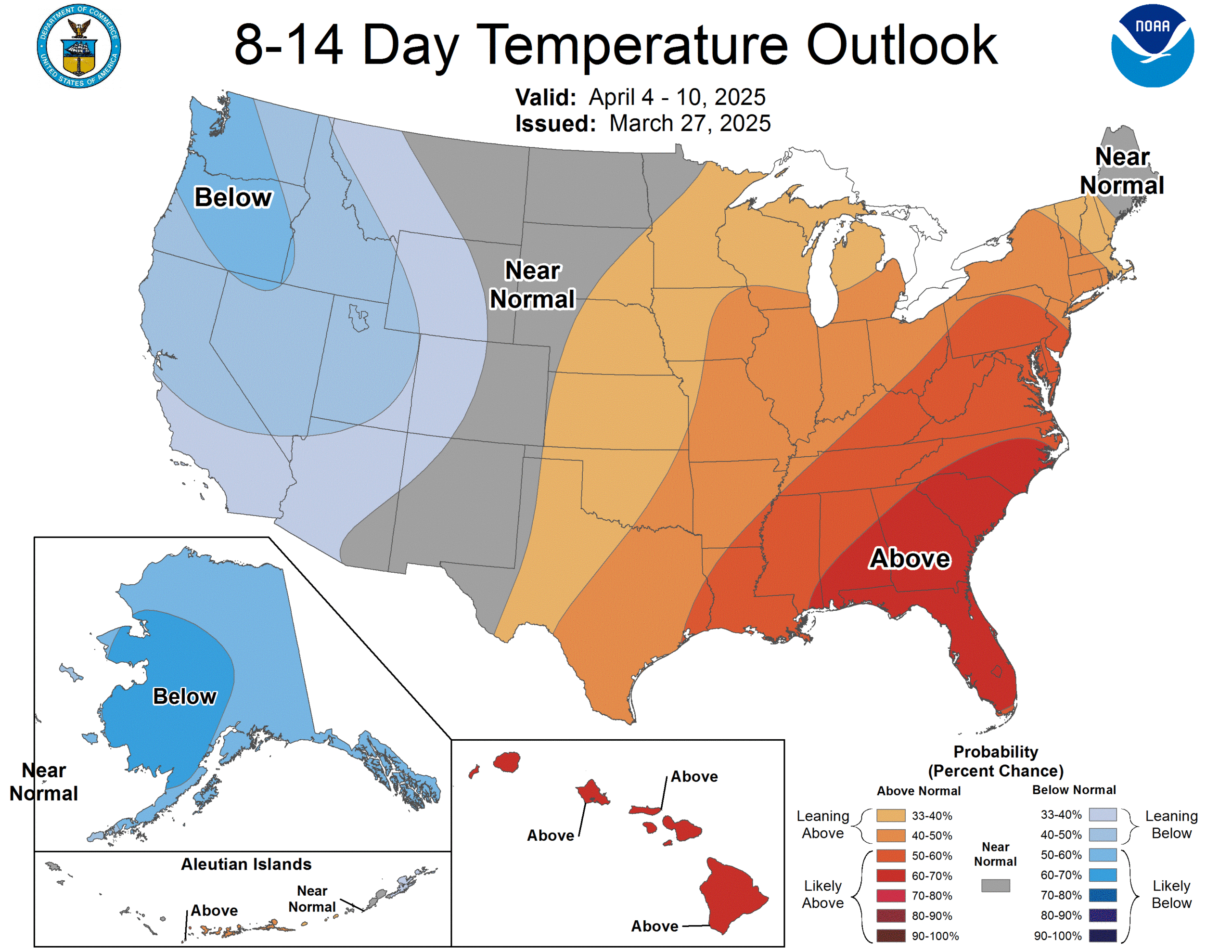
LONG RANGE: With an upper ridge over the region, temperatures will likely remain above average through April 10.
ON THIS DATE IN 1994: An EF-4 tornado struck the Goshen United Methodist Church, north of Piedmont in southern Cherokee County, killing 20 people during the morning worship service on Palm Sunday; 92 were injured. A warning was issued 12 minutes before the tornado destroyed the church building, but unfortunately they never heard it.
The deaths at the church brought to light the deficiencies in the NOAA Weather Radio network across the United States at the time, and the lack of NOAA Weather Radio use in many public spaces. We have come a long way since then, but we have much work to do. Every home, business, church, and public place must have a way of hearing warnings.
Later that day, an EF-2 tornado moved through North Shelby County… the tornado extensively damaged businesses and mobile homes and caused damage to Pelham High School. It dissipated just west of Meadowbrook as it moved down Alabama 119.
Look for the next video briefing here by 6:00 a.m. tomorrow…
Category: Alabama's Weather, ALL POSTS, Weather Xtreme Videos
About the Author (Author Profile)
James Spann is one of the most recognized and trusted television meteorologists in the industry. He holds the AMS CCM designation and television seals from the AMS and NWA. He is a past winner of the Broadcast Meteorologist of the Year from both professional organizations.Subscribe
If you enjoyed this article, subscribe to receive more just like it.


