Midday Nowcast: Oh So Nice!; Rain and Storms Return This Weekend
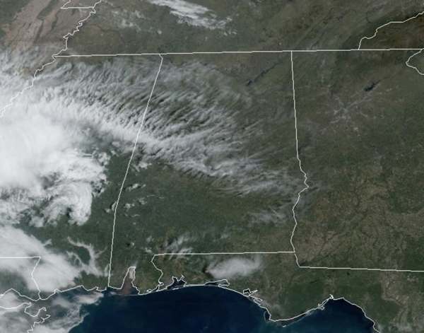
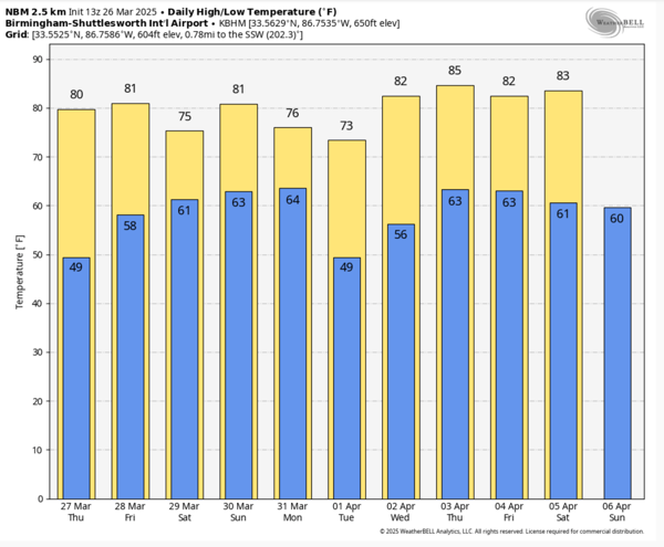
OH SO NICE!: We continue to enjoy mainly sunny days with highs in the mid and upper 70s, with some low 80s showing up on the maps. Nights are fair and refreshing with upper 40s and lower 50s. This weather will persist through Friday across Alabama. We do note, the satellite image shows some upper level clouds blowing into the state, but these will not have much of an impact and will give us generally a filtered sunshine look at times.
BIRMINGHAM ALMANAC: For March 26th, the average high for Birmingham is 70° and the average low is 47°. The record high is 86° set in 1929, while the record low is 22° set in 1955. We average 0.16” of precipitation on this date and the record value is 1.66” set in 1917.
STORMS RETURN THIS WEEKEND: Moisture begins to surge northward out of the Gulf of Mexico this weekend ahead of our next developing storm system. Scattered showers and storms are possible on Saturday, but we do not expect severe storms in Alabama on Saturday. Highs Saturday will be in the upper 70s.
Models are trending slower with the threat of strong and severe storms returning to Alabama this weekend, and for now, it looks like most of Sunday will be dry with only a few scattered showers possible. It will be warm and breezy, and temperature should climb into the lower 80s for much of the state.
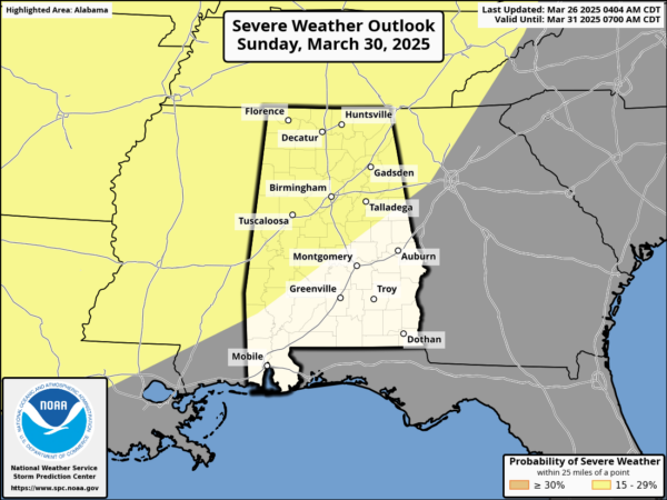
To our north and west Sunday, a dynamic storm system will cause severe weather in the Mississippi and Ohio River Valleys, the storms will then move into Alabama late Sunday night (mainly after midnight) into Monday. The SPC maintains the risk of severe storms for the entire state during this timeframe.
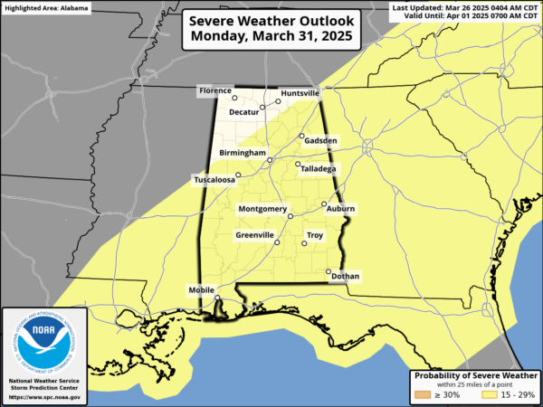
For now the timing for storms has the risk of severe storms for North Alabama arriving around midnight Sunday night through noon Monday. For the rest of the state, the threat window will be from 4AM-4PM Monday. The threats are typical of what you would expect with a spring-time severe weather event: large hail, damaging winds, and a few tornadoes. We will be much more specific about the magnitude of the event and the timing later this week.
NEXT WEEK: After Monday, Tuesday and Wednesday look dry, but more storms are in the forecast for the second half of the week. The weather will be very warm next week, likely the warmest temperature so far this year across Alabama with widespread mid-80s expected.
WORLD TEMPERATURE EXTREMES: Over the last 24 hours, the highest observation outside the U.S. was 109.4F at Mango, Togo. The lowest observation was -86.8F at Vostok, Antarctica.
CONTIGUOUS TEMPERATURE EXTREMES: Over the last 24 hours, the highest observation was 102F at Ogilby, CA. The lowest observation was -8F at Big Bay, MI.
Category: Alabama's Weather, ALL POSTS, Social Media
About the Author (Author Profile)
Macon, Georgia Television Chief Meteorologist, Birmingham native, and long time Contributor on AlabamaWX. Stormchaser. I did not choose Weather, it chose Me. College Football Fanatic. @Ryan_StinnetSubscribe
If you enjoyed this article, subscribe to receive more just like it.


