Midday Nowcast: Gradual Clearing Today; Great Weather All Week Before Storms Return This Weekend
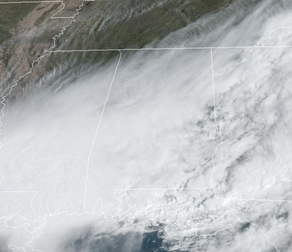
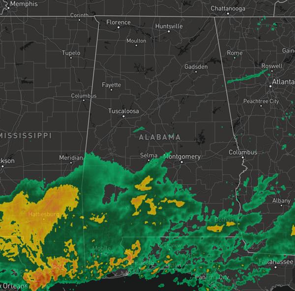
RAIN EXITING: Most of the rain has ended across the northern half of Alabama, and through the afternoon hours, the sky will clear from northwest to southeast. Areas of rain continue across South Alabama, but this will come to an through the evening hours.
Highs this afternoon are generally in the lower 70s. Tonight, expect a clear and chilly night with mid and upper 40s across much of Alabama.
BIRMINGHAM ALMANAC: For March 24th, the average high for Birmingham is 69° and the average low is 47°. The record high is 89° set in 1929, while the record low is 23° set in 1968. We average 0.18” of precipitation on this date and the record value is 1.91” set in 1957.
ACROSS THE USA: Across the Pacific Northwest, a plume of Pacific moisture will continue to bring moderate to locally heavy rainfall to lower elevations and heavy snow to the northern Cascades into the northern Rockies through Monday. Warm spring-like temperatures will expand over the western and central U.S. this week. Record tying or breaking highs will be possible from Texas west into the Desert Southwest.
GREAT WEATHER REST OF WEEK: Splendid spring weather all week across Alabama with generally sunny days with highs in the mid and upper 70s, some low 80s expected in some spots. Nights will be fair and cool with upper 40s and lower 50s. This is one of those weeks I’ll have my windows and doors open, letting the house air out. No AC or heat will be needed…just hope the house doesn’t get covered in pollen. This morning’s rain wiped it out temporarily, but it will return with vengeance in the coming days and weeks.
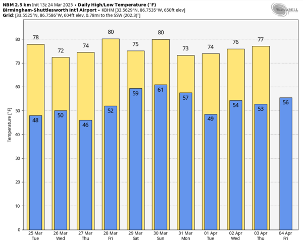
STORMS RETURN THIS WEEKEND: Warm, moist air begins to surge northward this weekend, and we will see more clouds and some scattered showers on Saturday. These will be scattered in nature, and shouldn’t cause too many impacts. Highs Saturday will be in the upper 70s.
On Sunday, a very dynamic storm system will bring the potential for severe thunderstorms to much of the Deep South. The Storm Prediction Center (SPC) has defined a large severe weather risk from the Gulf Coast to the southern Great Lakes and this risk includes almost all of Alabama.

For now, the highest severe weather risk will come late Sunday and Sunday night, but it is simply too early for details concerning the threats, timing, and magnitude of the event. We will be able to be more specific later this week. For now, let us in the weather department worry about it, and my advice is to enjoy this incredible spring weather most of this week .
WORLD TEMPERATURE EXTREMES: Over the last 24 hours, the highest observation outside the U.S. was 109.8F at Matam, Senegal. The lowest observation was -88.8F at Dome C, Antarctica.
CONTIGUOUS TEMPERATURE EXTREMES: Over the last 24 hours, the highest observation was 97F at Faith Ranch, TX. The lowest observation was -2F at Estcourt Station, ME.
Category: Alabama's Weather, ALL POSTS, Social Media
About the Author (Author Profile)
Macon, Georgia Television Chief Meteorologist, Birmingham native, and long time Contributor on AlabamaWX. Stormchaser. I did not choose Weather, it chose Me. College Football Fanatic. @Ryan_StinnetSubscribe
If you enjoyed this article, subscribe to receive more just like it.


