Two New Severe Thunderstorm Warnings Just Issued
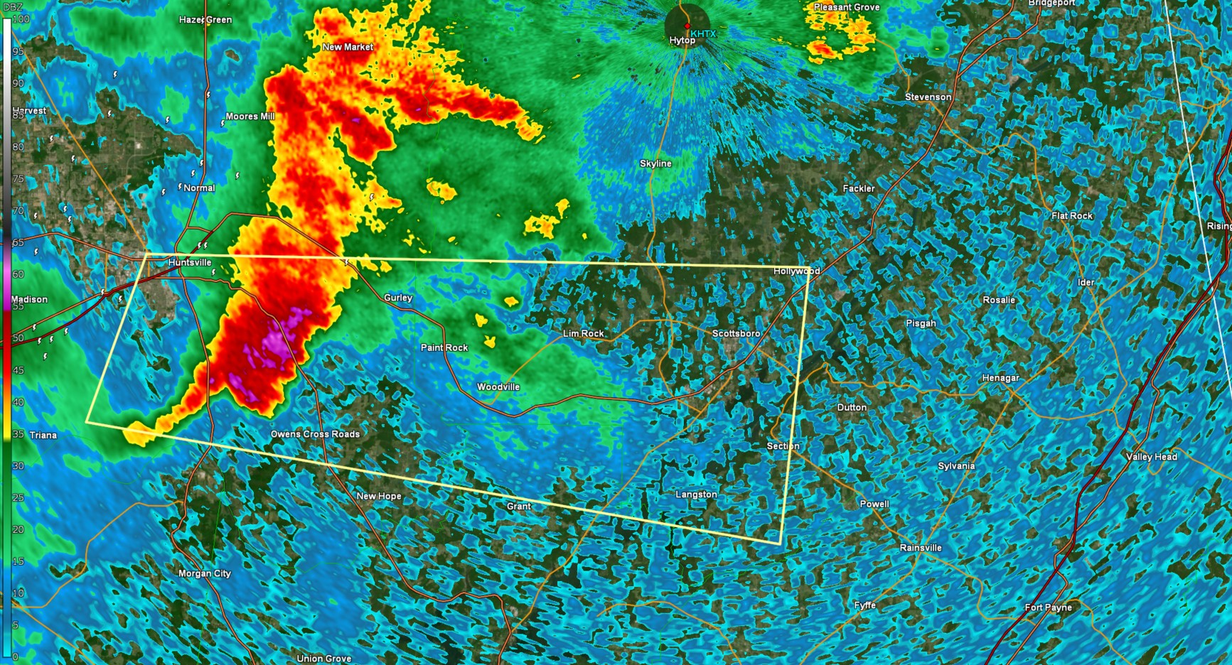
 The National Weather Service in Huntsville Alabama has issued a
* Severe Thunderstorm Warning for...
Northeastern Marshall County in northeastern Alabama...
Southwestern Jackson County in northeastern Alabama...
Southern Madison County in north central Alabama...
* Until 930 PM CDT.
* At 851 PM CDT, a severe thunderstorm was located near Huntsville,
moving east at 45 mph.
HAZARD...60 mph wind gusts and nickel size hail.
SOURCE...Radar indicated.
IMPACT...Expect damage to roofs, siding, and trees.
* Locations impacted include...
Paint Rock, Huntsville, Langston, Lim Rock, Woodville, Hampton
Cove, Redstone Arsenal, Section, Scottsboro, and Hollywood.
PRECAUTIONARY/PREPAREDNESS ACTIONS...
For your protection move to an interior room on the lowest floor of a
building.
The National Weather Service in Huntsville Alabama has issued a

* Severe Thunderstorm Warning for...
  Northeastern Marshall County in northeastern Alabama...
  Southwestern Jackson County in northeastern Alabama...
  Southern Madison County in north central Alabama...

* Until 930 PM CDT.

* At 851 PM CDT, a severe thunderstorm was located near Huntsville,
  moving east at 45 mph.

  HAZARD...60 mph wind gusts and nickel size hail.

  SOURCE...Radar indicated.

  IMPACT...Expect damage to roofs, siding, and trees.

* Locations impacted include...
  Paint Rock, Huntsville, Langston, Lim Rock, Woodville, Hampton
  Cove, Redstone Arsenal, Section, Scottsboro, and Hollywood.

PRECAUTIONARY/PREPAREDNESS ACTIONS...

For your protection move to an interior room on the lowest floor of a
building.
In Addition, a severe warning is in effect for parts of Fayette and Marion counties as well:
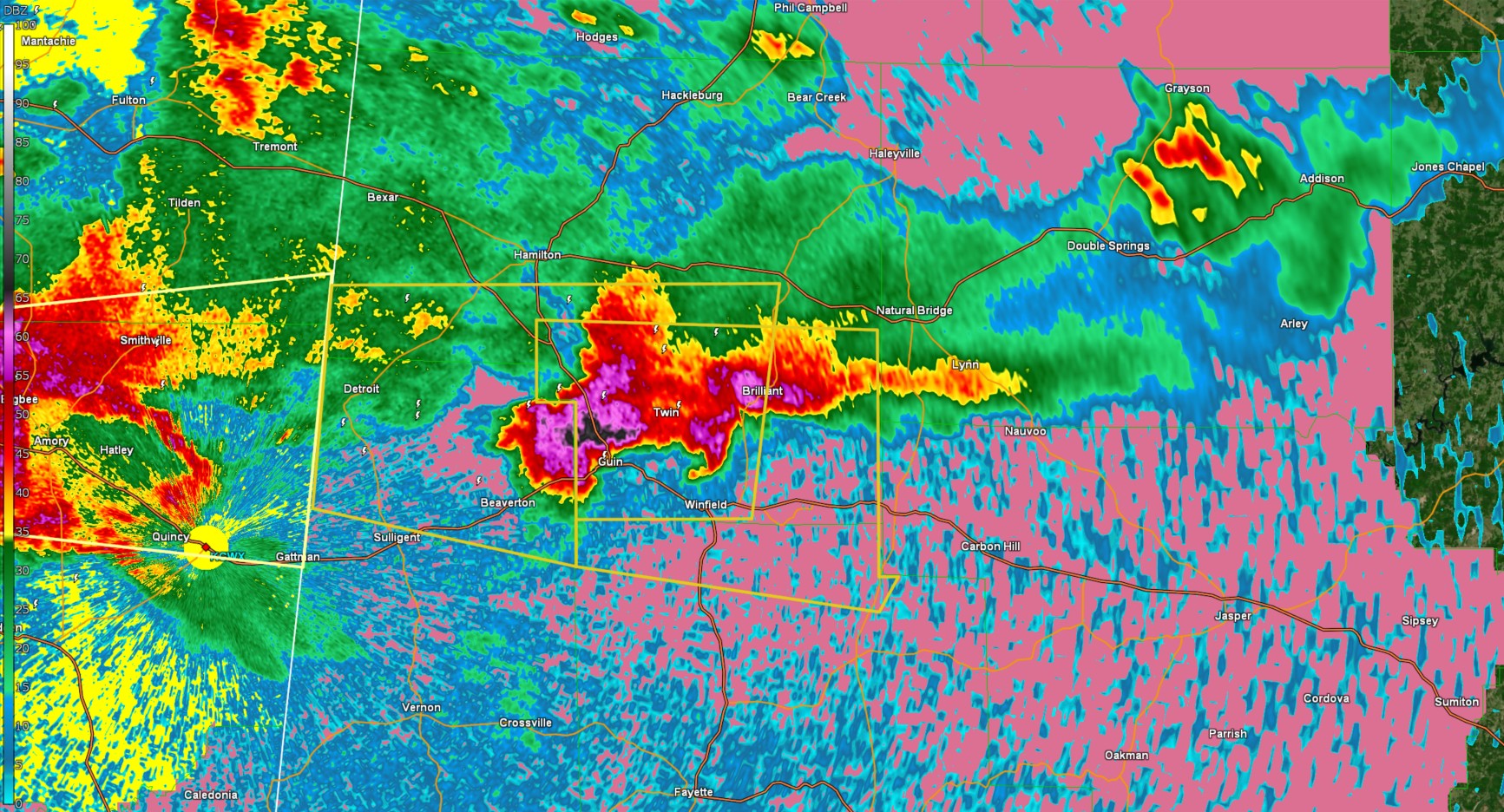
The National Weather Service in Birmingham has issued a

* Severe Thunderstorm Warning for...
  Southeastern Marion County in northwestern Alabama...
  Northwestern Fayette County in west central Alabama...

* Until 945 PM CDT.

* At 851 PM CDT, a severe thunderstorm was located over Guin, or 9
  miles northwest of Winfield, moving east at 25 mph.

  HAZARD...Two inch hail and 60 mph wind gusts.

  SOURCE...Radar indicated.

  IMPACT...People and animals outdoors will be injured. Expect hail
           damage to roofs, siding, windows, and vehicles. Expect
           wind damage to roofs, siding, and trees.

* Locations impacted include...
  Brilliant, Tucker, Guin, Gu-
  Win, Bazemore, Wayside, Texas, Winfield, Marion County Public Lake,
  Glen Allen, Pikeville, and Twin.

PRECAUTIONARY/PREPAREDNESS ACTIONS...

For your protection move to an interior room on the lowest floor of a
building.
Category: Alabama's Weather, ALL POSTS, Social Media
About the Author (Author Profile)
Jack is a junior at Mississippi State University studying meteorology. He has several years of forecasting experience through a local group of forecasters in Maryland where he resides. Jack plans to become a broadcast meteorologist after graduation.Subscribe
If you enjoyed this article, subscribe to receive more just like it.


