Severe Weather Threat Tonight; Wind Advisory Issued for the Tennessee Valley
An active springtime setup is unfolding across the Deep South today, with a potent upper-level disturbance diving southeast through the Midwest, helping to deepen surface low pressure over the Great Lakes region. A trailing cold front extends southwest from this low through the Mid-Mississippi Valley and into north-central Texas. As this front advances eastward and encounters a warm, moist, and increasingly unstable airmass, it will serve as the focus for scattered strong to severe thunderstorm development later this afternoon and evening.
Strong Dynamics Aloft and Low-Level Shear in Place
At the mid-levels, a strong jet streak exceeding 90 knots is punching into Illinois, creating broad-scale ascent over the Tennessee Valley. Meanwhile, strengthening low-level southwesterly flow continues to pull 60+ degree dewpoints northward into Mississippi, western Tennessee, and eventually into Alabama. Model soundings indicate mid-level lapse rates in the 7.0–7.5°C/km range, supportive of large hail development, and 0–6 km shear values in the 45–55 kt range—sufficient for organized multicells and rotating storms. However, veered low-level flow and limited low-level CAPE reduce the tornado threat somewhat, especially east of I-65.
Threats: Wind, Hail, and an Isolated Tornado
The greatest threats will be isolated damaging wind gusts (up to 60 mph) and hail up to quarter size or larger, particularly across northwest Alabama where the environment is most favorable. The tornado risk is low but non-zero, especially where any discrete or semi-discrete storm structures can interact with modest low-level helicity in western Alabama during the early evening. Any tornadoes that do occur are expected to be short-lived and relatively isolated.
Wind Advisory Issued for Tennessee Valley
The NWS in Huntsville has issued a wind advisory for its counties in Alabama and southern Tennessee with sustained winds 15-25 mph and gusts to 40 mph. Secure loose objects and watch for strong cross winds when driving, particularly in high profile vehicles. Gusts across Central Alabama could reach 30 to 35 mph at times.
Expanded Slight Risk and Updated Timing
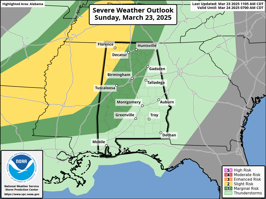
The Storm Prediction Center has expanded the Level 2 Slight Risk eastward into parts of Alabama, now including areas like Elkmont, Moulton, Fayette, and Pickensville. The Level 1 Marginal Risk reaches as far east as Fort Payne, Gadsden, Pell City, Clanton, and down through Monroe and Washington Counties in southern Alabama. Storms will begin impacting northwest Alabama after 6 PM, with the main severe window stretching from 8 PM to 2 AM. Here’s the estimated timing by region:
- 7-8 PM: Shoals, Moulton
- 8-10 PM: Huntsville, Cullman
- 9–10 PM: Hamilton, Lamar, Fayette, Walker Counties
- 11 PM–Midnight: Tuscaloosa, Birmingham, Gadsden
- Midnight–1 AM: Anniston, Clanton, Selma
- 1–2:30 AM: Montgomery, Auburn, Greenville, Alex City
By the time storms reach the I-85/I-65 corridor, they should be weakening below severe thresholds.
Impacts: Power Outages and Wind Damage Possible
Outside of thunderstorm activity, non-thunderstorm wind gusts of 20–30 mph are already occurring, with localized gusts up to 35 mph possible in higher terrain. These gusts could down tree limbs or power lines and create sporadic power outages even before storms arrive. Combined with the expected thunderstorm winds later tonight, the risk of scattered damage increases.
Safety and Preparedness Tips
- Charge devices and prepare for possible brief power interruptions.
- Review your severe weather safety plan before storms arrive.
- Make sure you have at least two reliable ways to receive warnings—especially one that will wake you up if you’re sleeping when storms move through.
- Know your safe place and be ready to move there quickly if a warning is issued.
Bottom Line
Confidence has increased that northwest and north-central Alabama will experience at least isolated severe weather this evening, especially west of I-65. While this is not a widespread or high-end outbreak, storms could still bring damaging wind gusts and large hail. A tornado or two cannot be ruled out. The situation should remain below severe levels by the time storms reach the I-85 corridor after 2 AM.
Stay alert, and stay weather aware. Jack Rudden will be covering until 11 pm, Scott Brown will have a midnight update, and I will be with you through the overnight.
Category: Alabama's Weather, ALL POSTS, Severe Weather, Social Media
About the Author (Author Profile)
Bill Murray is the President of The Weather Factory. He is the site's official weather historian and a weekend forecaster. He also anchors the site's severe weather coverage. Bill Murray is the proud holder of National Weather Association Digital Seal #0001 @wxhistorianSubscribe
If you enjoyed this article, subscribe to receive more just like it.


