Comprehensive List Of All 16 Alabama Tornadoes From March 15th Tornado Outbreak
The NWS office in Birmingham and Huntsville has worked countless hours over the last 5 days to survey the paths of all 16 tornadoes across the state from last weekends tornado outbreak and we want to give them a huge thank you for their quick work in getting these surveys completed as fast as they did! Just one more reason why they are 2 of the best NWS offices in the nation!
Below is a list of all the tornadoes that were confirmed, information from the NWS damage surveys, as well as a graphic for each from the NWS Damage Assessment Toolkit.
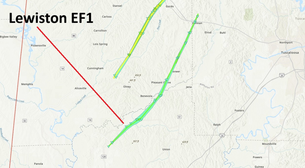
.Lewiston-Holman Tornado...

Rating:                 EF1
Estimated Peak Wind:    90 mph
Path Length /statute/:  26.26 miles
Path Width /maximum/:   1200 yards
Fatalities:             0
Injuries:               0

Start Date:             03/15/2025
Start Time:             03:08 PM CDT
Start Location:         2 SSE Pleasant Ridge / Greene County / AL
Start Lat/Lon:          32.9909 / -88.0707

End Date:               03/15/2025
End Time:               03:43 PM CDT
End Location:           3 NW Elrod / Tuscaloosa County / AL
End Lat/Lon:            33.3007 / -87.821

Survey Summary:
National Weather Service meteorologists surveyed damage
associated with a tornado in Greene, Pickens, and Tuscaloosa
Counties that began around 3:08 PM on March 15, 2025. The tornado
began on the south side of Highway 14 in Greene County, then
moved northeastward and crossed County Road 161 near Lewiston.
The tornado intensified as it approached County Road 60 where it
reached its maximum intensity of 90 miles per hour briefly.
Several trees were snapped with a few falling into an older
mobile home. The tornado then paralleled County Road
183 northeastward where several trees were seen uprooted or
snapped along or just east of the county road. The tornado
weakened as it crossed County Road 156 and the Pickens County
Line. It continued north-northeastward and re-intensified in a
wooded area east of Benvola Road. Numerous snapped trees were
observed along an unnamed dirt road. More trees were uprooted or
snapped along Lum Fife Road before the tornado eventually crossed
Highway 82 near Holman. Several trees were downed along Highway
82 near Minas Road before the tornado weakened on the north side
of Highway 82 in Tuscaloosa County and lifted along and just west
of Lee Bonner Road where a few more trees were uprooted.
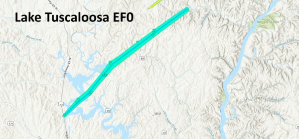
.Lake Tuscaloosa Tornado...

Rating:                 EF0
Estimated Peak Wind:    80 mph
Path Length /statute/:  11.54 miles
Path Width /maximum/:   400 yards
Fatalities:             0
Injuries:               0

Start Date:             03/15/2025
Start Time:             04:00 PM CDT
Start Location:         1 SSW Lake Tuscaloosa Tierce Pattton Bridge / Tuscaloosa County / AL
Start Lat/Lon:          33.3475 / -87.6089

End Date:               03/15/2025
End Time:               04:14 PM CDT
End Location:           3 SE Windham Springs / Tuscaloosa County / AL
End Lat/Lon:            33.4562 / -87.4586

Survey Summary:
National Weather Service meteorologists surveyed damage
associated with a tornado in Tuscaloosa County that began around
4:00 PM on March 15, 2025. The tornado began along Hwy 43 near
Smith Landing Road where a metal building lost part of its roof.
The tornado then crossed portions of Lake Tuscaloosa and moved
through a residential area along Tierce Patton Rd where several
trees were snapped or uprooted. The tornado then continued
northeastward, bringing down several trees on Turquoise Lane. The
tornado weakened and lifted in a wooded area east of Highway
69 and north of Ben Clements Road around 4:14 PM. The maximum
wind was estimated to be 80 MPH based on tree damage.

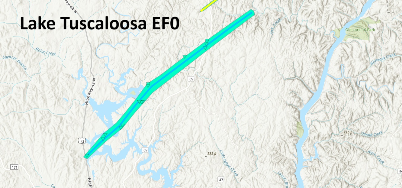
.Windham Springs/Sipsey Tornado...

Rating:                 EF2
Estimated Peak Wind:    120 mph
Path Length /statute/:  39.48 miles
Path Width /maximum/:   0 yards
Fatalities:             0
Injuries:               0

Start Date:             03/15/2025
Start Time:             04:12 PM CDT
Start Location:         2 S Windham Springs / Tuscaloosa County / AL
Start Lat/Lon:          33.4571 / -87.5051

End Date:               03/15/2025
End Time:               04:55 PM CDT
End Location:           3 NNW Empire / Walker County / AL
End Lat/Lon:            33.8554 / -87.0311

Survey Summary:
The tornado first touched down just east of CR 69 in the Windham
Springs community. Here a few softwood trees sustained damage.
The tornado tracked northeast crossing Goodwater Road. Here large
tree branches were broken, a few trees were uprooted and a small
farm building sustained damage. Minor and sporadic tree damage
continued across far northeast Tuscaloosa county with uprooted
trees along Blackburn Road. The tornado crossed into Walker
county with notable damage in the CR 6 / Tutwiler Road area. Here
large trees were uprooted and/or snapped. Several homes sustained
roof damage and at least one home had some windows blown out.
Additional damage occurred along Bruner HIll Road and Bruner
Lane. The tornado then tracked through the Pleasant Field and
Brandleytown communities with mainly tree damage. A few power
lines were also noted down in these areas.  The tornado crossed I-
22 with a few trees down along CR 22 on the south side of
Cordova. The tornado damage became more pronounced and consistent
as it tracked toward the Argo community. Widespread tree damage
was noted along Highway 78 with many trees snapped or uprooted.
Minor structural damage occurred to a couple of homes along
Mathes Creek Road. The residents of these homes mentioned getting
the warning and sheltering before the tornado hit. The tornado
began to widen as it crossed the Mulberry Fork and moved into
Sipsey. Widespread tree damage was noted in Sipsey with many
trees snapped. Multiple structures in downtown Sipsey also
sustained damage. Several homes sustained roof damage with a few
having their windows blown out. An anchored mobile home was
overturned and destroyed. The tornado was likely at its widest
here with a width of approximately 1,000 yards. The tornado then
tracked northeast along Campbellville into the Campbellville
community. Large swaths of softwood trees were snapped or
uprooted in this area. In addition, several conventional homes
sustained notable structural damage. At least 3 homes had
significant roof and siding damage with uplift and partial roof
loss. One two story home here lost a significant portion of the
roof, second floor, and back of the home. The family here
reported getting the warning and sheltering in their downstairs
basement with the pets. A significant number of softwood and
hardwood trees were also snapped in this area. Due to this, the
maximum rating of EF-2 /120 mph was estimated in this location.
Further north, the tornado began to narrow and slowly wind down
with sporadic tree damage noted along Campbellville Road. It
appears the tornado lifted just south of the Cullman county line
along Mandy Williams Road.
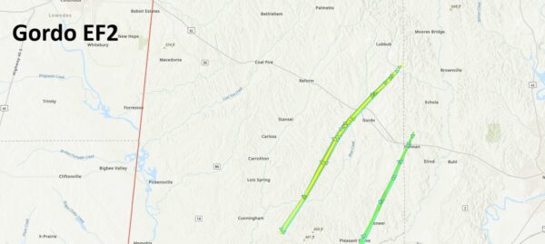
.Gordo Tornado...

Rating:                 EF2
Estimated Peak Wind:    115 mph
Path Length /statute/:  21.53 miles
Path Width /maximum/:   950 yards
Fatalities:             0
Injuries:               0

Start Date:             03/15/2025
Start Time:             04:32 PM CDT
Start Location:         1 W Johnston Lake / Pickens County / AL
Start Lat/Lon:          33.1499 / -88.0569

End Date:               03/15/2025
End Time:               04:58 PM CDT
End Location:           3 SE Lubbub / Pickens County / AL
End Lat/Lon:            33.4013 / -87.8401

Survey Summary:
National Weather Service meteorologists surveyed damage
associated with a tornado in Pickens County  that began around
4:32 PM on March 15, 2025. The tornado began in a wooded area
north of County Road 2, then moved northeastward across Houston
Windle Road near New Salem Missionary Baptist Church. The tornado
began to intensify as it moved northeastward, reaching EF-
1 strength as it crossed Ray Bass Road where numerous snapped
trees were observed.  The tornado continued to intensify,
reaching EF-2 strength with maximum winds around 115 miles per
hour as it crossed Ebenezer Church Road. It likely maintained
this strength as it continued northeastward, crossing Hwy
86 where widespread tree damage was noted. As the tornado moved
into the Bostic Community, it destroyed several chicken houses on
Russell Farm Road. One residence on Russell Farm Road sustained
significant roof damage, and one manufactured home to the north
of Russell Farm Road was lifted and displaced. Auger anchoring
systems were pulled from the ground, and the home was severely
damaged, but the frame was largely intact.  The tornado then
crossed Highway 82 on the west side of Gordo. A home sustained
substantial damage to the roof along Highway 159 near the
intersection of County Road 88. There were also numerous uprooted
and snapped trees observed around these locations. The then
tracked on the north side of County Road 88, destroying several
more chicken houses before weakening as it reached Fair Road
where another home sustained partial roof damage. The tornado
eventually lifted on the north side of Zion Road.
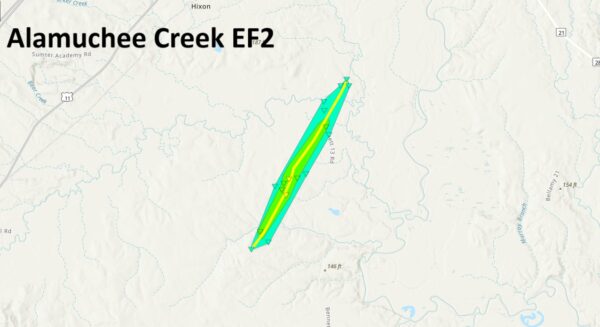
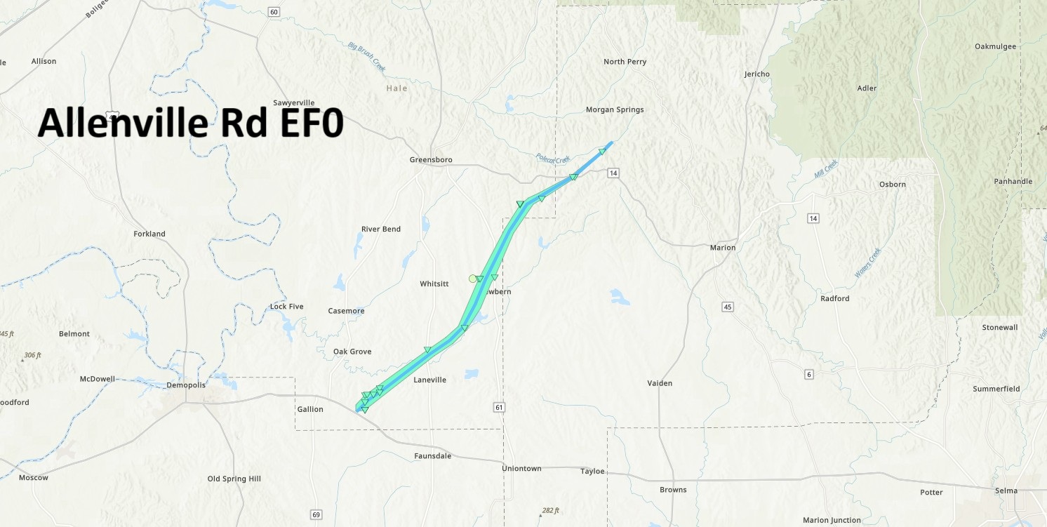
.Alamuchee Creek Tornado... Rating: EF2 Estimated Peak Wind: 120 mph Path Length /statute/: 3.32 miles Path Width /maximum/: 650 yards Fatalities: 0 Injuries: 0 Start Date: 03/15/2025 Start Time: 05:20 PM CDT Start Location: 4 E Old Mallard Airport / Sumter County / AL Start Lat/Lon: 32.4847 / -88.2078 End Date: 03/15/2025 End Time: 05:26 PM CDT End Location: 4 NW Lilita / Sumter County / AL End Lat/Lon: 32.5264 / -88.1798 Survey Summary: The tornado began in a densely wooded area east of Loon Curl Rd within a private hunting camp. It tracked northeast towards County rd 13, crossing through and destroying several pine groves along its path. In the area of most intense damage, a pine grove featured hundreds of snapped trees in a width of roughly 500 yards. The EF2 rating was determined strictly from this area of concentrated tree damage. The tornado began to weaken as it crossed County road 13 just south of Alamuchee Creek where multiple softwood trees were uprooted and a few were snapped. It continued northeast where it then crossed a dirt road just east of county road 13 where it produced sporadic tree damage. The tornado dissipated shortly thereafter..Allenville Road Tornado... Rating: EF0 Estimated Peak Wind: 80 mph Path Length /statute/: 21.75 miles Path Width /maximum/: 1300 yards Fatalities: 0 Injuries: 0 Start Date: 03/15/2025 Start Time: 06:38 PM CDT Start Location: 3 E Gallion / Hale County / AL Start Lat/Lon: 32.4962 / -87.6689 End Date: 03/15/2025 End Time: 07:05 PM CDT End Location: 2 S Morgan Springs / Perry County / AL End Lat/Lon: 32.7189 / -87.4183 Survey Summary: The tornado touched down just north of US Hwy 80 west of Allenville Road, producing minor tree damage to numerous cedar trees. The broad, weak but discernible tornado moved northeastward crossing Allenville Road, CR 12, and AL Hwy 25 continuing to cause scattered tree damage. The tornado crossed AL Hwy 61 north of Newbern, and began to turn more to the east. It continued into Perry County, and as it crossed AL Hwy 14 it produced the most significant tree damage of its path, with numerous trees uprooted across the road. The last tree damage of this tornado occurred on Morgan Springs Road, before it moved off to the northeast and dissipated somewhere over Polecat Creek before reaching Walter Boyles Road.
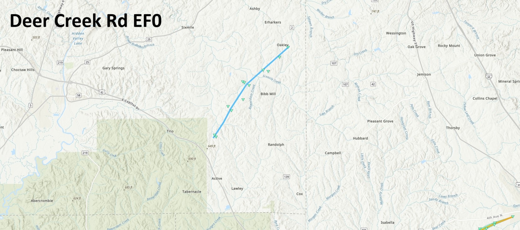
.Deer Creek Road Tornado...

Rating:                 EF0
Estimated Peak Wind:    80 mph
Path Length /statute/:  7.63 miles
Path Width /maximum/:   75 yards
Fatalities:             0
Injuries:               0

Start Date:             03/15/2025
Start Time:             07:39 PM CDT
Start Location:         2 NNE Talladega National Forest / Bibb County / AL
Start Lat/Lon:          32.9063 / -86.9776

End Date:               03/15/2025
End Time:               07:54 PM CDT
End Location:           2 SE Ashby / Bibb County / AL
End Lat/Lon:            32.9906 / -86.8946

Survey Summary:
National Weather Service meteorologists surveyed damage
associated with a tornado in Eastern Bibb County  around 7:39 PM
on March 15, 2025. The tornado began on the north side of Highway
82 near the Maud Community. Trees were snapped along Deer Creek
Road before continuing northeastward and crossed Antioch Road,
County Road 171, and Highway 139. The tornado lifted East of Hwy
139 near the Oakley Community at around 7:54 PM. Maximum winds
were estimated to be around 80 miles per hour.
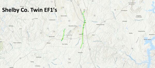
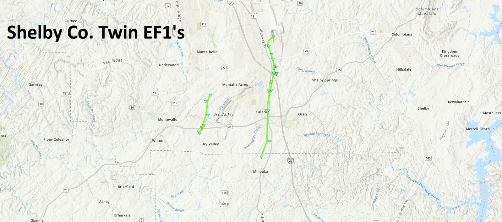
.Calera Tornado...

Rating:                 EF1
Estimated Peak Wind:    90 mph
Path Length /statute/:  7.28 miles
Path Width /maximum/:   250 yards
Fatalities:             0
Injuries:               0

Start Date:             03/15/2025
Start Time:             07:57 PM CDT
Start Location:         1 N Minooka Park / Chilton County / AL
Start Lat/Lon:          33.066 / -86.7608

End Date:               03/15/2025
End Time:               08:11 PM CDT
End Location:           2 ESE Shelby County Airport / Shelby County / AL
End Lat/Lon:            33.169 / -86.7535

Survey Summary:
The tornado began near the Chilton/Shelby County line in South
Calera and moved northward into downtown Calera, where mostly
tree damage was noted. There were several mobile homes damaged on
13th Street as the tornado paralleled Highway 31 before crossing
Interstate 65, where several campers at a dealership were rolled
and/or tossed. Numerous snapped trees were noted at this location
as well. The tornado made a left turn over Limestone Parkway and
moved north-northwest over a shopping center just east of the
intersection of US-31 and AL-70. Thereafter, the tornado moved
into the  cone of silence  of the KBMX RADAR near the O Neal
Quarry office, where many trees were snapped and uprooted. After
speaking with Lhoist quarry officials, no damage was reported at
the quarry, and the end of the tornado was placed just to the
north of Oak Tree Ln, where a few trees were downed. Maximum
winds were estimated to be around 90 miles per hour at both the
mobile home neighborhood and the camper dealership.

.Lawler Drive Tornado...

Rating:                 EF1
Estimated Peak Wind:    90 mph
Path Length /statute/:  2.55 miles
Path Width /maximum/:   150 yards
Fatalities:             0
Injuries:               0

Start Date:             03/15/2025
Start Time:             08:00 PM CDT
Start Location:         2 ESE Montevallo / Shelby County / AL
Start Lat/Lon:          33.0875 / -86.8291

End Date:               03/15/2025
End Time:               08:07 PM CDT
End Location:           1 SE American Village / Shelby County / AL
End Lat/Lon:            33.1225 / -86.817

Survey Summary:
National Weather Service meteorologists surveyed damage
associated with a tornado in Southern Shelby County around
8:00 PM on March 15, 2025. The tornado began near Highway 19 and
quickly intensified as it crossed Highway 25, reaching a maximum
intensity of 90 miles per hour as it crossed Lawler Drive. The
tornado continued northward eventually ending along Spring Creek
Road around 8:07 PM.

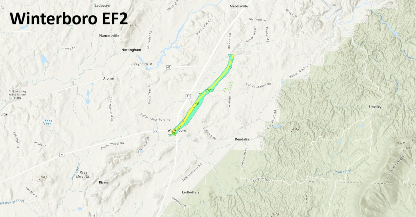
.Winterboro EF-2 Tornado...

Rating:                 EF2
Estimated Peak Wind:    120 mph
Path Length /statute/:  3.63 miles
Path Width /maximum/:   500 yards
Fatalities:             1
Injuries:               1

Start Date:             03/15/2025
Start Time:             08:42 PM CDT
Start Location:         Winterboro / Talladega County / AL
Start Lat/Lon:          33.3194 / -86.2005

End Date:               03/15/2025
End Time:               08:49 PM CDT
End Location:           3 NNE Winterboro / Talladega County / AL
End Lat/Lon:            33.3603 / -86.1623

Survey Summary:
National Weather Service Meteorologists surveyed damage in the
town of Winterboro and just to the northeast and determined that
the damage was consistent with a tornado.  The tornado touched
down just to the southwest of Winterboro High School, damaging
the football press box and surrounding baseball and softball
fields.  The tornado quickly intensified as it reached the Old
Winterboro High School building, lifting a school bus onto the
side of the gymnasium. The gymnasium sustained significant
damage, with walls mostly collapsed on more than one side.  Winds
were estimated to be around 120mph at this location, where wooden
power poles were also snapped.  Debris from the collapsed
gymnasium was blown across State Highway 76 and the old school
building also sustained roof damage. The tornado continued to the
northeast, where numerous trees were snapped and uprooted and
homes sustained damage due to falling trees at the intersection
of Highway 76 and 21.  As the tornado moved parallel to Bob White
Road, it maintained EF-2 intensity along the roadway and
destroyed a single-wide manufactured home.  The debris from the
home was blown westward across Bob White Road.  One fatality
occurred at this location.  Outside of the peak intensity of the
tornado, some homes and farm outbuildings sustained roof damage
on the far eastern edge of the path on Bob White Road.  The
tornado continued northeastward, weakening as it crossed Bullocks
Ferry Rd and finally lifting just to the northeast of Whiting Rd
and Lawler Cir.  The tornado totaled 3.63 miles and had an
estimated width of 500 yards.
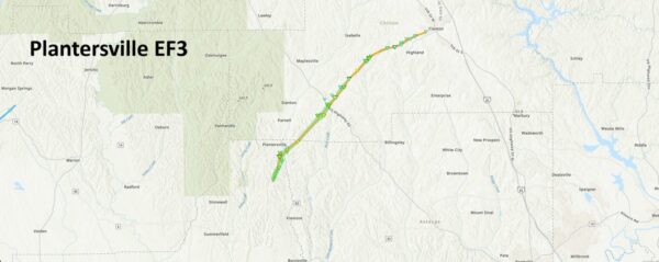
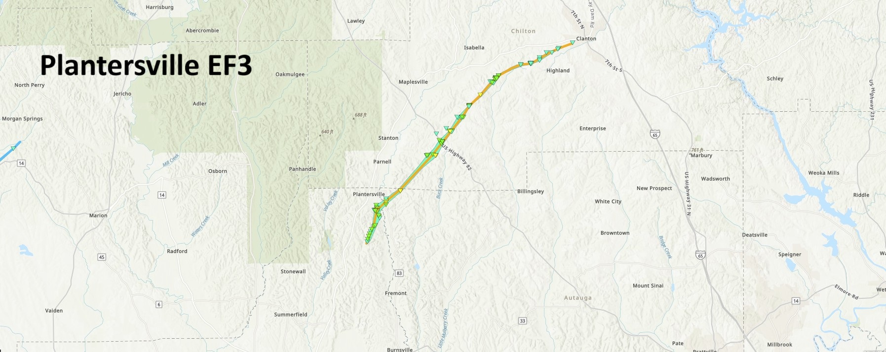
.Plantersville Tornado...

Rating:                 EF3
Estimated Peak Wind:    140 mph
Path Length /statute/:  24.33 miles
Path Width /maximum/:   1000 yards
Fatalities:             2
Injuries:               2

Start Date:             03/15/2025
Start Time:             08:50 PM CDT
Start Location:         1 NNW Valley Creek Junction / Dallas County / AL
Start Lat/Lon:          32.5978 / -86.9374

End Date:               03/15/2025
End Time:               09:20 PM CDT
End Location:           1 WSW Clanton / Chilton County / AL
End Lat/Lon:            32.8339 / -86.6501

Survey Summary:
The tornado formed and intensified quickly about 2 mile south of
Plantersville along County Road 63, uprooting swaths of trees
right from the start.  The tornado travelled northward into
Plantersville and intensified to its maximum intensity of a
140 MPH EF3 tornado in the south end of town, where trees across
the entire area were uprooted, snapped, and even debarked.
Several homes and businesses were destroyed, which unfortunately
resulted in 2 fatalities and 2 injuries.  The tornado began a
more northeasterly trajectory as it left Plantersville, but still
remained strong as it crossed into Autauga County.  Entire swaths
of hardwood trees were uprooted and snapped, and estimates were
given the maximum rating possible for tree fall/tree snap at
134 MPH.  Had there been other damage indicators impacted, it is
quite likely that portions in Autauga would also have been rated
at the EF3 level.  The tornado continued northeastward into
Chilton County.  As it approached County Road 64 it broadened out
and produced another area of maximum value tree snaps, where
acres and acres of pine trees were snapped at 10 to 20 feet above
the ground.  It next crossed US Hwy 82, where 2 manufactured
homes had anchoring system failures and were vaulted and
completely destroyed, landing some 200 yards from their original
location.  All the occupants were sheltered in a concrete shelter
and came through the storm physically unscathed.  As the tornado
crossed Chilton CR 17, a well built brick home had its roof
completely removed with some exterior wall failure.  Again, the
occupant had made the conscious decision to shelter elsewhere
with family members in a basement.  EF2 level damage occurred as
the tornado crossed county roads 15 and 341.  As the tornado
crossed CR 76, a well built home suffered damage when doors on
the main level were blown open, with the force of the breach
causing windows in an upper level bedroom to blow out.  A double
wide manufactured home at the back of the property was vaulted
and destroyed.  From here, the tornado took a more easterly
trajectory and began to gradually weaken, causing mainly tree
damage as it crossed south central Chilton County, before
dissipating in the West End portion of the city of Clanton.
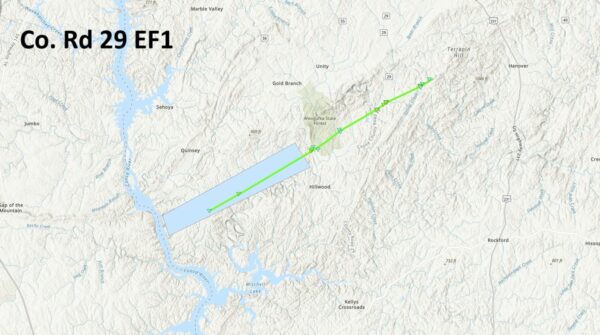

.County Rd 29 Tornado...

Rating:                 EF1
Estimated Peak Wind:    110 mph
Path Length /statute/:  12.02 miles
Path Width /maximum/:   200 yards
Fatalities:             0
Injuries:               0

Start Date:             03/15/2025
Start Time:             09:33 PM CDT
Start Location:         2 NW Dollar / Coosa County / AL
Start Lat/Lon:          32.909 / -86.4495

End Date:               03/15/2025
End Time:               09:50 PM CDT
End Location:           3 ESE Weogufka / Coosa County / AL
End Lat/Lon:            32.9973 / -86.2715

Survey Summary:
National Weather Service Meteorologists surveyed damage in rural
southwestern Coosa County and determined that the damage was
consistent with a tornado.  The tornado began over the Coosa
Wildlife Management area in extreme southwestern Coosa County,
just east of the Coosa River based on satellite imagery.
Unfortunately, that area of the county was not accessible by the
survey crew.  The first area of damage that was accessible
occurred just southwest of County Rd 15, where numerous trees
were snapped and uprooted. The tornado continued northeast,
crossing CC Camp Rd where weak tree damage was noted. The tornado
intensified as it moved northeast and crossed County Rd 29.  The
most extensive damage was found at this location, where numerous
trees were snapped and a double-wide manufactured home was
destroyed. No anchors were found where the manufactured home
originally stood. Farm outbuildings at the same residence were
also destroyed, along with roof damage to surrounding homes.
Winds were estimated at 110mph at this location. Although
difficult to access, EF-0 and EF-1 tree damage was noted farther
to the northeast along County Roads 56 and 18. With areas farther
northeast inaccessible and no damage noted along US Highway 231,
the end point was estimated just beyond County Rd 18.
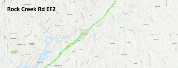
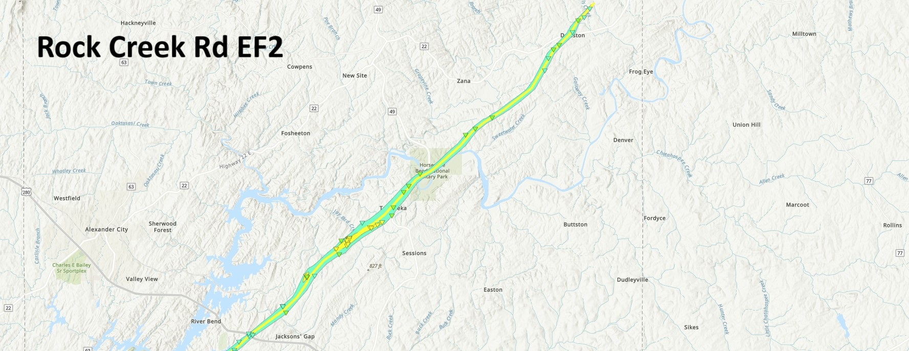
.Horseshoe Bend Tornado ...

Rating:                 EF2
Estimated Peak Wind:    120 mph
Path Length /statute/:  20.44 miles
Path Width /maximum/:   800 yards
Fatalities:             0
Injuries:               0

Start Date:             03/15/2025
Start Time:             10:48 PM CDT
Start Location:         3 NNW Dare Park / Tallapoosa County / AL
Start Lat/Lon:          32.8695 / -85.8778

End Date:               03/15/2025
End Time:               11:12 PM CDT
End Location:           1 NNE Daviston / Tallapoosa County / AL
End Lat/Lon:            33.0711 / -85.6254

Survey Summary:
National Weather Service Meteorologists surveyed damage in
Tallapoosa County and determined that the damage was consistent
with a tornado.  The tornado quickly touched down near Russell
Ferry Estates, crossing County Rd 40 and passing over Midway
Estates Rd. Extensive EF-0 tree damage was observed in this area.
 Some trees fell on homes, where roof damage was sustained.  As
the tornado crossed US Highway 280, minor damage occurred to some
metal buildings of businesses, and numerous trees were snapped or
uprooted.  Farther to the northeast, extensive tree damage was
noted on Abbett Dr, with concentrated tree damage occurring on
Camp Ascca Rd.  A manufactured home sustained roof and
underpinning damage close by, but remained anchored despite
witnesses mentioning that the home almost lifted off the ground.
Just 50 to 75 yards to the west of the home, extensive EF-2 tree
damage was observed. The tornado intensified as it almost
paralleled Rock Springs Road, where a single-wide manufactured
home was destroyed and debris blown 50 to 75 yards away.  Winds
were estimated at 120mph at this location.  The most extensive
tornado damage occurred on McBride Loop just off Rock Springs
Road, where countless numbers of large trees were snapped and
uprooted next to a small lake. In this same location, a single-
wide manufactured home was destroyed, with debris from the home
blown 50 to 75 yards to the northeast.  Thankfully, the resident
of the home was not present and had decided to stay at a local
community storm shelter the night of the event.  Winds were also
estimated at 120mph in this area. Notably, several other homes
located along McBride Loop were left mostly unscathed, and those
that did sustain damage were due to fallen trees. The tornado
continued northeastward at EF-2 intensity as it crossed over Rock
Springs Rd once again, then followed Horseshoe Bend Rd to the
Tallapoosa River.  From there, the tornado moved across Horseshoe
Bend National Military Park. After contacting the Acting Park
Superintendent, valuable information and photos were provided
that indicated extensive EF-2 tree damage on the southwestern and
northeastern side of the park property. Near the battlefield
site, numerous trees were snapped and uprooted, extensively
blocking the Loop Tour Road and causing damage to outbuildings
and an exhibit pavilion. The tree damage on the northeast side of
the park property was very extensive, with countless trees
snapped. Where highest winds occurred, very few trees were left
standing. The tornado continued northeastward crossing County Rd
79 multiple times and moving through the Daviston Community with
EF-0 and EF-1 tree damage noted along the way. Finally, the
tornado moved along Motley Rd and Lil Beaver Rd before finally
lifting.  No damage was found farther northeast along Cotney Rd.
The NWS would like to thank Tallapoosa County EMA and National
Park Service employees for their assistance in conducting this
survey and providing additional information.
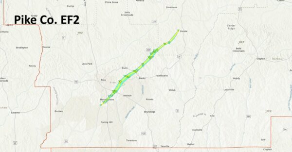
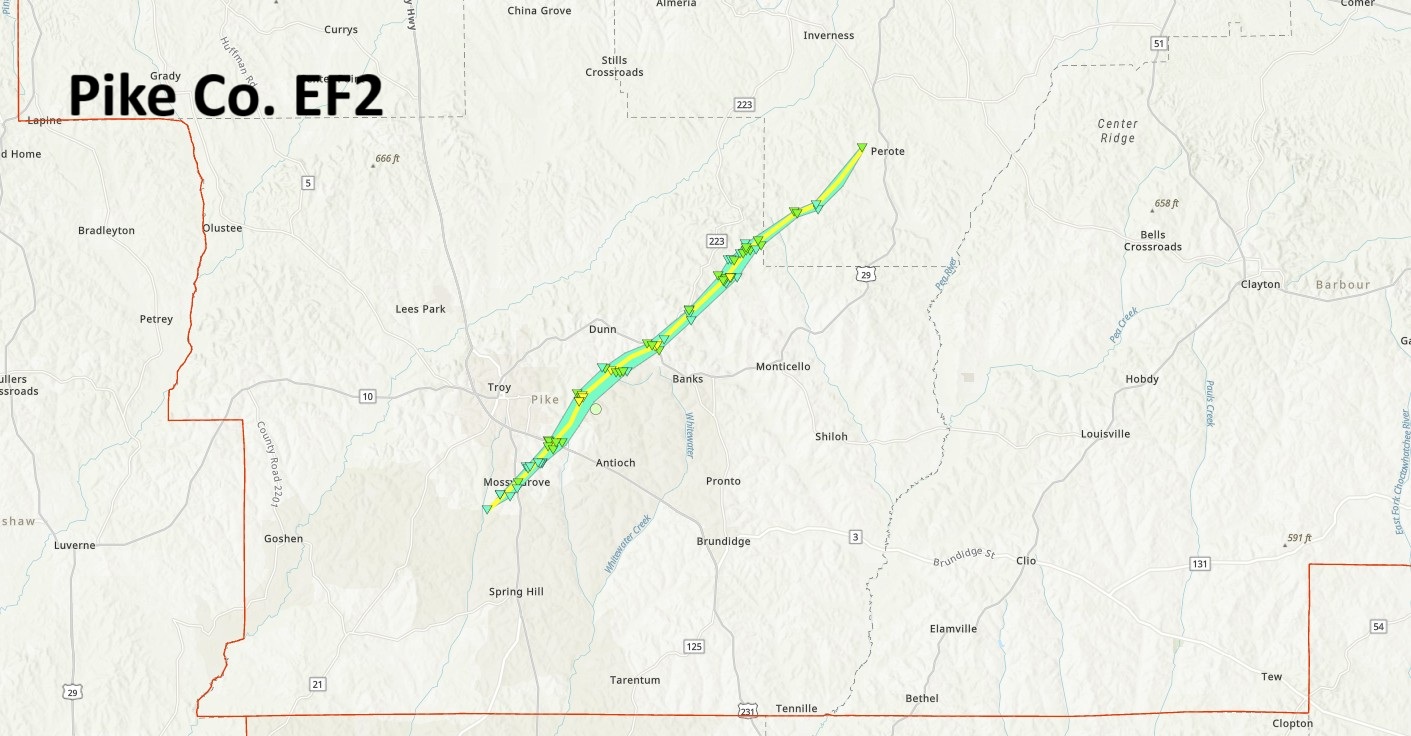
.Pike County Tornado...

Rating:                 EF2
Estimated Peak Wind:    130 mph
Path Length /statute/:  21.29 miles
Path Width /maximum/:   1400 yards
Fatalities:             0
Injuries:               3

Start Date:             03/15/2025
Start Time:             11:02 PM CDT
Start Location:         2 SW Mossy Grove / Pike County / AL
Start Lat/Lon:          31.7383 / -85.9805

End Date:               03/15/2025
End Time:               11:28 PM CDT
End Location:           1 WSW Perote / Bullock County / AL
End Lat/Lon:            31.9491 / -85.723

Survey Summary:
The tornado first touched down on Pike County Road 2228 south of
Troy and west of AL Hwy 87 where a few branches were broken from
several trees in the area.  It travelled northeastward crossing
Pike County Lake Road and then AL Hwy 87.  As it approached Enzor
Rd, it caused significant roof damage to the Troy Parks and
Recreation building, as well as the softball fields at Troy
Sportsplex.  The tornado began to strengthen to EF1 strength as
it approached US Hwy 231, causing significant tree damage with
numerous trees snapped or uprooted, as well as causing
significant damage to a service station canopy.  It continued to
intensify and cause widespread tree damage as it moved up the
Walnut Creek.  The tornado gained its maximum strength at 130 MPH
as it approached Elm Street Road, where one home received major
damage and was rendered uninhabitable.  Several other homes
received indirect damage from tree fall in the area, where barely
a single tree was left standing.  The tornado remained intense as
it crossed Butter and Egg Road, causing widespread tree damage.
The tornado veered slightly eastward and moved into banks, where
widespread tree damage continued, and a metal building received
significant damage as well.  Continuing to the northeast, the
tornado began to gradually weaken in eastern Pike county,
primarily causing more sporadic, less intense tree damage, and
minor damage to structures.  As the tornado crossed into southern
Bullock county, it continued to narrow and weaken until ending at
Bullock CR 8 west of Perote.

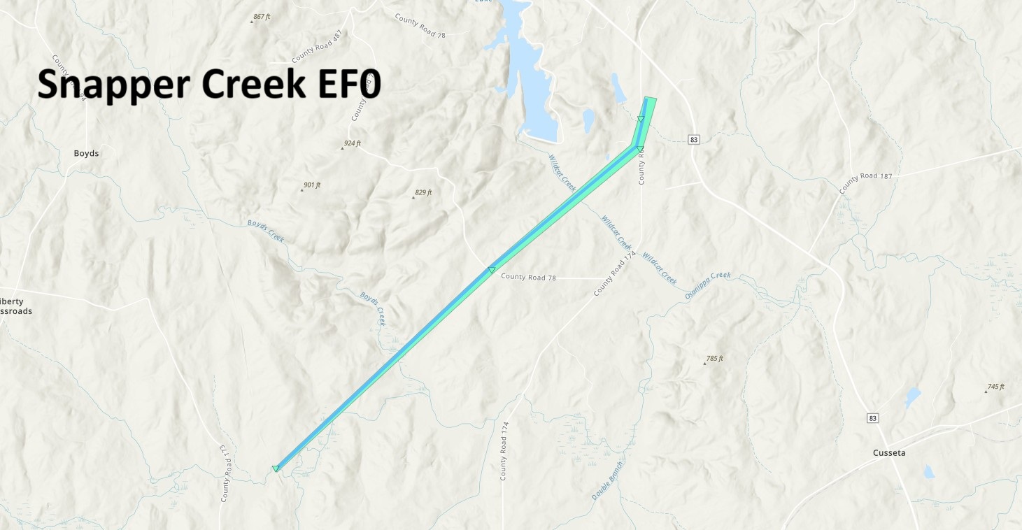
.Snapper Creek Tornado...

Rating:                 EF0
Estimated Peak Wind:    80 mph
Path Length /statute/:  3.80 miles
Path Width /maximum/:   100 yards
Fatalities:             0
Injuries:               0

Start Date:             03/15/2025
Start Time:             11:59 PM CDT
Start Location:         4 SSW Chambers County Lake / Chambers County / AL
Start Lat/Lon:          32.7831 / -85.381

End Date:               03/16/2025
End Time:               12:03 AM CDT
End Location:           1 S Kellys Crossroads / Chambers County / AL
End Lat/Lon:            32.8214 / -85.3355

Survey Summary:
The tornado touched down east of Chambers County Road 173 near
Snapper Creek in rural western Chambers County.  The location is
based on radar analysis of a velocity couplet and developing
debris signature.  The tornado crossed CR 73, where several pine
trees were uprooted.  It continued northeastward crossing CR 174,
where a few pine trees were uprooted.  The tornado weakened and
dissipated before reaching CR 83.
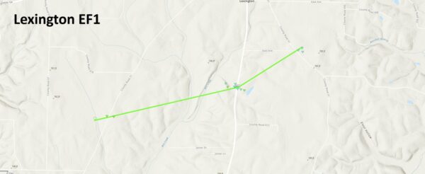
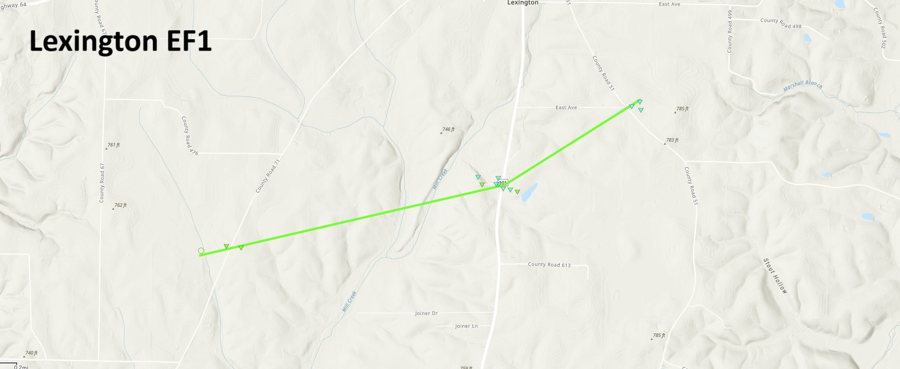
.Lexington Tornado...

Rating:                 EF1
Estimated Peak Wind:    108 mph
Path Length /statute/:  2.29 miles
Path Width /maximum/:   63 yards
Fatalities:             0
Injuries:               0

Start Date:             03/15/2025
Start Time:             02:21 PM CDT
Start Location:         2 SW Lexington / Lauderdale County / AL
Start Lat/Lon:          34.9439 / -87.3985

End Date:               03/15/2025
End Time:               02:25 PM CDT
End Location:           1 SE Lexington / Lauderdale County / AL
End Lat/Lon:            34.9548 / -87.3609

Survey Summary:
The Lexington Tornado touched down on County Line Road 71 in a
field then tracked northeast. It hit an older two-car garage and
shifted it 2-3 inches from its foundation as well as damaged the
back half of the roof, but also snapped and uprooted a few large,
hardwood cedar trees. A small camper was also pushed into an
adjacent truck. The tornado continued northeast and downed and
uprooted numerous additional trees (both hardwood and softwood),
also damaging a fence. The tornado then uprooted and snapped more
trees, with these pointing in various directions, as it progressed
northeast. An outdoor, open-aired metal shed was demolished with
its contents strewn across the yard as well as debris scattered
across the residence and into the adjacent one. Across the street
were more downed trees, snapped limbs, and uprooted trees, with
another outdoor shed that had posts concreted into the ground,
collapsed. Trees caused roof damage to a home at this point and
damaged a vehicle next to it. As the tornado persisted, it
continued to snap trees and tree limbs, while uprooting numerous
other trees until it lifted just across County Road 51.

Lauderdale County EMA utilized their drone to discover that the
tornado started in the aforementioned field before it hit the two-
car garage and snapped the cedar trees. More downed trees were
also discovered via this drone footage around the midpoint of the
track. Special thanks to Lauderdale County EMA for their
assistance with this survey!
Category: Alabama's Weather, ALL POSTS, Social Media
About the Author (Author Profile)
Jack is a junior at Mississippi State University studying meteorology. He has several years of forecasting experience through a local group of forecasters in Maryland where he resides. Jack plans to become a broadcast meteorologist after graduation.Subscribe
If you enjoyed this article, subscribe to receive more just like it.


