Midday Nowcast: Terrific Tuesday; Some Storms Tomorrow Night; Frosty Friday Morning
TERRIFIC TUESDAY: After the chilly start to the day, it is a gorgeous spring day across Alabama. Highs are surging into the low and mid 70s this afternoon under a sky full of sunshine. Tonight will remain clear with lows falling into the upper 40s and lower 50s.
BIRMINGHAM ALMANAC: For March 18th, the average high for Birmingham is 68° and the average low is 45°. The record high is 88° set in 1982, while the record low is 22° set in 1902. We average 0.18” of precipitation on this date and the record value is 1.93” set in 1906.
ACROSS THE USA: Heavy snow over the Northern/Central Rockies on today; light to moderate snow from the Central Plains to the Upper Great Lakes on today; and heavy snow/ blizzard conditions over Central Plains to the Upper Great Lakes on Wednesday. There is a Slight Risk (level 2/5) of severe thunderstorms over parts of the Middle Mississippi/Ohio Valleys and Upper Great Lakes on Wednesday. There is an Extreme Risk of fire weather over the parts of the Southern High Plains on today.
WEDNESDAY NIGHT COLD FRONT: Most of tomorrow will be dry and warm day with highs surging into the upper 70s and lower 80s. Tomorrow evening and night, some showers and storms are possible ahead of a cold front. The SPC maintains a low end “marginal risk” (level 1/5) of severe thunderstorms for areas north and west of Birmingham.
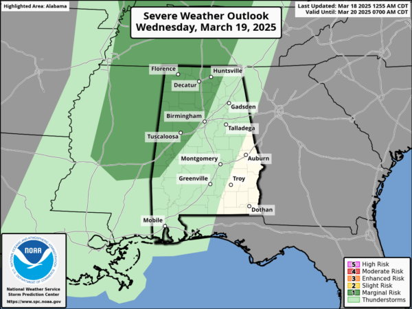
As the front swings through, a few storms along the front could produce small hail and gusty winds, but with little surface based instability and weak dynamic support the overall threat is low. Timing for the storms will be 5PM-Midnight.
COLD FIRST DAYS OF SPRING: The spring equinox occurs at 4:01AM CDT Thursday morning, meaning the official arrival of spring. This is when the sun is directly over the equator. As we start spring, much colder, drier air rolls into the Deep South behind the Wednesday night front. Expect a chilly north breeze Thursday with highs only in the mid 50s with a mostly sunny sky. Areas in the Tennessee Valley will hold in the 40s all days. By Friday morning, we are looking at lows in the 26-35 degree range over the northern half of the state, a widespread frost is likely, while colder spots will see a late season freeze. After the frosty start to the day, Friday will feature sunshine in fully supply with afternoon high generally in the mid 60s.
THE ALABAMA WEEKEND: The weekend still looks dry for Alabama, but showers and storms will then move through Sunday night into early Monday morning.
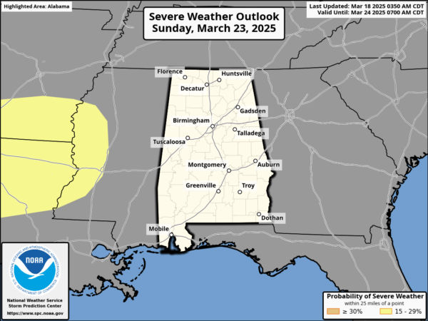
The SPC maintains a defined risk of severe weather west of Alabama for Sunday. The air will be relatively stable across Alabama late Sunday night, which will keep the overall severe threat here fairly low. We will watch model trends closely as we approach the weekend. But the weekend itself will feature more sun than clouds with highs in the low and mid 70s both days.
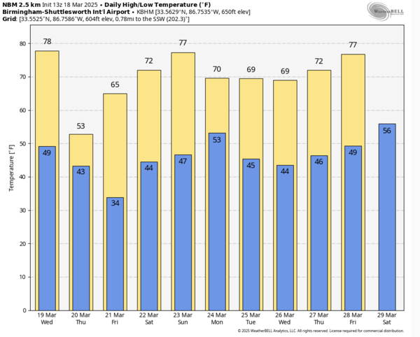
INTO NEXT WEEK: Lingering showers are possible over South Alabama Monday, otherwise the week looks dry and pleasant with highs in the low 70s; lows will be in the 40s and 50s. Both high and low temperatures will be pretty close to seasonal average for late March in Alabama.
WORLD TEMPERATURE EXTREMES: Over the last 24 hours, the highest observation outside the U.S. was 111.7F at Chauk, Myanmar. The lowest observation was -77.1F at Concordia, Antarctica.
CONTIGUOUS TEMPERATURE EXTREMES: Over the last 24 hours, the highest observation was 94F at Rio Grande Village, TX. The lowest observation was 7F at Crosby, ND.
Category: Alabama's Weather, ALL POSTS, Social Media
About the Author (Author Profile)
Macon, Georgia Television Chief Meteorologist, Birmingham native, and long time Contributor on AlabamaWX. Stormchaser. I did not choose Weather, it chose Me. College Football Fanatic. @Ryan_StinnetSubscribe
If you enjoyed this article, subscribe to receive more just like it.


