New Day One Outlook from the Storm Prediction Center
The SPC has issued a high risk for severe thunderstorms across northern and central Alabama, with a dangerous tornado outbreak expected this afternoon and evening. Numerous strong to violent, long-track tornadoes are likely as supercells develop and track northeast across the state. The most intense storms are expected to enter western Alabama by late afternoon, spreading east through the evening and into the overnight hours. A powerful low-level jet will strengthen, increasing wind shear and enhancing the tornado threat. Conditions will be highly favorable for EF3+ tornadoes, along with large hail and damaging winds. This is a life-threatening weather event, and residents should be prepared to take action when warnings are issued.
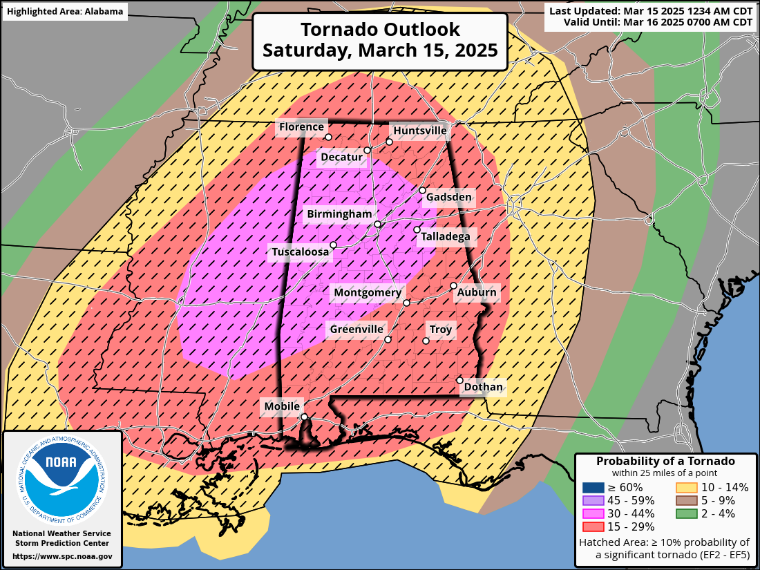
Here is the text of the new Day One Convective Outlook from the Storm Prediction Center.
Day 1 Convective Outlook
NWS Storm Prediction Center Norman OK
1234 AM CDT Sat Mar 15 2025
Valid 151200Z – 161200Z
…THERE IS A HIGH RISK OF SEVERE THUNDERSTORMS ALONG A CORRIDOR
FROM CENTRAL MISSISSIPPI INTO NORTHERN/CENTRAL ALABAMA…
…SUMMARY…
A tornado outbreak is expected across the central Gulf Coast States
and Deep South into the Tennessee Valley. Numerous significant
tornadoes, some of which should be long-track and potentially
violent, are expected this afternoon and evening. The most dangerous
tornado threat should begin across eastern Louisiana and Mississippi
during the late morning to afternoon, spread across Alabama late day
into the evening, and reach western parts of the Florida Panhandle
and Georgia Saturday night.
…Central Gulf States/Tennessee Valley Region…
Strong cyclone that is lifting northeast across the upper MS Valley
will eject into northwest Ontario later today as a very strong
mid-level speed max digs southeast across northern Mexico into
south-central TX. Later tonight, this jet will translate into the
central Gulf States with winds in excess of 110kt. In response to
this feature, a surface low should evolve along the trailing
boundary along the TX/LA border early in the period, then track
northeast into western KY by 16/00z. Additionally, an intense LLJ
will evolve by mid day across northern MS and strengthen during the
afternoon as it gradually shifts downstream into AL/middle TN/KY by
early evening. Net result should be for a bit higher moisture
content to advance farther north than previous thought.
Early this morning, an arcing band of scattered supercells extended
across southern IL into eastern AR. More isolated activity has
persisted much of the late evening across portions of MS. Latest
thinking is convective overturning should remain minimal across the
lower MS Valley and this will allow significant destabilization to
materialize ahead of the surface low early in the period. Latest
surface data depicts lower 70s dew points across southern
LA/southwest MS, with mid 60s approaching the south side of the
Memphis metro. Confidence is increasing that a corridor of strong
buoyancy and intense shear will be in place prior to the
aforementioned speed max/short-wave trough. Forecast soundings
exhibit steep mid-level lapse rates with ESRH in excess of 500 m2/s2
across a broad swath of the central Gulf States, especially the
categorical High Risk delineation.
While scattered strong/severe thunderstorms will likely be ongoing
at the start of the period across the western TN Valley, convection
should increase in intensity by late morning across LA as the
leading edge of the approaching short wave begins to influence this
region. Continued boundary-layer heating will lead to subsequent
development and supercells should mature and race northeast as the
flow strengthens. This flow regime favors long-lived tornadoes, and
the parameter space suggests potentially violent, long-track
tornadoes. This activity will grow upscale in both coverage and
intensity through late afternoon as the overall severe complex
shifts downstream. Large hail and damaging winds may also accompany
these storms, but the primary concern today will be the likelihood
for a tornado outbreak, especially across Mississippi into Alabama.
..Darrow/Moore.. 03/15/2025
CLICK TO GET WUUS01 PTSDY1 PRODUCT
NOTE: THE NEXT DAY 1 OUTLOOK IS SCHEDULED BY 1300Z
CURRENT UTC TIME: 0607Z (1:07AM), RELOAD THIS PAGE TO UPDATE THE TIME
Category: Alabama's Weather, ALL POSTS, Severe Weather
About the Author (Author Profile)
Bill Murray is the President of The Weather Factory. He is the site's official weather historian and a weekend forecaster. He also anchors the site's severe weather coverage. Bill Murray is the proud holder of National Weather Association Digital Seal #0001 @wxhistorianSubscribe
If you enjoyed this article, subscribe to receive more just like it.


