For Your Overnight and Early Morning
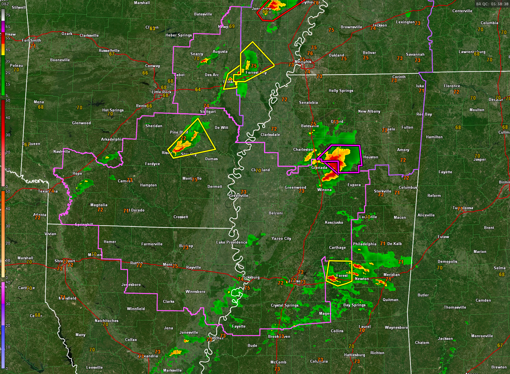
Watching a dangerous supercell over North central Mississippi that has produced several tornadoes. The NWS Memphis has issued new tornado warnings to the northeast of this supercell, but they are radar indicated now instead of confirmed, which is good news. The shear over North Mississippi is uniformly high, but the instability lessens slightly as you travel to the northeast.
A tractor trailer was overturned on I-55 near Duck Hill or south of Grenada. This storm is moving toward Big Creek and Vardaman.
The instability lessens further into Northwest Alabama and the storms should become non-tornadic as they move into Northwest Alabama over parts of Lauderdale, Colbert, Franklin, and Marion Counties around 3-4 a.m.
We are tracking more storms over East Central Mississippi early this morning, east of Jackson. These storms are not being depicted well by the convection allowing models so we will have to keep an eye on them. A have our first severe thunderstorm warning now for Rankin and Smith Counties. The atmosphere in this area in eastern Mississippi and western Alabama is conducive for tornadoes now and will be for the next few hours as well. CAPE values are running over 2,000 joules/kg with 0-1 km helicity values around 275 m2/s2 which is supportive of tornadoes, so we will have to watch the storms in Scott County as it perhaps intensifies.
Bottom line, storms will be pushing into western Alabama between 2:30 and 4 a.m. this morning. Storms will be potentially tornadic.
A PDS Tornado Watch is in effect for northeastern Mississippi until 3 a.m. and a standard Tornado Watch for central and western Mississippi until 5 a.m. Watches will most likely be extended eastward in the next couple of hours.
The activity will diminish after 8 a.m. over the Tennessee Valley and there will be a bit of a lull before more storms start affecting western Alabama as early as 11 a.m. or noon. It will be a rough afternoon and overnight with all modes of severe weather possible.
.
Category: Alabama's Weather, ALL POSTS, Severe Weather, Social Media
About the Author (Author Profile)
Bill Murray is the President of The Weather Factory. He is the site's official weather historian and a weekend forecaster. He also anchors the site's severe weather coverage. Bill Murray is the proud holder of National Weather Association Digital Seal #0001 @wxhistorianSubscribe
If you enjoyed this article, subscribe to receive more just like it.


