Dangerous severe weather outbreak unfolding…First round tonight…Main event Saturday
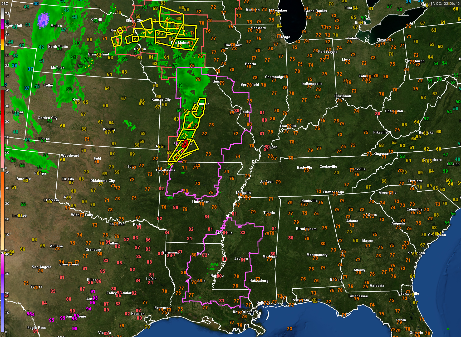
A Tornado Watch has been issued to our west for eastern Louisiana, far southeastern Arkansas, and western Mississippi until 10:00 p.m. CDT. This watch covers areas where supercell thunderstorms are expected to develop in the next couple of hours, posing a risk for tornadoes, some strong, large hail up to two inches in diameter, and damaging winds up to 70 mph. Recent satellite and radar analysis confirms that storms are beginning to develop along a convergence zone in Louisiana, with increasing instability and a strengthening low-level jet contributing to a highly favorable tornado environment as the evening progresses.
To the northwest, another tornado watch covers much of Missouri, western Illinois, and northern Arkansas. There are numerous severe thunderstorm warnings and one tornado warning right now across the Show Me state of Missouri. Further north, there are numerous warnings in a severe thunderstorm watch in eastern Nebraska and Iowa.
Round one – overnight severe weather threat. Storms will begin moving into West Alabama after 11:00 p.m. and continue through approximately 8:00 a.m. Saturday. SPC has outlined an enhanced risk, level three of five, for much of West Alabama, with a slight risk, level two of five, extending as far east as Scottsboro, Prattville, and Jackson. A tiny corner of Northwest Alabama is in the Moderate Risk for overnight (Level 4 out of 5). This round of storms will likely be scattered in nature, but where they do form, they will be capable of producing large hail, damaging winds, and isolated tornadoes. The highest tornado threat overnight will be west of I-65, while areas farther east may remain more stable until later in the day Saturday.
Round two – high-end tornado outbreak Saturday. This will be the more widespread, high-impact round of storms, developing ahead of an approaching cold front from noon Saturday through 3:00 a.m. Sunday. SPC has issued a high risk, level five of five, for parts of central Mississippi and Alabama, including Tuscaloosa and Birmingham, a rare designation reserved for the most dangerous severe weather situations. The rest of Alabama remains in a moderate risk, level four of five. Conditions will be supportive of long-track, violent tornadoes, destructive wind gusts exceeding 80 mph, and hail larger than golf balls. A strongly sheared and unstable warm sector will develop across the state, leading to intense, rotating supercells capable of producing EF3+ tornadoes.
Flooding and wind threat. With repeated rounds of heavy rain, a Flash Flood Watch has been issued for the northern third of Alabama where rainfall totals could reach three to five inches, with localized amounts higher, leading to flash flooding and river flooding concerns. A Wind Advisory is also in effect for most of the state, with non-thunderstorm gradient winds gusting to 35 mph or higher.
Critical safety messages. Have multiple ways to receive warnings, especially at night. Do not rely on outdoor sirens. The baseline is a NOAA Weather Radio and emergency alerts enabled on your phone. Wear helmets in your safe place. Most tornado-related fatalities are due to head injuries. Wear hard shoes in case you need to walk through debris. If you live in a manufactured home, you must seek shelter. Know where your nearest shelter or sturdy structure is and be prepared to get there quickly. Do not try to escape a tornado in a vehicle. If a tornado warning is issued while driving, stop and take shelter inside a gas station, fast food restaurant, or sturdy building. Stay informed and help others. If you know someone who might not be paying attention, reach out and let them know about the threat. Sharing information could save lives.
What’s next. Expect a long-duration event with multiple waves of severe weather. Conditions will improve Sunday morning, but lingering showers and gusty winds are possible. Next week will be quieter, with another system arriving late Wednesday, though current guidance does not indicate another high-end severe weather event. This is a dangerous situation, but we will remain calm and take it one storm at a time to get through it. Stay weather aware, have a plan, and be prepared to act quickly if a warning is issued for your area. More updates will follow as the situation unfolds.
Category: Alabama's Weather, ALL POSTS, Severe Weather, Social Media
About the Author (Author Profile)
Bill Murray is the President of The Weather Factory. He is the site's official weather historian and a weekend forecaster. He also anchors the site's severe weather coverage. Bill Murray is the proud holder of National Weather Association Digital Seal #0001 @wxhistorianSubscribe
If you enjoyed this article, subscribe to receive more just like it.


