Midday Nowcast: Violent, Severe Weather Outbreak Ahead for Alabama
VIOLENT, SEVERE WEATHER OUTBREAK AHEAD: Alabamians will need to pay very close attention to the weather tonight through tomorrow night as a dynamic storm system will bring violent thunderstorms to the state. Prepare for a major severe/tornado outbreak across the south as we are going to have two rounds of severe storms impact Alabama with the first occurring tonight into early tomorrow. The second, and more impactful event, will occur tomorrow afternoon and night.
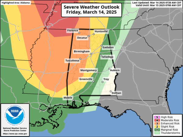
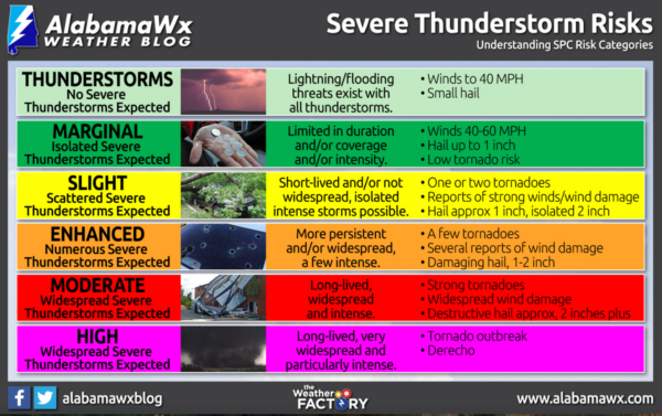
ROUND ONE: The SPC has much of the state in the threat of severe storms today into tomorrow, with an “enhanced risk” (level 3 of 5) for western portions of the state. Hail, damaging winds, and a few tornadoes are possible. The highest risk of severe storms with “round one” will be over the western half of the state, mainly along and west of I-65. The severe threat is much lower over the eastern counties, where the air will be more stable.
TIMING: This first round of severe thunderstorms will come from around 11:00PM tonight through 8AM tomorrow. With this round occurring during the overnight hours, make sure you have ways to receive severe weather alerts.
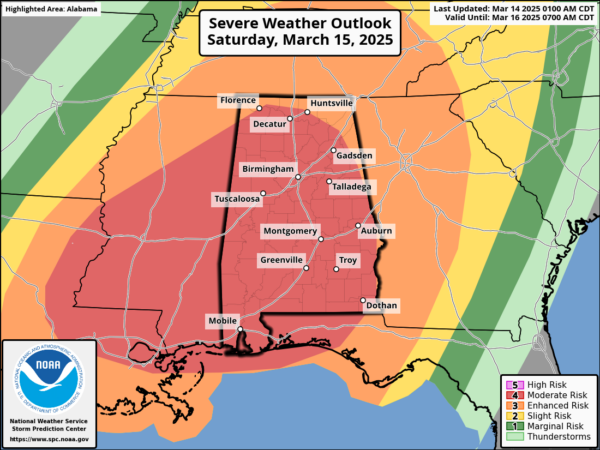
ROUND TWO: This will be the higher impact event and will occur from 12PM noon Saturday through 3AM Sunday morning.
The (SPC) has expanded the “moderate risk” (level 4 of 5) of severe storms to cover nearly all of Alabama, and again, I would not be surprised to see portions of the risk get increased to the highest risk level by tomorrow, a very rare “High Risk” (level 5 of 5).
We don’t use strong wording often, but in this case it is needed. The threat is real, and the event poses a dangerous and life-threatening situation for all of Alabama and most of the southern U.S.
THREATS: Storms will be capable of producing very large hail (larger than golf balls), damaging winds (greater than 70 mph), and tornadoes. Strong, violent, long-track tornadoes are possible, this would include tornadoes rated higher than EF-2, which produce tremendous amounts of damage and often cause loss of life.
Make sure you are paying attention to future updates, but the overall forecast is not going to change much and a very dangerous severe weather event is all but certain. We don’t share any of this to scare people. But strong wording is necessary on occasion, and this is one of those times.
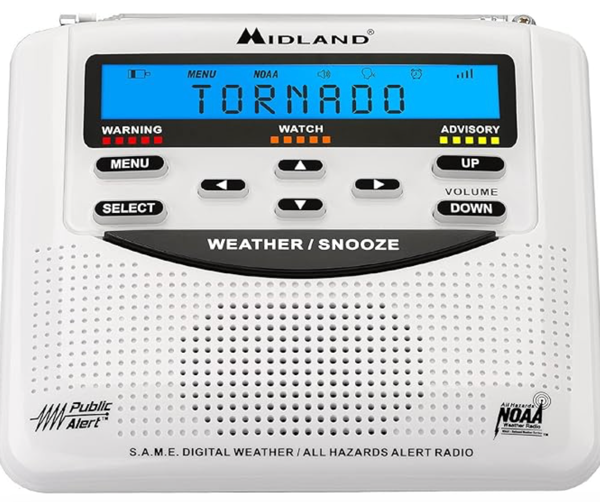
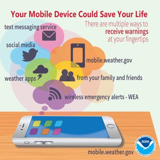
CALL TO ACTION: With any severe weather event, be ready to act immediately…Have multiple, reliable ways to receive severe weather alerts, NEVER, ever, ever rely on a outdoor siren. Every Alabama home and business needs a NOAA Weather Radio (the most popular model is the Midland WR-120, which is sold in most local big box retailers).
The other way is your phone…be sure emergency alerts are enabled (look under settings, and notifications), and install the free ABC 33/40 Weather app.
Know the safe place in your house, and in that safe place have helmets for everyone. Bicycle helmets and batting helmets work well. We also recommend portable air horns and hard soled shoes for everyone. If you live in an apartment complex, you can’t be above the first level. Shelter with a friend on the ground level, or ask management if they can open the clubhouse during a tornado warning.
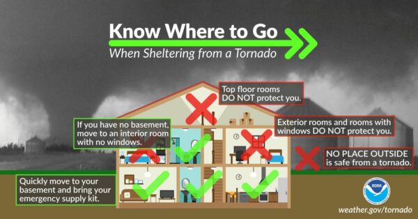
If you live in a mobile home, you cannot stay there during a tornado warning, they offer little to know protection from severe storms. Know the location of the nearest shelter, or business that is open 24/7. Know how to get there quickly.
A car is a death trap during a tornado. If you are driving and get a tornado warning notification, pull off as quickly as possible and go into a gas station, fast food restaurant, or any other business that can serve as a shelter.
Subscribe to the James Spann and ABC 33/40 YouTube channels so you can watch our live coverage. We are thankful for the out of state YouTubers who do long form severe weather coverage, but to be truly successful in reaching people and communicating warnings in high end severe weather events like this, you have to understand the people, culture, geography, and microclimate of the region impacted.
BE A HERO: You can help us. Tell your friends, neighbors, and relatives about the threat, and what they need to do to get ready. And, if they fall in a tornado warning polygon, call them or text them to let them know about the threat. You are our most valuable resource in spreading the word!
Again, this is the core of our severe weather season in Alabama, so events like this are not uncommon. Many of you have anxiety about severe weather, especially those that have gone through tornadoes or other kinds of violent weather. Have comfort knowing that even on the biggest severe weather days, odds of any one home being hit by a tornado are very low. But, you have to pay attention and be prepared. We will get through the event together.
AFTER THE STORMS: Dry air returns Sunday; highs will be in the 60s and 70s. The first half of the following week looks dry and mild; rain and storms are likely to late Wednesday, for now it does’t look like a severe weather threat.
BIRMINGHAM ALMANAC: For March 14th, the average high for Birmingham is 67° and the average low is 45°. The record high is 84° set in 1967, while the record low is 2° set in 1993. We average 0.18” of precipitation on this date and the record value is 3.15” set in 1929.
WORLD TEMPERATURE EXTREMES: Over the last 24 hours, the highest observation outside the U.S. was 112.3F at Forrest, Australia. The lowest observation was -84.1F at Vostok, Antarctica.
CONTIGUOUS TEMPERATURE EXTREMES: Over the last 24 hours, the highest observation was 100F at Faith Ranch, TX. The lowest observation was -6F at MacKay, ID.
Category: Alabama's Weather, ALL POSTS, Severe Weather, Social Media
About the Author (Author Profile)
Macon, Georgia Television Chief Meteorologist, Birmingham native, and long time Contributor on AlabamaWX. Stormchaser. I did not choose Weather, it chose Me. College Football Fanatic. @Ryan_StinnetSubscribe
If you enjoyed this article, subscribe to receive more just like it.


